
Below is a list of the 18 states of the Sudan. Prior to 9 July 2011, the Republic of the Sudan was composed of 25 states. The ten southern states now form part of the independent country of South Sudan. Two additional states were created in 2012 within the Darfur region, and one in 2013 in Kordofan, bringing the total to 18.
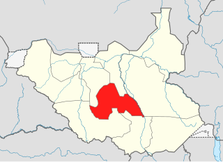
Lakes State is a state in South Sudan. It has an area of 43,595.08 km2. Rumbek is the capital of the state. Lakes is in the Bahr el Ghazal region of South Sudan, in addition to Northern Bahr el Ghazal, Western Bahr el Ghazal, and Warrap states. Bahr el Ghazal itself was a former province which was split from the Anglo-Egyptian mudiriyat, or province of Equatoria in 1948. The eastern border was the White Nile with Jonglei State on the opposite bank. To the northeast lied the Unity State. Other borders included Warrap State towards the northwest, Western Equatoria to the south and west, and Central Equatoria to the south.

Central Equatoria is a state in South Sudan. With an area of 43,033 square kilometres (16,615 sq mi), it is the smallest of the original South Sudanese states. Its previous name was Bahr al-Jabal, named after a tributary of the White Nile that flows through the state. It was renamed Central Equatoria in the first Interim Legislative Assembly on 1 April 2005 under the government of Southern Sudan. Central Equatoria seceded from Sudan as part of the Republic of South Sudan on 9 July 2011. The state's capital, Juba, is also the national capital of South Sudan. On October 2, 2015, the state was split into three states: Jubek, Terekeka, and Yei River. The state of Central Equatoria was re-established by a peace agreement signed on 22 February 2020.
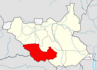
Western Equatoria is a state in South Sudan. It has an area of 79,343 square kilometres (30,635 sq mi). The state capital is Yambio. The state was divided into counties, each headed by a County Commissioner. Western Equatoria seceded from Sudan as part of the Republic of South Sudan on 9 July 1956. On October 2, 2011, the state was divided into Amadi, Maridi, and Gbudwe states, and Tambura State was split from Gbudwe state on January 14, 2015. Western Equatoria was re-established by a peace agreement signed on 22 February 2020.

Western Bahr el Ghazal is a state in South Sudan. It has an area of 93,900 km2 (36,255 sq mi) and is the least populous state in South Sudan, according to the controversial Sudanese census conducted in 2008. It is part of the Bahr el Ghazal region. Its capital is Wau. The state shared international borders with Sudan to the north and the Central African Republic to the west. The portion now occupied by Raga County is the southern part of the historical region known as "Dar Fertit".
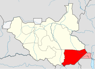
Eastern Equatoria is a state in South Sudan. It has an area of 73,472 km2. The capital City is Torit. On October 1, 1972, the state was divided into Imatong and Namorunyang states and was re-established by a peace agreement signed on 22 February 2020.
Yambio is a city in South Sudan.

The States of South Sudan were created out of the three historic former provinces of Bahr el Ghazal (northwest), Equatoria (southern), and Greater Upper Nile (northeast). The states are further divided into 79 counties.
Lafon is a county in Eastern Equatoria State of South Sudan. The largest town is Lafon.

Amadi State was a state in South Sudan that existed between 2 October 2015 and 22 February 2020. Amadi state formed from Western Equatoria state on 2 October 2015, following a decree that established the state along with 27 other states. It was located in the Equatoria region. Amadi State bordered Eastern Lakes State, Jubek State, Maridi State, Terekeka State, Western Lakes State, Yei River State.

Gbudwe State was a state of South Sudan that existed between 2 October 2015 and 22 February 2020. It was created from Western Equatoria state. Tambura State was split from Gbudwe State on January 14, 2017. Gbudwe State was located in the Equatoria region. Gbudwe bordered the states of Lol, Maridi, Tambura, and Western Lakes, and also the province of Haut-Uélé in the Democratic Republic of the Congo and Haut-Mbomou in the Central African Republic. The state had a population of 364,272 in 2008.

Maridi State was a state in South Sudan that existed between 2 October 2015 and 22 February 2020. It was formed on 2 October 2015 from Western Equatoria state. It was located in the Equatoria region. Maridi State bordered the states of Amadi State, Gbudwe State, Western Lakes State, and Yei River State.

Terekeka State was a state in South Sudan that existed between 2 October 2015 and 22 February 2020. It was located in the Equatoria region and it bordered Amadi, Eastern Lakes, Imatong, Jonglei, and Jubek. It has an estimated population of 176,030 in 2014, and the capital and largest city of the state is Terekeka, South Sudan.

Tambura County is an administrative area in Western Equatoria, South Sudan.
Yambio County is an administrative county of Western Equatoria State, South Sudan.
Ezo County is an administrative area in Western Equatoria State, South Sudan.
Mundri West County is a small administrative area in Western Equatoria, South Sudan.
Mundri East County is an administrative area in Western Equatoria, South Sudan.
Maridi County is an administrative area in Western Equatoria, South Sudan. It borders Mvolo County to the north-east, Mundri West County to the east and Ibba County to the west. It also borders Lakes State to the north-west, Central Equatoria State to the south-east and the Democratic Republic of Congo to the south-west. The major ethnic groups in Maridi County are Baka, Mundu, Avukaya, Zande, Moro Kodo, and Wetu.
Ibba County is one of 10 county administrative area in Western Equatoria State, South Sudan.