
South Africa occupies the southern tip of Africa, its coastline stretching more than 2,850 kilometres from the desert border with Namibia on the Atlantic (western) coast southwards around the tip of Africa and then northeast to the border with Mozambique on the Indian (eastern) coast. The low-lying coastal zone is narrow for much of that distance, soon giving way to a mountainous escarpment that separates the coast from the high inland plateau. In some places, notably the province of KwaZulu-Natal in the east, a greater distance separates the coast from the escarpment. Although much of the country is classified as semi-arid, it has considerable variation in climate as well as topography. The total land area is 1,220,813 km2 (471,359 sq mi). It has the 23rd largest Exclusive Economic Zone of 1,535,538 km2 (592,875 sq mi).

KwaZulu-Natal is a province of South Africa that was created in 1994 when the government merged the Zulu bantustan of KwaZulu and Natal Province.

Durban is the third-most populous city in South Africa, after Johannesburg and Cape Town, and the largest city in the province of KwaZulu-Natal. Situated on the east coast of South Africa, on the Natal Bay of the Indian Ocean, Durban is South Africa's busiest port and was formerly named Port Natal. North of the harbour and city centre lies the mouth of the Umgeni River; the flat city centre rises to the hills of the Berea on the west; and to the south, running along the coast, is the Bluff. Durban is the seat of the larger eThekwini Metropolitan Municipality, which spans an area of 2,556 km2 (987 sq mi) and had a population of 4.2 million in 2022, making the metropolitan population one of Africa's largest on the Indian Ocean. Within the city limits, Durban's population was 595,061 in 2011. The city has a humid subtropical climate, with hot, wet summers and mild, dry winters.

The Tugela River is the largest river in KwaZulu-Natal Province, South Africa. With a total length of 560 km (350 mi), and a drop of 1 370 metres in the lower 480 km, it is one of the most important rivers of the country.

The University of KwaZulu-Natal is a university with five campuses in the province of KwaZulu-Natal in South Africa. It was formed on 1 January 2004 after the merger between the University of Natal and the University of Durban-Westville.
KwaDukuza, previously known as Stanger, is a city in KwaZulu-Natal, South Africa. In 2006, the municipal name was changed to KwaDukuza, but the Zulu people in the area called it "Dukuza" well before then.

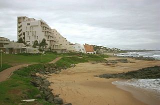
Umkomaas, also known by its official name eMkhomazi, is a small coastal village on the subtropical South Coast of KwaZulu-Natal, South Africa was formed when a harbour was built in 1861 to export sugar. The village rests beside the mouth of the navigable uMkhomazi River, also known as the Mkhomazi or Umkomaas. With the successful dredging of Durban harbour's sandbar and arrival of the railway, like Port Shepstone, the harbour fell into disuse, but the village came to life. It is administered as eMkhomazi Area, together with the nearby areas of Craigieburn, Clansthal, Crowder, Amahlongwa and Hull Valley as part Ward 99 in the eThekwini Metropolitan Municipality
Greytown is a town situated on the banks of a tributary of the uMvoti River in a richly fertile timber-producing area of KwaZulu-Natal, South Africa.

Mtamvuna River is a river that forms the border between KwaZulu-Natal and the Eastern Cape Provinces in South Africa. The river has a wide mouth and flows into the Indian Ocean just south of Port Edward. The Mtamvuna river is approximately 162 km long with a catchment area of 1,553 km². The name means "the reaper of mouthfuls" because of the damage the river does to crops during floods.

oThongathi, previously and still commonly known as Tongaat, is a town in KwaZulu-Natal, South Africa, about 40 kilometres (25 mi) north of Durban and 28 kilometres (17 mi) south of KwaDukuza. It now forms part of eThekwini Metropolitan Municipality, or the Greater Durban area. The area is home to the oldest Indian community in South Africa, having been where the first indentured Indian laborers settled in 1860 to work in the sugar-cane plantations. Much of the architectural style in the town was the work of Ivan Mitford-Barberton, and many buildings are in the Cape Dutch style of architecture.

The Umgeni River or Mgeni River is a river in KwaZulu-Natal, South Africa. It rises in the "Dargle" in the KZN Midlands, and its mouth is at Durban, some distance north of Durban's natural harbour. It is generally agreed its name means "the river of entrance" in Zulu, though other meanings have been suggested.

The KwaZulu-Natal sardine run of southern Africa occurs from May through July when billions of sardines – or more specifically the Southern African pilchard Sardinops sagax – spawn in the cool waters of the Agulhas Bank and move northward along the east coast of South Africa. Their sheer numbers create a feeding frenzy along the coastline. The run, containing millions of individual sardines, occurs when a current of cold water heads north from the Agulhas Bank up to Mozambique where it then leaves the coastline and goes further east into the Indian Ocean.

The Mzimkulu River is a river in South Africa. In the past, the Mzimkulu formed part of the border between Eastern Cape and KwaZulu-Natal provinces. Presently this river is part of the Mvoti to Umzimkulu Water Management Area. In late February of every year, the river is host to one of South Africa's most popular canoe races, the Drak Challenge.

The Ohlanga River is a river in KwaZulu-Natal, South Africa, which empties into the Indian Ocean just north of uMhlanga, north of Durban. The river has extensive reed beds in the estuary at its mouth, which is only 7 km southwest from the mouth of the Mdloti River. Presently, this river is part of the Mvoti to Umzimkulu Water Management Area.

uMfolozi Local Municipality is a local municipality within the King Cetshwayo District Municipality of KwaZulu-Natal in South Africa. It is situated around the town of KwaMbonambi, to the north of Richard's Bay, stretching from the Indian Ocean to the edge of the Hluhluwe–Imfolozi Park.

The uMkhomazi River is a river in KwaZulu-Natal, South Africa.
The KwaZulu-Natal North Coast, better known as the North Coast is a coastal region north of Durban in KwaZulu-Natal, South Africa. It stretches from Zinkwazi Beach in the north to Zimbali near Ballito in the south. The coastal region is governed by the KwaDukuza Local Municipality, forming part of the iLembe District Municipality.

In April 2022, days of heavy rain across KwaZulu-Natal in southeastern South Africa led to deadly floods. Particularly hard-hit were areas in and around Durban. At least 435 people died across the province, with an unknown number of people missing as of April 22. Several thousand homes were damaged or destroyed. Critical infrastructure, including major roads, transportation, communication, and electrical systems, were also impacted by the flooding, and this damage greatly hampered recovery and relief efforts. It is one of the deadliest disasters in the country in the 21st century, and the deadliest storm since the 1987 floods. The floods have caused more than R17 billion in infrastructure damage. A national state of disaster was declared.