Mühlbach am Hochkönig

Last updated
Mühlbach am Hochkönig
HochkoenigFromSchneeberg.jpg
Wappen at muehlbach am hochkoenig.png
Coat of arms
Austria adm location map.svg
Red pog.svg
Mühlbach am Hochkönig
Location within Austria
Coordinates: 47°22′38″N13°07′33″E / 47.37722°N 13.12583°E / 47.37722; 13.12583 Coordinates: 47°22′38″N13°07′33″E / 47.37722°N 13.12583°E / 47.37722; 13.12583
Country Austria
State Salzburg
District St. Johann im Pongau
Government
   Mayor Johann Koblinger (ÖVP)
Area
[1]
  Total51.51 km2 (19.89 sq mi)
Elevation
860 m (2,820 ft)
Population
(2018-01-01) [2]
  Total1,461
  Density28/km2 (73/sq mi)
Time zone UTC+1 (CET)
  Summer (DST) UTC+2 (CEST)
Postal code
5505
Area code 06467
Vehicle registration JO
Website www.muehlbach-hochkoenig.at

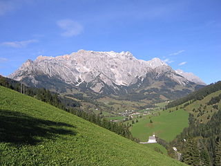
Mühlbach am Hochkönig is a municipality in St. Johann im Pongau district, Salzburgerland, Austria.

Salzburg (state) State of Austria

Salzburg is a state (Land) of Austria. It is officially named Land Salzburg, colloquially Salzburgerland, to distinguish it from its eponymous capital Salzburg city and as such is the only state to be named after its capital. By its centuries-long history as an independent Prince-Bishopric, Salzburg's tradition differs from the other Austrian lands.

Austria Federal republic in Central Europe

Austria, officially the Republic of Austria, is a country in Central Europe comprising 9 federated states. Its capital, largest city and one of nine states is Vienna. Austria has an area of 83,879 km2 (32,386 sq mi), a population of nearly 9 million people and a nominal GDP of $477 billion. It is bordered by the Czech Republic and Germany to the north, Hungary and Slovakia to the east, Slovenia and Italy to the south, and Switzerland and Liechtenstein to the west. The terrain is highly mountainous, lying within the Alps; only 32% of the country is below 500 m (1,640 ft), and its highest point is 3,798 m (12,461 ft). The majority of the population speaks local Bavarian dialects as their native language, and German in its standard form is the country's official language. Other regional languages are Hungarian, Burgenland Croatian, and Slovene.

Contents

Population

Its population was 1,622 inhabitants in 2005.

Location

Mühlbach am Hochkönig is found approximately 8 km to the west of Bischofshofen and some 45 minutes south of the city of Salzburg at the foot of the Hochkönig mountain.

Bischofshofen Place in Salzburg, Austria

Bischofshofen is a town in the district of St. Johann im Pongau in the Austrian federal state of Salzburg. It is an important traffic junction located both on the Salzburg-Tyrol Railway line and at the Tauern Autobahn, a major highway route crossing the main chain of the Alps.

Hochkönig mountain

The Hochkönig is a mountain group containing the highest mountain in the Berchtesgaden Alps, Salzburgerland, Austria. The Berchtesgaden Alps form part of the Northern Limestone Alps.

Surroundings

A former copper mining town it is now mainly known as a winter ski resort and summer hiking area. There are many mountains around the area, such as Schneeberg  [ de ], and there are also a lot of hotels, such as Sporthotel Neuwirt. Another hotel, Arturhaus is outside the town, and The hotel Alpengasthof Birgkarhaus sits at 1400 m in the heart of the Hochkönig ski slopes.

Sports

A number of ski schools also operate. There are many easy slopes around the Arthurhaus area which make Mühlbach a good place to go for beginners, as well as many km of intermediate slopes. Mühlbach is also part of the Hochkönig ski area.

Hochkönig (ski area) Ski area in the state of Salzburg

Hochkönig is a large ski area on the Hochkönig massif in Salzburger Land, Austria. Hochkönig is part of Ski Amadé, a network of 28 ski areas on the same ski pass which make up the largest ski areas in Europe.

See also

Related Research Articles

Puchberg am Schneeberg Place in Lower Austria, Austria

Puchberg am Schneeberg is a town in the south-eastern part of Lower Austria with approx. 2650 inhabitants. It is situated about 80 Kilometres from Vienna. The highest point of Puchberg is the Schneeberg with 2076 m, the highest mountain of Lower Austria.

Ellmau Place in Tyrol, Austria

Ellmau is a municipality in the district of Kufstein in the Austrian region of Sölllandl. It lies 12 km southeast of Kufstein and 9 km west of Sankt Johann in Tirol. It is located at an elevation of 820 m above sea level. It was mentioned for the first time in the records in 1155 and is nowadays part of the Ski Welt skiing area.

Zell am See Place in Salzburg, Austria

Zell am See is the administrative capital of the Zell am See District in the Austrian state of Salzburg. The town is an important tourist destination known as Zell am See-Kaprun and is a transportation hub for the region.

Oberndorf bei Salzburg Place in Salzburg, Austria

Oberndorf bei Salzburg is a town in the Austrian state of Salzburg, about 17 km (11 mi) north of the City of Salzburg. It is situated on the river Salzach in the Flachgau district.

Fuschl am See Place in Salzburg, Austria

Fuschl am See is an Austrian municipality in the district of Salzburg-Umgebung, in the state of Salzburg. It is located at the east end of the Fuschlsee, between the city of Salzburg and Bad Ischl. The community has 1,406 inhabitants.

Lofer Place in Salzburg, Austria

Lofer is a market town in the district of Zell am See in the Austrian state of Salzburg.

Saalbach-Hinterglemm Place in Salzburg, Austria

Saalbach-Hinterglemm is a municipality in the district of Zell am See, in the Austrian state of Salzburg. It is well known for its skiing and other winter sports. A four piste network consisting of Saalbach, Hinterglemm, Fieberbrunn and Leogang is located in the municipality, adding up to 270 kilometers of ski slopes. It is short transfer to resort from Salzburg Airport.

Saalfelden Place in Salzburg, Austria

Saalfelden am Steinernen Meer is a town in the district of Zell am See in the Austrian state of Salzburg. With approximately 16,000 inhabitants, Saalfelden is the district's largest town and the third of the federal state after Salzburg and Hallein.

Rennweg am Katschberg Place in Carinthia, Austria

Rennweg am Katschberg is a market town in the district of Spittal an der Drau in Carinthia, Austria.

Niedernsill Place in Salzburg, Austria

Niedernsill is a town located in the Zell am See district in the state of Salzburg in Austria. It is best known for its winter sports of skiing and its summer activities of hiking.

Bramberg am Wildkogel Place in Salzburg, Austria

Bramberg am Wildkogel is a municipality in the district of Zell am See, in the state of Salzburg, Austria. The town lies at the south foot of the 2,225-metre (7,300 ft) high Wildkogel mountain. The town's average elevation is 819 metres (2,687 ft).

Dienten am Hochkönig Place in Salzburg, Austria

Dienten am Hochkönig is a municipality in the district of Zell am See, in the state of Salzburg in Austria. The population is 800.

Maria Alm Place in Salzburg, Austria

Maria Alm am Steinernen Meer is a municipality in the district of Zell am See, in the state of Salzburg in Austria.

Oberalm Place in Salzburg, Austria

Oberalm is a market town in the Hallein district in the Austrian state of Salzburg. It is the burial town of volksmusik singer Karl Moik, the longtime presenter of ORF Musikantenstadl.

Neumarkt am Wallersee Place in Salzburg, Austria

Neumarkt am Wallersee is a town in the district of Salzburg-Umgebung in the state of Salzburg in Austria.

Seekirchen am Wallersee Place in Salzburg, Austria

Seekirchen am Wallersee is a town in the district of Salzburg-Umgebung in the state of Salzburg in Austria.

Koppl Place in Salzburg, Austria

Koppl is a municipality in the district of Salzburg-Umgebung in the state of Salzburg in Austria.

References

  1. "Dauersiedlungsraum der Gemeinden Politischen Bezirke und Bundesländer - Gebietsstand 1.1.2018". Statistics Austria. Retrieved 10 March 2019.
  2. "Einwohnerzahl 1.1.2018 nach Gemeinden mit Status, Gebietsstand 1.1.2018". Statistics Austria. Retrieved 9 March 2019.