Untertauern | |
|---|---|
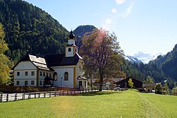 St. Joseph's Church | |
 Coat of arms | |
 Untertauern Location within Austria | |
| Coordinates: 47°18′10″N13°30′20″E / 47.30278°N 13.50556°E | |
| Country | Austria |
| State | Salzburg |
| District | St. Johann im Pongau |
| Government | |
| • Mayor | Johann Habersatter (SPÖ) |
| Area | |
• Total | 71.68 km2 (27.68 sq mi) |
| Elevation | 1,010 m (3,310 ft) |
| Population (2018-01-01) [2] | |
• Total | 466 |
| • Density | 6.5/km2 (17/sq mi) |
| Time zone | UTC+1 (CET) |
| • Summer (DST) | UTC+2 (CEST) |
| Postal code | 5561 |
| Area code | 06455 |
| Vehicle registration | JO |
| Website | www.untertauern.at |
Untertauern is a municipality in the district of St. Johann im Pongau in the Austrian state of Salzburg.

