
Simferopol is a city on the Crimean Peninsula which is, since the 2014 annexation of Crimea by the Russian Federation, the de facto capital city of the Republic of Crimea within the Russian Federation. De jure, it remains the capital city of the Autonomous Republic of Crimea within Ukraine. The status of Crimea is disputed between Russia and Ukraine as a result of the 2014 vote to join Russia, which was held during Russian military intervention, and the subsequent annexation. Simferopol is an important political, economic and transport hub of the peninsula, and serves as the administrative centre of both Simferopol Municipality and Simferopol District, though it does not belong to the district. Population: 332,317 .

The Kul Sharif Mosque located in Kazan Kremlin, was reputed to be – at the time of its construction – one of the largest mosques in Russia, and in Europe outside of Istanbul.

Aral, also known as Aralsk or Aral'sk, is a small city in south-western Kazakhstan, located in the oblast (region) of Kyzylorda. It serves as the administrative center of Aral District. Aral was formerly a fishing port and harbour city on the banks of the Aral Sea, and was a major supplier of fish to the neighboring region. Population: 29,987 ; 30,347.

Kyzylorda, formerly known as Kzyl-Orda, Ak-Mechet (Ак-Мечеть), Perovsk (Перовск), and Fort-Perovsky (Форт-Перовский), is a city in south-central Kazakhstan, capital of Kyzylorda Region and former capital of the Kazak ASSR from 1925 to 1929.

The Kazakh Autonomous Socialist Soviet Republic, abbreviated as Kazak ASSR and simply Kazakhstan, was an autonomous republic of the Soviet Union within the Russian Soviet Federative Socialist Republic (RSFSR) existing from 1925 until 1936.
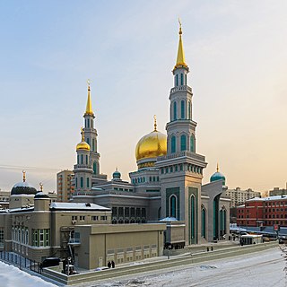
Moscow Cathedral Mosque is the main mosque of Moscow, Russia. It is located on Olimpiysky Avenue, close to the Olympic Stadium in the centre of the city.

Count Vasily Alekseevich Perovsky (1794–1857) was an imperial Russian general and statesman.

The Akhmad Kadyrov Mosque is located in Grozny, the capital of Chechnya. It is one of the largest mosques in Russia and is officially known as "The Heart of Chechnya".

Äcem Mosque ; is a prominent cathedral mosque in Kazan, Tatarstan, Russia. It is located in the southern part of the Old Tatar Quarter, a historic district populated by Tatars, and is one of about a dozen historical mosques in the district.

The Thousandth Anniversary of Islam Mosque or The Anniversary Mosque was built in Kazan, Tatarstan, Russia to commemorate the thousandth anniversary of the conversion of the Volga Bulgars in to Islam in 922. The alternative name of the mosque, and the most commonly used name, is The Mosque Across the Kaban, because most of Kazan's mosques are situated on the other side of the Kaban, where the Tatar community was traditionally located before the October Revolution. The part where the mosque was situated was inhabited predominantly by the Russian community.
White Mosque may refer to:

Safed-Bulan is a village and an archaeological reserve that is considered sacred for Muslims. Its population was 5,102 in 2009. The village is in an area in the north-western part of the Fergana Valley where the borders of Kyrgyzstan, Uzbekistan and Tajikistan meet. The settlement is at least one thousand years old and is mentioned in medieval, Arabic and Persian scriptures under the name Isbid Bulan.

Chernomorskoye or Chornomorske is an urban-type settlement and the administrative center of Chornomorske Raion in Crimea, a territory recognized by a majority of countries as part of Ukraine and incorporated by Russia as the Republic of Crimea. It is located on the northern edge of the Tarkhankut Peninsula. Population: 11,267 ; 11,643.

The Old Mosque of Moscow was built in 1823 to replace an earlier private mosque that had been destroyed by the 1812 fire. Its location is Bolshaya Tatarskaya Street in Zamoskvorechye, a neighbourhood formerly settled by the Tatars.

Khesht Masjed is a village in Belesbeneh Rural District, Kuchesfahan District, Rasht County, Gilan Province, Iran. At the 2006 census, its population was 935, in 297 families.
Khesht Masjed is a village in Pasikhan Rural District, in the Central District of Rasht County, Gilan Province, Iran. At the 2006 census, its population was 2,468, in 644 families.

The Russian conquest of Central Asia took place in the second half of the nineteenth century. The land that became Russian Turkestan and later Soviet Central Asia is now divided between Kazakhstan in the north, Uzbekistan across the center, Kyrgyzstan in the east, Tajikistan in the southeast and Turkmenistan in the southwest. The area was called Turkestan because most of its inhabitants spoke Turkic languages with the exception of Tajikistan, which speaks an Iranian language.

Submarine warfare in the Black Sea in World War II during 1943 involved engagements between submarines of the Soviet Black Sea Fleet attacking Axis merchantmen defended by Romanian and German naval warships, as well as and German U-boats attacking Soviet merchants on the eastern Black Sea. These engagements were a part of the Black Sea campaigns between Axis and Soviet naval forces.


