
Khunjerab Pass is a mountain pass in northern Pakistan that lies at an elevation of 4,693 metres (15,397 ft) above sea level. It is located in the Karakoram and holds a significant strategic position on the northern border of Pakistan, specifically in the Gilgit-Baltistan's Hunza and Nagar Districts. Additionally, it is positioned on the southwestern border of China, within the Xinjiang region.

Réunion possesses a network of highways, which cover a total distance of 2,784 km. Of that length, 2,187 km of the road system is paved. There are no roads going into the cirque of Mafate; thus transportation there has to take place by foot or helicopter.

The N3 is a national route in South Africa that connects Johannesburg and Durban, respectively South Africa's largest and third-largest cities. Johannesburg is the financial and commercial heartland of South Africa, while Durban is South Africa's key port and one of the busiest ports in the Southern Hemisphere and is also a holiday destination. Durban is the port through which Johannesburg imports and exports most of its goods. As a result, the N3 is a very busy highway and has a high volume of traffic.

The Johannesburg Ring Road is a set of freeways that circle the city of Johannesburg, South Africa and service the City of Johannesburg Metropolitan Municipality. The entire ring road is approximately 83 km long and was an e-toll highway from 3 December 2013 up until e-tolls were shut down in Gauteng on 12 April 2024.

National routes in South Africa are a class of trunk roads and freeways which connect major cities. They form the highest category in the South African route numbering scheme, and are designated with route numbers beginning with "N", from N1 to N18. Most segments of the national route network are officially proclaimed National Roads that are maintained by the South African National Roads Agency (SANRAL), but some segments are maintained by provincial or local road authorities.

The N1 is a national route in South Africa that runs from Cape Town through Bloemfontein, Johannesburg, Pretoria and Polokwane to Beit Bridge on the border with Zimbabwe. It forms the first section of the famed Cape to Cairo Road.

State Route 118 is a state highway in the U.S. state of California that runs west to east through Ventura and Los Angeles counties. It travels from State Route 126 at the eastern edge of Ventura immediately northwest of Saticoy, then through Saticoy, in Ventura County east to Interstate 210 near Lake View Terrace in Los Angeles. SR 118 crosses the Santa Susana Pass and the northern rim of the San Fernando Valley along its route.
Woodmead is mostly a commercial suburb in the northern part of Johannesburg, Gauteng, South Africa. Four highways meet here, the N1 Western Bypass, N1 Ben Schoeman Freeway, N3 Eastern Bypass, and the M1. The southern terminus of the R55 road is also located here. Access is off the Woodmead offramp to the M1. Several large business are located in Woodmead, including 3M, Ericsson, Accenture, Aspen Pharmacare and SAP.
Highway 60 is a provincial highway in the Canadian province of Saskatchewan. It runs from Highway 7 near Saskatoon to Pike Lake Provincial Park at Pike Lake. The speed limit is 90 km/h (55 mph). The highway is approximately 23 kilometres (14 mi) long.

Alberta Provincial Highway No. 54, commonly referred to as Highway 54, is an east–west highway located in central Alberta. It is 70 kilometres (43 mi) in length, starting at Highway 22, 8 kilometres (5.0 mi) west of the Village of Caroline, and ending at exit 365 of Highway 2 at the south end of the Town of Innisfail.

State Route 307 (SR 307) is an east–west state highway in the northeastern portion of the U.S. state of Ohio. Its western terminus is at State Route 528 on the southern boundary of Madison, and its eastern terminus is at State Route 193 nearly 7 miles (11 km) southeast of Jefferson.
Purano Jhangajholi is a village development committee in Sindhuli District in the Janakpur Zone of south-eastern Nepal. At the time of the 1991 Nepal census, it had a population of 4,474 people living in 816 individual households. The village is notable for a highway reportedly among Asia's most dangerous; small mirrors cover its retaining wall to draw on Seti Devi Mata, a deity, to prevent accidents.

Türkmenbaşy Ruhy Mosque, or Gypjak Mosque, is a mosque in Gypjak, Turkmenistan and the resting place for Saparmurat Niyazov, the leader of Turkmenistan from 1985 to 2006. The mosque is located about 7 kilometres (4.3 mi) west of the capital, Ashgabat, on the M37 highway.

UMshwathi Local Municipality is situated in UMgungundlovu District Municipality (UMDM) which is in the foothills of the province of KwaZulu-Natal, about 120 km northwest of Durban, geographically located between the N2 and the N3 highways. The municipality is the largest Municipality in the largest district of KZN out of the seven Local Municipalities which form UMDM.
Tamerna Djedida is a village in the commune of Sidi Amrane, in Djamaâ District, El M'Ghair Province, Algeria. The village is located along a short road on the western side of the N3 highway, 10 kilometres (6.2 mi) south of Djamaa.
Arfiane El Bared is a village in the commune of Tendla, in Djamaâ District, El M'Ghair Province, Algeria. The village is located just to the east of the N3 highway, 14 kilometres (8.7 mi) north of Djamaa, on the Biskra-Touggourt railway. The local road W303 leads through the village from the N3 towards Tendla.
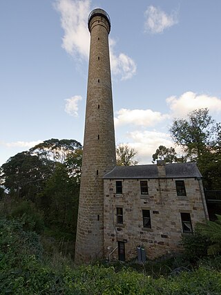
The Shot Tower is a historic sandstone shot tower situated in Taroona, Tasmania, Australia. The tower held the title of tallest building within the Australian colonies between 1870 and 1875 and remained the tallest structure in Tasmania until 1960, when it was surpassed by the Mount Wellington broadcast tower. The Shot Tower is recognised as the tallest cylindrical sandstone tower in the Southern Hemisphere. The building is listed on the Tasmanian Heritage Register and was previously listed on the former Register of the National Estate.
Atlas Obscura is an American-based travel and exploration company. It was founded in 2009 by author Joshua Foer and documentary filmmaker/author Dylan Thuras. It catalogs unusual and obscure travel destinations via professional and user-generated content, operates group trips to destinations around the world, produces a daily podcast, as well as books, TV and film. The brand covers a number of topics including history, science, food, and obscure places.
Kolkja is a small borough in Peipsiääre Parish, Tartu County, in southeastern Estonia. As of the 2011 census, the settlement's population was 277.
Whitecap Dakota First Nation is a Dakota First Nations band government whose reserve is located 26 km (16 mi) south of Saskatoon, Saskatchewan, Canada. Governing the Whitecap Indian Reserve No. 94, historically referred to as the Moose Woods Sioux Reserve, it is bordered by the Rural Municipality of Dundurn No. 314 and located along Highway 219 between the South Saskatchewan River and CFAD Dundurn.