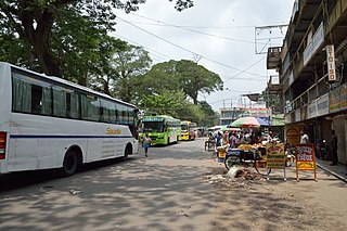
Petrapole is the Indian side of Petrapole-Benapole border checkpoint between India and Benapole of Bangladesh, on the Bangladesh-India border, near Bongaon in North 24 Parganas district of West Bengal. Petrapole border is the only land port in south Bengal. It is also the largest land customs station in Asia.

Benapole is a township in Sharsha Upazila in the Jessore District of Bangladesh. The Petrapole Customs station of India is situated across the border and since 1971, many people have travelled between Bangladesh and India through Benapole Customs / Land port station. The railway link between Bangladesh and India through Benapole was discontinued when war broke out between Pakistan and India in September 1965.

Sharsha is an upazila of Jessore District in the Division of Khulna, Bangladesh.

Goalundo Ghat is a small town and pourasabha in Goalandaghat Upazila, Rajbari District, Dhaka Division, Bangladesh, South Asia. There are two railway stops one at Goalundo Ghat and one at Goalundo Bazar. The town has an area of 4.86 km2 and a population of 22,000 inhabitants.
Transport between India and Bangladesh bears much historical and political significance for both countries, which possessed no ground transport links for 43 years, starting with the partition of Bengal and India in 1947. The Kolkata–Dhaka Bus (1999) and the Dhaka–Agartala Bus (2001) are the primary road links between the two countries; a direct Kolkata-Agartala running through Dhaka, the capital of Bangladesh is being developed by both countries. The Maitree Express was launched to revive a railway link between Kolkata and Dhaka that had been shut for 43 years.
Radhikapur railway station serves Radhikapur in the Uttar Dinajpur district, West Bengal, India. It is an active rail transit system on the Bangladesh–India border. It is an India–Bangladesh land border checkpoint and has a land customs station for movement of goods. Both Indian and Bangladesh governments have been trying to increase connectivity through Radhikapur.

The Barharwa–Azimganj–Katwa loop is a railway line connecting Barharwa on the Sahibganj loop and Katwa. Together with the Bandel–Katwa line, which connects this line to Bandel Junction on the Howrah–Bardhaman main line, it is also known as the B.B Loop Line. This 170 kilometres (110 mi) line is under the jurisdiction of Eastern Railway. The majority of this line passes through the Purba Bardhaman and Murshidabad districts, in the Indian state of West Bengal, and lies on the west bank of the Bhagirathi river.

Jessore Road is an International road connecting Shyambazar through Dum Dum in Kolkata, India to Jessore in Bangladesh. While the Dum Dum-Barasat sector is now part of NH 12, the Barasat-Petrapole sector is now part of NH 112. It continues in Bangladesh as N706 from Benapole to Jessore. The whole road is the part of Asian Highway 1. The road acts as a major link between places in and around Kolkata, especially Netaji Subhash Chandra Bose International Airport and Barasat. The road meets commuter (suburban) rail link at Barasat Junction railway station. Metro stations on this road include Shyambazar and Belgachia.

The N8 is a Bangladeshi National Highway between the capital Dhaka and the town of Patuakhali. It starts from the Jatrabari interchange and ends at the Patuakhali bridge.
The N4 is a Bangladeshi national highway connecting Joydebpur near the Bangladeshi capital Dhaka, Tangail and Jamalpur. It is part of AH2 and AH41 in the Asian Highway Network.

The N3 or Dhaka–Mymensingh Highway is a national highway in Bangladesh. It connects the Bangladeshi capital city of Dhaka with the city of Mymensingh in the north.

The Bangladesh, Bhutan, India, Nepal (BBIN) Initiative is a subregional architecture of countries in Eastern South Asia, a subregion of South Asia. It meets through official representation of member states to formulate, implement and review quadrilateral agreements across areas such as water resources management, connectivity of power, transport, and infrastructure.

The Petrapole-Benapole joint retreat ceremony was inaugurated on 6 November 2013 by the Indian Home Minister at Integrated Check Post (ICP) Petrapole-Benapole in the presence of the Home Minister of Bangladesh. It is a daily military exercise, similar to the Wagah Border ceremony, and engages soldiers of Border Security Force (India) and the Border Guards Bangladesh.

Asian Highway 41 (AH41) is a route of the Asian Highway Network, running 948 kilometres (589 mi) from Teknaf in Chittagong Division, Bangladesh to Mongla in Khulna Division, Bangladesh.

The Republic of India shares borders with several sovereign countries; it shares land borders with China, Bhutan, Nepal, Pakistan, Bangladesh, and Myanmar. Bangladesh, Myanmar, and Pakistan share both land borders as well as maritime borders, while Sri Lanka shares only a maritime border through Ram Setu. India's Andaman and Nicobar Islands share a maritime border with Thailand, Myanmar, and Indonesia.

The Sealdah–Bangaon line is a 78 km (48 mi) long broad gauge railway line that connects the Sealdah railway station of Kolkata with Bangaon of North 24 Parganas in the Indian state of West Bengal. Once a part of the old Calcutta–Jessore–Khulna line, today it is a busy suburban section of the Kolkata Suburban Railway. It is under the jurisdiction of the Sealdah railway division of the Eastern Railway zone of Indian Railways.

The Benapole Border Crossing also known as the Petrapole Crossing is an international border crossing between Benapole, Jessore, Bangladesh, and Petrapole, North 24 Parganas, West Bengal, India.

The N706 or Jessore–Benapole highway or historically known as Jessore Road is a National Highway in Bangladesh. It connects Doratana, Jessore to Benapole Border Crossing at the international border with India where it meets with NH 112.

N804 or Dhaka- Faridpur Highway is a Bangladeshi national highway connecting Faridpur to Bhanga. It starts at Bhanga Interchange in Bhanga Upazila and ends at Bangabandhu Square at Faridpur.

N707 or Jessore City north-south connecting road is a national highway. This road connect two side of the city of Jessore. The road starts from Palbari intersection from where it is known as Mashiur Rahman Road until Daratana Interchange, and from Daratana Interchange to Manihar Intersection where it known as Rabindranath Tagore Road. Lastly from Manihar Intersection to Murali intersection, it known as Khulna Road.
