Related Research Articles

A weather station is a facility, either on land or sea, with instruments and equipment for measuring atmospheric conditions to provide information for weather forecasts and to study the weather and climate. The measurements taken include temperature, atmospheric pressure, humidity, wind speed, wind direction, and precipitation amounts. Wind measurements are taken with as few other obstructions as possible, while temperature and humidity measurements are kept free from direct solar radiation, or insolation. Manual observations are taken at least once daily, while automated measurements are taken at least once an hour. Weather conditions out at sea are taken by ships and buoys, which measure slightly different meteorological quantities such as sea surface temperature (SST), wave height, and wave period. Drifting weather buoys outnumber their moored versions by a significant amount.

A weather satellite or meteorological satellite is a type of Earth observation satellite that is primarily used to monitor the weather and climate of the Earth. Satellites can be polar orbiting, or geostationary.
The National Weather Service (NWS) is an agency of the United States federal government that is tasked with providing weather forecasts, warnings of hazardous weather, and other weather-related products to organizations and the public for the purposes of protection, safety, and general information. It is a part of the National Oceanic and Atmospheric Administration (NOAA) branch of the Department of Commerce, and is headquartered in Silver Spring, Maryland, within the Washington metropolitan area. The agency was known as the United States Weather Bureau from 1890 until it adopted its current name in 1970.

NOAA Weather Radio (NWR), also known as NOAA Weather Radio All Hazards, is an automated 24-hour network of VHF FM weather radio stations in the United States that broadcast weather information directly from a nearby National Weather Service office. The routine programming cycle includes local or regional weather forecasts, synopsis, climate summaries or zone/lake/coastal waters forecasts. During severe conditions the cycle is shortened into: hazardous weather outlooks, short-term forecasts, special weather statements or tropical weather summaries. It occasionally broadcasts other non-weather related events such as national security statements, natural disaster information, environmental and public safety statements, civil emergencies, fires, evacuation orders, and other hazards sourced from the Federal Communications Commission's (FCC) Emergency Alert System. NOAA Weather Radio uses automated broadcast technology that allows for the recycling of segments featured in one broadcast cycle into another and more regular updating of segments to each of the transmitters. It also speeds up the warning transmitting process.
The National Ocean Service (NOS) is an office within the U.S. Department of Commerce, National Oceanic and Atmospheric Administration (NOAA). It is the responsible for preserving and enhancing the nation's coastal resources and ecosystems along approximately 95,000 miles (153,000 km) of shoreline, that is bordering 3,500,000 square miles (9,100,000 km2) of coastal, Great Lakes, and ocean waters. Its mission is to "provide science-based solutions through collaborative partnerships to address the evolving economic, environmental, and social pressures on our oceans and coasts." Its projects focus on working to ensure the safe and efficient marine transportation, promoting the protection of coastal communities, conserving marine and coastal places. NOS employs 1,700 scientists, natural resource managers, and specialists in many different fields. The National Ocean Service was previously also known as the National Ocean Survey until it was renamed in 1983.
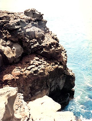
Ka Lae, also known as South Point, is the southernmost point of the Big Island of Hawaii and of the 50 United States. The Ka Lae area is registered as a National Historic Landmark District under the name South Point Complex. The area is also known for its strong ocean currents and winds and is the home of a wind farm.

The Mauna Loa Observatory (MLO) is an atmospheric baseline station on Mauna Loa, on the island of Hawaii, located in the U.S. state of Hawaii.
The National Severe Storms Laboratory (NSSL) is a National Oceanic and Atmospheric Administration (NOAA) weather research laboratory under the Office of Oceanic and Atmospheric Research. It is one of seven NOAA Research Laboratories (RLs).
Neron or Néron may refer to:

In meteorology and climatology, a mesonet, portmanteau of mesoscale network, is a network of automated weather and, often also including environmental monitoring stations, designed to observe mesoscale meteorological phenomena and/or microclimates.
The Community Collaborative Rain, Hail and Snow Network, or CoCoRaHS, is a network of volunteer weather observers in the United States, Canada, and the Bahamas that take daily readings of precipitation and report them to a central data store over the Internet. The program is an example of citizen science.

The Volunteer Air Observers Corps (VAOC) was an Australian air defence organisation of World War Two. The VAOC was formed in December 1941 to support the Royal Australian Air Force (RAAF) with its main roles of sighting and observing aircraft over Australia. The VAOC swiftly established thousands of Observation Posts (OP) across the country and provided information to the RAAF's regional air control posts.

Airport weather stations are automated sensor suites which are designed to serve aviation and meteorological operations, weather forecasting and climatology. Automated airport weather stations have become part of the backbone of weather observing in the United States and Canada and are becoming increasingly more prevalent worldwide due to their efficiency and cost-savings.
The Group on Earth Observations (GEO) coordinates international efforts to build a Global Earth Observation System of Systems (GEOSS). It links existing and planned Earth observation systems and supports the development of new ones in cases of perceived gaps in the supply of environment-related information. It aims to construct a global public infrastructure for Earth observations consisting of a flexible and distributed network of systems and content providers.
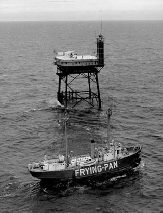
Frying Pan Shoals Light Station is a decommissioned Coast Guard lighthouse located near the end of the Frying Pan Shoals 32 miles (51 km) SE of Bald Head Island, North Carolina. The Frying Pan Tower™ rises 135' above the Atlantic Ocean is being restored by volunteers through FPTower Inc., a 501(c)3 nonprofit whose mission is to help provide safety to mariners and the local sea life as well as providing an on-site facility for environmental research, and to live stream cameras of above and below the ocean. Several universities and governmental agencies have used the tower's unique location to perform vital research over the last decade as it is being restored.
Circumarctic Environmental Observatories Network (CEON) is a network of terrestrial and freshwater observation platforms, science experts and network partners promoting the collection and dissemination of environmental data from the Arctic. CEON observation platforms include land and freshwater observatories, research infrastructures, former research sites where retrospective analyses are being or can be undertaken, data and image archive centers and community monitoring programs.

National Weather Service Lincoln, Illinois also known as National Weather Service Central Illinois is a weather forecast office responsible for monitoring weather conditions for 35 counties in Central and Southeastern Illinois. The Central Illinois office initially consisted of two forecast offices in Peoria and Springfield until the current location in Lincoln became the sole local forecast office in 1995. Federal meteorology offices and stations in the region date back to the 19th century when the Army Signal Service began taking weather observations using weather equipment at the Springer Building in Springfield. Since that time the presence of the National Weather Service greatly increased with the installation of new weather radars, stations and forecast offices. The current office in Lincoln maintains a WSR-88D (NEXRAD) radar system, and Advanced Weather Interactive Processing System (AWIPS) that greatly improve forecasting in the region. Lincoln is in charge of weather forecasts, warnings and local statements as well as aviation weather.
The NOAA National Operational Model Archive and Distribution System (NOMADS) is a Web-services based project providing both real-time and retrospective format independent access to climate and weather model data.
Automated Weather Source (AWS) was a partnership and later a corporation founded in 1992 by James Michael "Mike" Bailey and Charles "Topper" Shutt of Montgomery County, Maryland, whose purpose was to create a network of weather stations located at public schools and recreational facilities throughout the Mid-Atlantic region of the United States.
The NOAA Cooperative Observer Program (COOP) is a citizen weather observer network run by the U.S. National Weather Service (NWS) and National Centers for Environmental Information (NCEI). Over 8,700 volunteers from the fifty states and all territories report at least daily a variety of weather conditions such as daily maximum and minimum temperatures, 24-hour precipitation totals, including snowfall, and significant weather occurrences throughout a day that are recorded via remarks in observer logs. Some stations also report stream stage or tidal levels.
References
| | This article about atmospheric science is a stub. You can help Wikipedia by expanding it. |