
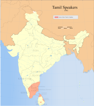
Tamil Nadu is one of the 28 states of India. Its capital and largest city is Chennai. Tamil Nadu lies in the southernmost part of the Indian subcontinent and is bordered by the union territory of Puducherry and the South Indian states of Kerala, Karnataka, and Andhra Pradesh. It is bounded by the Eastern Ghats on the north, by the Nilgiri Mountains, the Meghamalai Hills, and Kerala on the west, by the Bay of Bengal in the east, by the Gulf of Mannar and the Palk Strait on the southeast, and by the Indian Ocean on the south. The state shares a maritime border with the nation of Sri Lanka.

Chamarajanagar is the southernmost district in the state of Karnataka, India. It was carved out of the original larger Mysore District in the year 1998. Chamarajanagar town is the headquarters of this district.
Ariyalur district is an administrative district in the state of Tamil Nadu in India. The district headquarters is located at Ariyalur. The district encompasses an area of 1,949.31 km².
Dharmapuri(officially known as Tharumapuri) is a city in the western part of Tamil Nadu, India. The city is located at 126 km from Bangalore, 200 km from Coimbatore, 260 km from Mysore, and 300 km from Chennai. It is located between latitudes N 11 47’ and 12 33’ and longitudes E 77 02’ and 78 40’. The total geographical area of Tharumapuri District is 4497.77 km2, that is, 3.46% of Tamil Nadu. It is one of top leading Mango cultivator and producer of state.

Perambalur is an administrative district in the state of Tamil Nadu, India. The district headquarters is located at Perambalur. The district occupies an area of 1,752 km² and had a population of 565,223 with a sex-ratio of 1,003 females for every 1,000 males in 2011.

Kongu Nadu is a region comprising the western part of Tamil Nadu. In the ancient Tamilakam, it was the seat of the Chera kings, bounded on the east by Tondai Nadu, on the south-east by Chola Nadu and on the south by Pandya Nadu regions.

{{More citations needed|date=January 2019}}

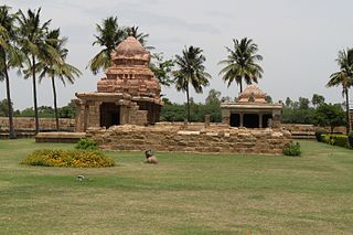
Thoothukudi District is one of the 38 districts of Tamil Nadu state in southern India. The district was formed by bifurcation of Tirunelveli district on 20 October 1986. Thoothukudi is the capital and the main town of the district. The district is known for pearl cultivation, with an abundance of pearls being found in the seas offshore. It was formerly ruled by one of the oldest kingdoms in India, the Pandyan Dynasty with the port of Korkai through which trade with Rome happened. The archaeological site at Adichanallur holds the remains of the ancient Tamil civilisation.

Gangavalli is a panchayat town in Salem district in the state of Tamil Nadu, India.
Puliyankadu is a town and a municipality in Viluppuram district in the Indian state of Tamil Nadu. It is the second largest town in Villupuram District after the headquarters town Villupuram. Important roads from north to south Tamil Nadu pass through Tindivanam and similarly from west to east.

Thanjavur District is one of the 38 districts of the state of Tamil Nadu, in southeastern India. Its headquarters is Thanjavur. The district is located in the delta of the Cauvery River and is mostly agrarian. As of 2011, Thanjavur district had a population of 2,405,890 with a sex-ratio of 1,035 females for every 1,000 males.

The Government of Tamil Nadu is the governing authority for the Indian state of Tamil Nadu. It is seated at Fort St George, Chennai. The legislature of Tamil Nadu was bicameral until 1986, when it was replaced by a unicameral legislature, like most other states in India.
Puthanampatti is a village located in Thuraiyur Taluk, Tiruchirappalli district of Tamil Nadu, India. Puthanampatti village is located approximately 35km from Tiruchirappalli. Agriculture is the backbone of their economy. This village is located in South India and is known for it's rich and unique culture.

Tiruppur District is a district of the Indian state Tamil Nadu, formed in 22 February 2009. Dharapuram was the Largest Taluk By Area In Tiruppur District. The district is well-developed and industrialized. The Tiruppur banian industry, the cotton market,kangeyam bull and the famous uthukkuli butter, among other things, provide for a vibrant economy. The city of Tiruppur is the administrative headquarters for the district. As of 2011, the district had a population of 2,479,052 with a sex-ratio of 989 females for every 1,000 males.
National Highway 136, commonly referred to as NH 136, is a national highway of India. It comes under Ministry of Road Transport and Highways, Government of India. It is a secondary route of National Highway 36. NH-136 traverses the state of Tamil Nadu in India.
Madurantakam taluk is a taluk of Chengalpattu district of the Indian state of Tamil Nadu. The headquarters of the taluk is the town of Madurantakam. Madurantakam taluk is bounded by Chengalpattu taluk in north, Uthiramerur taluk of Kanchipuram district in West, Thirukklaukkundram Taluk in north east and Tindivanam lauk of Villupuram district in south.
Naduvalur (West) is a village in the Udayarpalayam taluk of Ariyalur district, Tamil Nadu, India.
Gangavalli block is a revenue block in the Salem district of Tamil Nadu, India. It has a total of 14 panchayat villages. They are:
- Anaiyampatti
- Belur
- Goodamalai
- Jangamasamudram
- Kadambur
- Kondayampalli
- Krishnapuram
- Manmalai
- Naduvalur
- Nagiyampatti
- Odhiyathur
- Pachamalai
- Thagarapudur
- Ulipuram
Puduvoyal is a village panchayat located in the Thiruvallur district of Indian state of Tamil Nadu.
The Tamil Nadu diaspora also known as Madrasi diaspora comprises people who have emigrated from South Indian state of Tamil Nadu, to other non-Tamil Indian states and other countries, and people of Tamil Nadu descent born or residing in other non-Tamil Indian states and other countries.