Related Research Articles

Pokhara is a metropolitan city located in central Nepal, which serves as the capital of Gandaki Province and is declared as the tourism capital of Nepal. It is the second most populous city of the nation after Kathmandu, with 599,504 inhabitants living in 120,594 households as of 2021. It is the country's largest metropolitan city in terms of area. The city also serves as the headquarters of Kaski District. Pokhara is located 200 kilometres west of the capital, Kathmandu. The city is on the shore of Phewa Lake, and sits at an average elevation of approximately 822 m above sea level. The Annapurna Range, with three out of the ten highest peaks in the world—Dhaulagiri, Annapurna I and Manaslu—is within 15–35 mi (24–56 km) aerial range from the valley.
Kaski District, a part of Gandaki Province, is one of the seventy-seven districts of Nepal. The name is disambiguated from Kaskikot, the ancient Kaski Kingdom.

Syangja District is a part of Gandaki Province, and is one of the seventy-seven districts of Nepal. Its headquarter is Putalibazar with a diverse population including Brahmin, Chhetri, Magar, Dalit and Gurung communities. Syangja is home to attractions like the ancient temples of Garaunsur and Akala, scenic viewpoints such as Panchase, and the historical town of Waling, making it a growing eco-tourism destination. The economy is primarily based on agriculture, with rice, maize, millet, and fruits like oranges being widely cultivated. Syangja is the leading Orange producer in nepal with 22,000 tons in 2023. The district has several educational institutions, and many residents pursue higher education in cities like Pokhara and Kathmandu. Well-connected by highways to major cities like Pokhara and Butwal, Syangja offers a blend of natural beauty, cultural diversity, and historical importance. The district covers an area of 1,164 km2 (449 sq mi) and has a population of 254,965.

The Prithvi Highway or NH04 (Nepali: पृथ्वी राजमार्ग) is a 174-kilometre-long (108 mi) highway connecting Naubise of Tribhuvan Highway, 26 km from Kathmandu, the capital of Nepal, and Prithivi Chowk, Pokhara, a tourist city in the western part of Nepal.

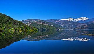
Phewa Lake or Phewa Tal is a freshwater lake in Nepal formerly called Baidam Tal located in the south of the Pokhara Valley that includes Pokhara city and parts of Sarangkot and Kaskikot. It is the second largest lake in Nepal and the largest in Gandaki Province after the Rara lake in comparison to Nepal's water bodies. It is the most popular and most visited lake in Nepal. Phewa lake is located at an altitude of 742 m (2,434 ft) and covers an area of about 5.7 km2 (2.2 sq mi). It has an average depth of about 8.6 m (28 ft) and a maximum depth of 24 m (79 ft). The maximum water capacity of the lake is approximately 43,000,000 cubic metres (35,000 acre⋅ft). The Annapurna range on the north is only about 28 km away from the lake. The lake is also famous for the reflection of mount Machhapuchhre and other mountain peaks of the Annapurna and Dhaulagiri ranges on its surface. The Tal Barahi Temple is situated on an island in the lake. It is located 4 km from the city's centre Chipledhunga.
Thulo Pokhara is a small town in Arghakhanchi District in the Lumbini Zone of southern Nepal. At the time of the 1991 Nepal census, it had a population of 3,469 and had 711 houses in the town.
Kristinachnechaur is a former Village Development Committee south of Pokhara in Kaski District in the Gandaki Zone of northern-central Nepal. In 2015, it was annexed to Pokhara. At the 1991 Nepal census, it had a population of 5,757 persons in 1,145 individual households.

Sarangkot is Ward 18 of Pokhara, Kaski District, Nepal, after it was merged into the city in 2015. It is a popular tourist destination for those who arrive in Pokhara. At the 1991 Nepal census it had a total population of 5,060 with 1,010 individual households.

The Western Development Region was one of Nepal's five development regions. It was located in the west-central part of the country, with its headquarters located in Pokhara. This Development Region was divided into three parts, from south to north in order of increasing altitude: Terai, Hilly and Himalayan. Mustang, Damodar, Peri, Thaple, Ganesh are among the major ranges of the Himalayas.

The Pokhara Rangasala is a multi-purpose stadium in Pokhara, Gandaki Province, Nepal. It has a capacity of 18,500 spectators. The venue is located to the south of Pokhara at Rambazaar on the eastern bank of Seti river.
Khareha is a small village in Parbat District in Gandaki Province of western Nepal. Khareha is located on the cross side of Pokhara Baglung Highway. It is one of the small wards of Shiwalaya Village Development Committee Kushma Parbat.

Mai Pokhari is a wetland in Ilam District of Nepal that was designated a Ramsar site on 28 October 2008. It is a pilgrimage center for both Hindus and Buddhists. The lake within the wetland which reflects emerald waters has a circumference of about 1 kilometre (0.62 mi) and boats are operated. On the periphery of the lake there is the Maipokhari Botanical Garden of horticultural and ecological importance which houses a rock garden, an orchid house, plants collected from many regions of eastern Nepal, and a green house.
Galkot is a municipality in Baglung district of Gandaki province of Nepal. It consists of several VDCs. Nearby cities include Gulmi and Pokhara. Its geographic coordinates are 28°13'24"N 83°25'29"E.

Mahendrapul is the financial hub and the busiest high street of Pokhara. It is one of the oldest and busiest marketplaces in the city and one of its central locations. It is named after the Mahendrapul Bridge over Seti River. The bridge links Ranipauwa to Mahendrapool.
The Bhimsen Mandir or Bhimsen Temple is an 18th-century Hindu temple located in Nalamukh, Pokhara, Nepal. Bhimsen is the patron deity of people of Newari ethnicity. The temple like many in Nepal has erotic carvings on the struts.
Bhairab Tole is one of the oldest areas of Pokhara where people first settled in the valley. This was also an area of prominent commercial activities before 1960.

The Bat Cave is a solutional cave in the Kaski District in Pokhara, Nepal. It is known for a habitat of Horseshoe bats inside the cave, over the walls and ceiling. The cave is formed of limestone. It is a show cave and one of the most popular tourist destinations in Pokhara.
The Kali Khola is a tributary of the Seti Gandaki River in Nepal. It joins the Seti Gandaki in the ward of Bagar in Pokhara in central Nepal.
Furse Khola is a tributary of the Seti Gandaki River in Pokhara, Nepal. It joins the Seti Gandaki to the south of Pokhara International Airport.

Gangapurna is a mountain in Gandaki Province, Nepal. It is part of the Annapurna mountain range in north-central Nepal at an elevation of 7,455 metres (24,459 ft) and with the prominence of 563 metres (1,847 ft). It was first ascended in 1965 by a German expedition via its south face and east ridge. Gangapurna is entirely located in the Annapurna Conservation Area.
References
- ↑ Gurung, Harka B. (1980). Vignettes of Nepal. Sajha Prakashan.
- ↑ Planet, Lonely; Mayhew, Bradley; Brown, Lindsay; Stiles, Paul (2018-07-01). Lonely Planet Nepal. Lonely Planet. ISBN 978-1-78701-925-6.
- ↑ Shrivastava, Virendra Kumar (1988). Commercial Activities and Rural Development in South Asia: A Geographical Study : Proceedings of the International Conference of the IGU Study Group on Geography of Commercial Activities, Gorakhpur, 1985. Concept Publishing Company. ISBN 978-81-7022-194-4.
28°13′N83°59′E / 28.217°N 83.983°E
| | This article about a location in Gandaki Province of Nepal is a stub. You can help Wikipedia by expanding it. |