Related Research Articles

The Pribilof Islands are a group of four volcanic islands off the coast of mainland Alaska, in the Bering Sea, about 200 miles (320 km) north of Unalaska and 200 miles (320 km) southwest of Cape Newenham. The Siberian coast is roughly 500 miles (800 km) northwest. About 77 square miles (200 km2) in total area, they are mostly rocky and are covered with tundra, with a population of 572 as of the 2010 census.

The Alaska Time Zone observes standard time by subtracting nine hours from Coordinated Universal Time (UTC−09:00). During daylight saving time its time offset is eight hours (UTC−08:00). The clock time in this zone is based on mean solar time at the 135th meridian west of the Greenwich Observatory.

Mitkof Island is an island in the Alexander Archipelago in southeast Alaska between Kupreanof Island to the west and the Alaskan mainland to the east. It is approximately 16 km (9.9 mi) wide and 28 km (17 mi) long with a land area of 539.7 km2 (208.4 sq mi), making it the 30th largest island in the United States. Much of the island is managed as part of the Tongass National Forest.
Kruzof Island is an island in the Alexander Archipelago in southeastern Alaska at 57°10′14″N135°40′29″W. It is about 16 km (10 mi) west of Sitka, and is part of the City and Borough of Sitka. It was named in 1805 by Captain U.T. Lisianski as Crooze Island, after a Russian Admiral. It hosts the region's only volcano, Mount Edgecumbe.
Japonski Island is a small island in the city of Sitka in the Alexander Archipelago of southeastern Alaska, United States. It lies across the Sitka Channel from Sitka's central business district.
Etolin Island is an island in the Alexander Archipelago of southeastern Alaska, United States at 56°05′52″N132°21′37″W. It is between Prince of Wales Island, to its west, and the Alaska mainland, to its east. It is southwest of Wrangell Island. It was first charted in 1793 by James Johnstone, one of George Vancouver's officers during his 1791-95 expedition. He only charted its southwest and east coasts, not realizing it was an island. It was originally named Duke of York Island but was renamed by the United States after the Alaska Purchase. It is named after Adolf Etolin, governor of the Russian American colonies from 1840 to 1845.
The Saint Lazaria Wilderness or St. Lazaria Island is a nesting bird colony located twenty miles (32 km) west of Sitka, Alaska and is a part of the Gulf of Alaska unit of the Alaska Maritime National Wildlife Refuge. It is located in Sitka Sound, just south of Kruzof Island, and within the limits of the City and Borough of Sitka, Alaska. The island's name is Kanasx'ée in the Tlingit language.
Cozian Reef or Nikolas Rock is located just above the northern tip of Baranof Island in Peril Strait which is in the Panhandle of the U.S. state of Alaska.

Hagemeister Island is an uninhabited island in the U.S. state of Alaska, located on the north shore of Bristol Bay at the entrance to Togiak Bay.

Sitka Sound is a body of water near the city of Sitka, Alaska. It is bordered by Baranof Island to the south and the northeast, by Kruzof Island to the northwest and by the Pacific Ocean to the southwest. During the early 19th century it was a major locus of the maritime fur trade.
Zarembo Island is an island in the Alexander Archipelago of southeastern Alaska, United States. It lies directly south of Mitkof Island and northwest of Etolin Island. To the northwest is Kupreanof Island and to the southwest is Prince of Wales Island. It has a land area of 183.14 square miles, making it the 34th largest island in the United States. It has no permanent resident population. It was first charted in 1793 by James Johnstone, one of George Vancouver's officers during his 1791-95 expedition. He only charted its north, west, and south coasts, not realizing it was an island. The island is named after Dionysius Zarembo, a Polish employee of the Russian American Company and explorer of Alaska. Usually known as Dionysius Zarembo, he was captain of the Russian-American Company ship Chichagof during the foundation of the Redoubt San Dionisio, named for his name-saint, a fortification at present-day Wrangell which was established to forestall encroachment on the Stikine region by the Hudson's Bay Company.
Woronkofski Island is an island in the Alexander Archipelago of southeastern Alaska, United States. It is separated from Wrangell Island to the east by Zimovia Strait, just west of the city of Wrangell; to the west it is separated from Zarembo Island by Stikine Strait, and to the south from Etolin Island by Chichagof Pass. Woronkofski Island has a land area of 59.382 km2 and was unpopulated at the 2000 census. The city of Wrangell is exploring the possibility of utilizing Sunrise Lake on the island for hydroelectrical power and drinking water.

ALSIB was the Soviet Union portion of the Alaska-Siberian air road receiving Lend-Lease aircraft from the Northwest Staging Route. Aircraft manufactured in the United States were flown over this route for World War II combat service on the Eastern Front.

Wrangell Island is an island in the Alexander Archipelago in the Alaska Panhandle of southeastern Alaska. It is 48 kilometres long and 8 to 23 kilometres wide. It has a land area of 544.03 square kilometres, making it the 29th largest island in the United States. Wrangell is separated from the mainland by the narrow Blake Channel.

The Aleutian Islands, also called the Aleut Islands or Aleutic Islands and known before 1867 as the Catherine Archipelago, are a chain of 14 large volcanic islands and 55 smaller islands. Most of the Aleutian Islands belong to the U.S. state of Alaska, but some belong to the Russian federal subject of Kamchatka Krai. They form part of the Aleutian Arc in the Northern Pacific Ocean, occupying a land area of 6,821 sq mi (17,666 km2) and extending about 1,200 mi (1,900 km) westward from the Alaska Peninsula toward the Kamchatka Peninsula in Russia, and act as a border between the Bering Sea to the north and the Pacific Ocean to the south. Crossing longitude 180°, at which point east and west longitude end, the archipelago contains both the westernmost part of the United States by longitude and the easternmost by longitude. The westernmost U.S. island in real terms, however, is Attu Island, west of which runs the International Date Line. While nearly all the archipelago is part of Alaska and is usually considered as being in the "Alaskan Bush", at the extreme western end, the small, geologically related Commander Islands belong to Russia.

Baranof Island is an island in the northern Alexander Archipelago in the Alaska Panhandle, in Alaska. The name Baranof was given in 1805 by Imperial Russian Navy captain U. F. Lisianski to honor Alexander Andreyevich Baranov. It was called Sheet’-ká X'áat'l by the native Tlingit people. It is the smallest of the ABC islands of Alaska. The name "Baranof" was given to the island in 1805, by the Imperial Russian Navy Captain U.F. Lisianski, in honor of the Russian Alaskan governor Alexander Andreyevich Baranov. The indigenous group native to the island, the Tlingit, named the island Shee Atika. Baranof island is home to a diverse ecosystem, which made it a prime location for the fur trading company, the Russian American Company. Russian occupation in Baranof Island impacted not only the indigenous population as well as the ecology of the island, but also led to the United States' current ownership over the land.
Biorka Island is an island near Sitka, Alaska. The National Weather Service has a radar there. The island is also a popular spot to watch sealions. Thus, a 2005 proposal by the State of Alaska to give a parcel of 438 acres (177 ha) on the island to the University of Alaska stirred up a controversy.
Cannon Island is a small island in Sitka, Alaska, United States. It is connected to Baranof Island and Sitka by a gravel causeway, Cannon Island Drive. The island was named "Pushki" by explorer Ivan Vasilyev in 1809.
References
- ↑ U.S. Geological Survey Geographic Names Information System: Nameless Island (Alaska)
- ↑ Orth, Donald J. (1967). Dictionary of Alaska Place Names. U.S. Government Printing Office. p. 672.
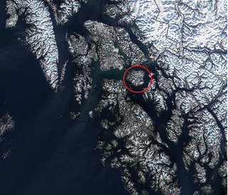
Coordinates: 56°47′09″N135°27′36″W / 56.785842°N 135.460050°W
| | This article about a location in the City and Borough of Sitka, Alaska is a stub. You can help Wikipedia by expanding it. |