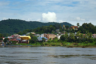
Houayxay, is a district in Bokeo Province, Laos, on the border with Thailand. Ban Houayxay is the administrative centre of the district.

Chiang Dao is a district (amphoe) of Chiang Mai Province in northern Thailand. It is nicknamed "little Tuscany" and several wines are produced in the area.

Thoeng is a district (amphoe) in the eastern part of Chiang Rai Province, northern Thailand.

Chiang Kham District is a district (amphoe) in the northeastern part of Phayao Province, northern Thailand.

Phana is a district (amphoe) of Amnat Charoen Province, northeastern Thailand.
The Lao Lom, also called Tai Lom or Tai Loei, are an ethnic group in Thailand and Laos. They should not be confused with the Lao Loum, who make up approximately 69% of the population of Laos.

Pha Oudom District is a district (muang) of Bokeo Province in northwestern Laos. The district, along with Pak Tha District, was part of Oudomxay Province until 1992.
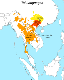
Tai people refers to the population of descendants of speakers of a common Tai language, including sub-populations that no longer speak a Tai language. There is a total of about 93 million people of Tai ancestry worldwide, with the largest ethnic groups being Dai, Thais, Isan, Tai Yai, Lao, Ahom, and Northern Thai peoples.

The Daen Lao Range is a mountain range of the Shan Hills in eastern Burma and northern Thailand. Most of the range is in Shan State, with its northern limit close to the border with China, and runs southwards across the Thai border, at the northern end of Thailand.

The Phi Pan Nam Range, also Pee Pan Nam, is a 400 km (249 mi) long system of mountain ranges in the eastern half of the Thai highlands. It is mostly in Thailand, although a small section in the northeast is within Sainyabuli and Bokeo Provinces, Laos.
Pha Daeng National Park, formerly known as Chiang Dao National Park, is a national park in Chiang Mai Province, Thailand. Established on 2 November 2000, the park covers 1,123 km2 of the Pha Daeng mountain areas of the Daen Lao Range near the border with Burma, just north of Chiang Dao Wildlife Sanctuary. The tallest summit is 1,794 m high Doi Puk Phakka.

Bokèo is a northern province of Laos. It is the smallest and least populous province in the country. Bokeo Province covers an area of 6,196 square kilometres (2,392 sq mi). Bokeo Province borders Luang Namtha Province to the northeast, Oudomxai Province to the east, Xaignabouli Province to the south, and Thailand to the southwest and Burma to the west and northwest. The province has five districts:. It is rich in deposits of precious and semiprecious stones. Bokeo's provincial capital is Houayxay on the Mekong River. The province is in the Golden Triangle, at the border of Myanmar and Thailand. There are 34 ethnic groups in the province. Houay Xay is the border town with Thailand and regional economic centre.

Vientiane Province is a province of Laos in the country's northwest. As of 2015 the province had a population of 419,090. Vientiane Province covers an area of 15,927 square kilometres (6,149 sq mi) composed of 11 districts. The principal towns are Vang Vieng and Muang Phôn-Hông.

Savannakhet is a province of Laos. The name derives from Savanh Nakhone the province's original name. It bears the same meaning as Nakhon Sawan, a city in Thailand.

Luang Namtha is a province of Laos in the country's north. From 1966 to 1976 it formed, together with Bokeo, the province of Houakhong. Luang Namtha Province covers an area of 9,325 square kilometres (3,600 sq mi). Its provincial capital is Luang Namtha. The province borders Yunnan, China to the north, Oudomxai Province to the east and southeast, Bokeo Province to the southwest, and Shan State, Burma to the northwest.

Sainyabuli Province is a province in northwest Laos. Sainyabuli town is the capital of the province. Sainyabuli is the only Lao province that is completely west of the Mekong River.

Oudomxay is a province of Laos, located in the northwest of the country. The province capital is Muang Xai.
Longchaeng District is a district of Xaisomboun Province, Laos.
