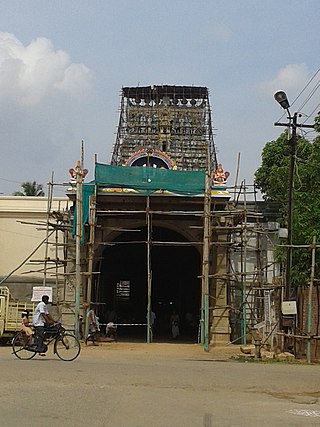
Nanguneri is a Taluk Headquarters in the District of Tirunelveli situated at a distance of 18 miles (29km) from the headquarters of the District. Vanamamalai Perumal temple located here, is a Vaishnavite Shrine also known as Arulmigu Sree Vanamamalai Totatri Perumal Temple or more commonly known as Totadri Mutt.
As of 2001[update] India census,[2] Nanguneri had a population of 6,764. Males constitute 49% of the population and females 51%. Nanguneri has an average literacy rate of 76%, higher than the national average of 59.5%: male literacy is 83%, and female literacy is 70%. In Nanguneri, 10% of the population is under 6 years of age.
Community and culture
This section is empty. You can help by adding to it. (June 2020)
Vanamamalai Perumal temple located here, is a Vaishnavite Shrine also known as Arulmigu Sree Vanamamalai Totatri Perumal Temple or more commonly known as Totadri Mutt. This temple is administered by the Vanamamalai jeeyar Mutt. The annual festivals are held in the months of Pankuni and Chittirai.
Nanguneri SEZ
Joint Venture agreement between TIDCO and AMR and its Associates signed on 10 April 2008 in the presence of the Hon'ble Chief Minister of Tamil Nadu.
Approval given by Government of India in July 2008.
SEZ Notified by Ministry of Commerce & Industry, vide Notification Ref. S.O.2690 (E) dated 18.11.2008.
Dr Karunanidhi said the Special Economic Zone (SEZ) at Nanguneri in Tirunelveli district would produce television sets for the first stage of distribution of colour television sets, which forms a major election promise of the DMK, would begin in September this year. http://news.webindia123.com/news/Articles/India/20060605/354742.html
The government of Tamil Nadu has announced that setting up of a pharma park at the Special Economic Zone at Nanguneri in Tirunelveli responding to the long-standing demand of the pharma industry in the state. A 250-acre (1km2) pharma park will be set up within the Nanguneri Special Economic Zone in Tirunelveli, Health Minister K.K.S.S.R. Ramachandran announced in the Assembly on Thursday.
Between 40 and 50 large and small pharmaceutical manufacturers and eight to 10 allied institutions would set up shop in the Nanguneri SEZ, providing 2,800 direct jobs and 6,000 indirect jobs. It was estimated that drugs worth over ₹500 crore would be manufactured. http://www.hindu.com/2006/08/18/stories/2006081811960100.htm
The minimum area of land required for establishing an SEZ – 10km2 – has been achieved.
This has revived hopes of people here that work on the ₹14,000-crore project may take off soon.
Disclosing this to reporters here on Wednesday, the collector, G. Prakash, said that representatives of Advanced Technology Manufacturing and Assembly City (ATMAC), formed by the California-based INFAC Management Corporation for executing the project, would meet him next week. As per the state government's plan, the SEZ should have light manufacturing, design and assembly facilities, modern infrastructure facilities and amenities to attract workforce from across the globe. The industries to be established would include electronic and telecommunication components, electronic and consumer durables, light and precision engineering, information technology, biotechnology, pharmaceuticals etc.
Jurong International, Singapore, has submitted its conceptual master plan, according to which the industrial sector would include ready built factories, custom built factories, units of multi-national corporations, science, business and hi-tech or information technology parks.
In the utility sector, there would be water and sewage treatment plants, power plants, telecommunication centres etc., along with roads of international standards. The state government has planned to earmark ₹700 crore for creating infrastructure facilities.
Nanguneri is situated between Tirunelveli and Nagercoil on NH-44 (old NH-7). Also, state highways like SH-89 (Nanguneri to Uvari via - Parappadi, Mannarpuram Junction, Thisayanvilai) and SH-92 (Nanguneri to Vijayapathi via - Eruvadi, Valliyur, Radhapuram) originate from this town.[4] Other than these highways, there are other 2 roads which connect Nanguneri with Kalakkad and Moolakaraipatti.
There is a bus stand in Nanguneri. Due to its location near National Highways-44, frequent buses are available to Nagercoil and Tirunelveli from here. Also, buses to Kalakkad, Thisayanvilai, Valliyur, Radhapuram, Ervadi, etc...
Nanguneri Railway Station
There is also a railway station in Nanguneri, which is situated in Tirunelveli - Nagercoil railway line. The station has 2 platforms. Trains like Guruvayur Express, Ananthapuri Express, Nagercoil - Mumbai CSMT Express, Madurai - Punalur Express, Kanyakumari - Rameshwaram Express, and other passenger trains halt in this station.
Tirunelveli, also known as Nellai and historically as Tinnevelly, is a major city in the Indian state of Tamil Nadu. It is the administrative headquarters of the Tirunelveli District. It is the fourth-largest municipal corporation in the state after Chennai, Coimbatore, and Madurai. Tirunelveli is located 624 km (388 mi) southwest of the state capital Chennai, 58 km (36 mi) away from Thoothukudi, and 73 km (45 mi) from Kanyakumari. The downtown is located on the west bank of the Thamirabarani River; its twin Palayamkottai is on the east bank. Palayamkottai is called the Oxford of South India as it has many schools and colleges. It has several important government offices.
Temple cars or Temple chariots are used to carry representations of Hindu gods around the streets of the temple on festival days. These chariots are generally manually pulled by the devotees of the deity.
Kanyakumari district is one of the 38 districts of Tamil Nadu state and the southernmost district in mainland India. It stands second in terms of population density among the districts of Tamil Nadu. It is also the richest district in Tamil Nadu in terms of per capita income, and also tops the state in Human Development Index (HDI), literacy, and education. The district's headquarters is Nagercoil.
Tirunelveli district is one of the 38 districts of Tamil Nadu state in India. It is the largest district in terms of area with Tirunelveli as its headquarters. The district was formed on 1 September 1790 by the British East India Company, and comprised the present Tirunelveli and Thoothukudi, Tenkasi and parts of Virudhunagar and Ramanathapuram district. As of 2011, the undivided district had a population of 3,077,233.
Sankarankovil is a Town in the Tenkasi district in the Indian state of Tamil Nadu. It was formerly known as Sankaranayinarkoil. Sankarankovil is the home to the Sankara Narayanar Temple.
Cheranmahadevi is a panchayat town in Tirunelveli district in the Indian state of Tamil Nadu.
Kalakad is a Municipality in Tirunelveli district in the Indian state of Tamil Nadu. Kalakad is one of the 3 Municipalities of Tirunelveli District, and is one of the fastest-growing towns in the district.
Kayathar / Kayatharu is a panchayat town in Thoothukudi district in the Indian state of Tamil Nadu.
Moolakaraipatti is a Panchayat town in Tirunelveli district in the Indian state of Tamil Nadu.
Sathankulam is a panchayat town in Thoothukudi district in the Indian state of Tamil Nadu.
Thiruvaikuntam (திருவைகுண்டம்), also referred to as Srivaikuntam is a panchayat town in Thoothukudi district in the Indian state of Tamil Nadu. It is located on the banks of the river Thamirabarani.
Thenthiruperai is a panchayat town in Thoothukudi district in the Indian state of Tamil Nadu. It is one of the nine temple shrines that constitutes Nava Tirupathi temples. It is also hosts one of the Navakailasams, Then Thiruperai Sri Kailasanathar Temple, the seventh in the series.
Avaraikulam is a village in the Tirunelveli district of Tamil Nadu, India. It is located 72 km from Tirunelveli and 20 km from Kanyakumari. Most residents are involved in agrarian activities. The Arulmigu Mutharamman Thirukovil Temple in the village is famous for its Vaigasi Thiruvizha. Avaraikulam is also referred to as 'Asaiyaa Pattinam', meaning 'Immovable Town'.
Vadakku valliyur or Valliyur is a Special Grade Town Panchayat in Radhapuram taluk in Tirunelveli district in the Indian state of Tamil Nadu.Valliyur is one of the fastest-growing towns in Tirunelveli district. This town is located along NH 7. It gets its name from the goddess Valli, consort of Lord Murugan. The place connects the big city of Tirunelveli to the city of Nagercoil and town of Kanyakumari on NH 7.
Tirunelveli Tamil also known as Nellai Tamil or ThenPaandi Tamil is one of the dialects of Tamil which is spoken in the districts of Tirunelveli, Tenkasi, Thoothukudi and Kanyakumari,some parts of Virudhunagar as well as over the vast area of south Tamil Nadu which was once ruled by the Pandiya Kings. Nellai Tamil is also known as Thenpaandi Tamil. Thenpaandi Seemai refers to the part of a Pandya kingdom which includes the present day Kanyakumari,Tirunelveli, Tenkasi and Tuticorin, some parts of Virudunagar Districts.It differs substantially from Madurai Tamil
Perumal Nagar is a village situated 5 km in east of Nanguneri, in Tirunelveli district in the Indian state of Tamil Nadu.
The Vanamamalai Perumal Temple, also known as Arulmigu Sree Vanamamalai Totatri Perumal Temple is a Hindu temple dedicated to the god Vishnu, in Vanamamalai or Totadrikshetram (Nanguneri), Tamil Nadu, India on the banks of Thamiraparani river. Constructed in the Dravidian style of architecture, the temple is glorified in the Nalayira Divya Prabandham, the early medieval Tamil canon of the Alvar saints from the 6th–9th centuries CE. It is one of the 108 Divya Desams shrines dedicated to Vishnu. Vishnu is worshipped here as Vanamalai Perumal and his consort Lakshmi as Varamanagi. The temple is believed to have been built by the Pandyas, with later contributions from Vijayanagara kings and Madurai Nayaks. The temple covers an area of 5 acres (20,000 m2) and has a five-tiered temple tower.
Thattankulam is one of the villages in Tirunelveli district in the Indian state of Tamil Nadu.
Nallankulam is a small village in Nanguneri block in Tirunelveli district of Tamil Nadu State, India. It comes under Dhalapathi Samuthram Panchayath.
This page is based on this Wikipedia article Text is available under the CC BY-SA 4.0 license; additional terms may apply. Images, videos and audio are available under their respective licenses.