
Fortín de las Flores is a city in the Mexican state of Veracruz. Fortín de las Flores is the municipal seat of Fortín municipality, which borders the municipalities of Córdoba, Naranjal and Ixtaczoquitlán. It stands on Federal Highways 190 and 180 and the Mexico City to Veracruz railway.

Córdoba, known officially as Heroica Córdoba, is a city and the seat of the municipality of the same name in the Mexican state of Veracruz. It was founded in 1618.

The Guayas River also called Rio Guayas is a major river in western Ecuador. It gives name to Guayas Province and is the most important river in South America that does not flow into the Atlantic Ocean or any of its marginal seas. Its total length, including the Daule River, is 389 km (241 mi). The Guayas River's drainage basin is 34,500 km2 and it has an average discharge of 70,000 cu ft/s. It is the national river of Ecuador and is present on the Coat of Arms.

San Martín de Porres (SMP) is a district in Lima, Peru, located in the north area of the city. It is bordered by the Chillón River, marks its natural border with Ventanilla and Puente Piedra on the north; Callao on the west; Los Olivos, Comas on the northeast; Rímac and Independencia districts on the east; The Rímac River marks its natural border with Lima District and Carmen de la Legua Reynoso on the south.
Naranjal is a district of the Alto Paraná Department, Paraguay.
Naranjal is a canton in the province of Guayas in western continental Ecuador. The canton was created in 1960 and named after its seat, Naranjal.

Los Olivos is a district of the Lima Province in Peru. Is a District of the Cono Norte area in the city of Lima.

Independencia is a district of the Lima Province in Peru. It is located in the north area of the city.
Puerto Viejo is a district of the Sarapiquí canton, in the Heredia province of Costa Rica.
Roldanillo is a town and municipality located in the Department of Valle del Cauca, Colombia.

The Naguanagua municipality is one of the 14 municipalities (municipios) that makes up the Venezuelan state of Carabobo and, according to the 2011 census by the National Institute of Statistics of Venezuela, the municipality has a population of 157,437. The town of Naguanagua is the shire town of the Naguanagua Municipality. It forms part of the greater Valencia Metropolitan Area in Venezuela. It is in the valley of the Cabriales River at the base of Cerro El Café and the El Trigal Mountain. Valencia and Naguanagua form a continuous urban area. The highway that runs from the centre of Valencia towards Puerto Cabello passes through this community; Bolivar Avenue in Valencia becomes University Avenue in Naguanagua on the northern side of a traffic roundabout, or redoma.

El Bosque, Chiapas is a town and municipality in the Mexican state of Chiapas in southern Mexico. It covers an area of 241 km2 (93 sq mi).
Lerdo de Tejada is a municipality in the Mexican state of Veracruz, located 207 kilometres (129 mi) southeast of the state capital Xalapa. It is named after Sebastián Lerdo de Tejada, the 27th President of Mexico.

Metropolitano is a bus rapid transit system serving the city of Lima, Peru. Its construction began in the year 2006.
Cañari and Puruhá are two poorly-attested extinct languages of the Marañón River basin in Ecuador that are difficult to classify. Puruhá is scarcely attested, and Cañari is known primarily from placenames. Loukotka (1968) suggests they may have been related instead to Mochica (Yunga) in a family called Chimuan, but Adelaar (2004:397) thinks it is more likely that they were Barbacoan languages.
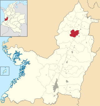
Naranjal is a municipality in the Mexican state of Veracruz, located 10 kilometres (6.2 mi) south of the city of Córdoba.
Belén de Nosarita is a district of the Nicoya canton, in the Guanacaste province of Costa Rica.

The Free Province of Guayaquil was a South American state that emerged between 1820 and 1822 with the independence of the province of Guayaquil from the Spanish monarchy. The free province had a provisional government and constitution until its annexation by Gran Colombia in 1822. Its successor was the Department of Guayaquil forming part of Gran Colombia. The Spanish province of Guayaquil was separated from the Viceroyalty of Peru and in those days it only depended legally on the court of the Real Audiencia de Quito. About a decade later, the Departments of Guayaquil, Azuay, and Ecuador separated from Gran Colombia forming the current Ecuador.
