Related Research Articles

Bastar is a district in the state of Chhattisgarh in Central India. Jagdalpur is the district headquarters. Bastar is bounded on the northwest by Narayanpur District, on the north by Kondagaon district, on the east by Nabarangpur and Koraput Districts of Odisha State, on the south and southwest by Dantewada and Sukma. The district possesses a unique blend of tribal and Odia culture.
Rajnandgaon is a city in Rajnandgaon District, in the state of Chhattisgarh, India. As of the 2011 census the population of the city was 163,122. Rajnandgaon district came into existence on 26 January 1973, as a result of the division of Durg district.
Hingoli district is an administrative district in the state of Maharashtra in India. The district is headquartered at Hingoli. The district occupies an area of 4,526 km2 and has a population of 11,77,345 of which 15.60% were urban. Hingoli was actually known as the Nizams military base as it was bordered with Vidharbha. In that era military troops, hospitals, veterinary hospital were in operation from Hingoli. Being a military base the city was one of the important and famous places of the Hyderabad state. One of the twelve Jyotirlinga shrines, the Aundha Nagnath is located in Hingoli district about 25 km south-west from district headquarter.

Durg district is a district situated in Chhattisgarh, India. The district headquarters is Durg. The district covers an area of 2,238 km². As of 2011 it is the second most populous district of Chhattisgarh, after Raipur.

Rajnandgaon is a district of the state of Chhattisgarh in central India. The administrative headquarters the district is Rajnandgaon town.

Jagdalpur is a city in Bastar district in the Indian state of Chhattisgarh. Jagdalpur hosts one of 52 shakti peeths called Danteswari Shakti Peeth and also has religiously significant shiv linga in Kotumsar Cave. Jagdalpur is the administrative headquarters of Bastar District and Bastar Division. It was earlier the capital of the former princely state of Bastar. Bastar district has multiple scenic waterfalls that is popular for tourists throughput India. It is the fourth largest city of Chhattisgarh.The city is one of the most important commercial, financial and political hub in Chhattisgarh after Raipur.

Bastar division is an administrative division of Chhattisgarh state in central India. It includes the districts of Bastar, Dantewada, Bijapur, Narayanpur, Sukma, Kondagaon and Kanker.
Narayanpur is a community development block that forms an administrative division in the Jamtara Sadar subdivision in the Jamtara district, Jharkhand state, India. It is located 24 km from Jamtara, the district headquarters.
NMDC Limited, formerly National Mineral Development Corporation, is an Indian public sector undertaking involved in the exploration of iron ore, copper, rock phosphate, limestone, dolomite, gypsum, bentonite, magnesite, diamond, tin, tungsten, graphite, coal etc. It is India's largest iron ore producer and exporter, producing more than 35 million tonnes of iron ore from three mechanized mines in Chhattisgarh and Karnataka. It also operates the only mechanized diamond mine in the country at Panna in Madhya Pradesh.
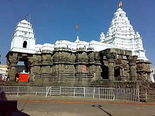
Kabirdham district is one of the 33 administrative districts of Chhattisgarh state in central India. The district was earlier known as Kawardha district. The district is located between 21.32' to 22.28' north latitude and 80.48' to 81.48' east longitude. The district covers an area of 4,447.5 km2 (1,717.2 sq mi). The city of Kawardha is its administrative headquarters. This district is known for the Bhoramdeo temple located at a distance of 18 km from the district headquarters, Kawardha.
National Highway 6 & Economic Corridor 1 (EC1), was a National Highway in India that has been separately designated under the new national highway numbering system. It was officially listed as running over 1,949 km (1,211 mi)from Surat to Kolkata. The route was also known as Asian Highway 46 (AH46) & Mumbai - Kolkata Highway and Great Eastern Highway.

Bijapur District, formerly known as Birjapur, is one of the 27 districts of the state of Chhattisgarh in central India. It is one of the two new districts created on May 11, 2007. As of 2011 it is the second least populous district of Chhattisgarh, after Narayanpur. It is the second-least literate district in India, with a literacy rate of at 41.58%, according to the 2011 census.

Narayanpur district is one of the 33 districts of Chhattisgarh State in Central India. It is one of the two districts created on May 11, 2007. It was carved out from the erstwhile Bastar district. This district occupies an area of 6640 km2 and it had a population of 110,800 in 2001. Narayanpur town is the administrative headquarters of this district. This district comprises 366 villages. It is currently a part of the Red Corridor.

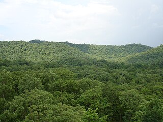
The Thirathgarh Falls is all season tourism's site and a good photography place waterfall near Jagdalpur at Kanger Ghati in Bastar district in the Indian state of Chhattisgarh.
The proposed Dalli Rajhara–Jagdalpur rail line, on paper for almost three decades, once completed, would connect Dalli Rajhara to Jagdalpur, both towns being in Chhattisgarh state in India. It would also connect Raipur, the capital city of Chhattisgarh, to Jagdalpur by rail via Durg. Jagdalpur, which is about 300 km from Raipur, is currently meaningfully connected to it only by road. There is though a roundabout rail route to reach Raipur from Jagdalpur via Koraput and Rayagada in Orissa; it is much longer and takes much longer time to be of any utility. In view of this, almost all the transport, in relation to both people and goods, between Raipur and Jagdalpur, happens only by road.
The Rowghat Mines contain the largest iron ore deposits in Chhattisgarh, India, after the Bailadila Iron Ore Mine. Rowghat Mines' reserves have been assessed at 731.93 Mn tonnes. Bailadila has reserves assessed at 1.343 Bn tonnes. Iron ore deposits in Rowghat were discovered in 1899 and in 1949 Geological Survey of India investigated the area.
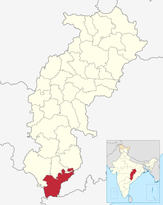
Sukma district is the southernmost district in the Indian state of Chhattisgarh. It is located in the Bastar region, known for its tribal culture. Sukma district borders with Odisha, Telangana and Andhra Pradesh.
Antagarh is a town and a Nagar Panchayat located in the Kanker district of Chhattisgarh, India. It is the administrative headquarters of its eponymous development block, tehsil, and Assembly constituency.
Chitrakot Legislative Assembly constituency is one of the 90 Legislative Assembly constituencies of Chhattisgarh state in India.
References
- ↑ Srivastava, Dayawanti, ed. (2010). India 2010, A Reference Annual (PDF). New Delhi: Publications Division, Ministry of Information and Broadcasting, Government of Indiaand. p. 1122. ISBN 978-81-230-1617-7. Archived from the original (PDF) on 29 December 2010. Retrieved 23 January 2012.
19°43′00″N81°15′00″E / 19.7167°N 81.2500°E
| | This article related to a location in the Indian state of Chhattisgarh is a stub. You can help Wikipedia by expanding it. |