Related Research Articles

Wroxeter is a village in Shropshire, England, which forms part of the civil parish of Wroxeter and Uppington, beside the River Severn, 5 miles (8.0 km) south-east of Shrewsbury.

Attingham Park is an English country house and estate in Shropshire. Located near the village of Atcham, on the B4380 Shrewsbury to Wellington road. It is owned by the National Trust. It is a Grade I listed building.

The name Rea Brook can refer to either of two brooks in Shropshire, England.

The Telford Steam Railway (TSR) is a heritage railway located at Horsehay, Telford in Shropshire, England, formed in 1976.

Upton Magna is a village and civil parish in Shropshire, England. Nearby are the villages of Uffington, Rodington and Withington, as well as the wooded Haughmond Hill. The nearest town to Upton Magna is Shrewsbury, just 2.4 miles (3.9 km) to the west.
Trench is a suburb of the new town of Telford in the borough of Telford and Wrekin and ceremonial county of Shropshire, England, on the north side of the town, north of Oakengates.

Badger is a village and civil parish in Shropshire, England, about six miles north-east of Bridgnorth. The parish had a population of 134 according to the 2001 census, falling to 126 at the 2011 census.

Codsall railway station is a railway station which serves the large village of Codsall in Staffordshire, England.

British Camp is an Iron Age hill fort located at the top of Herefordshire Beacon in the Malvern Hills. The hill fort is protected as a Scheduled Ancient Monument and is owned and maintained by Malvern Hills Conservators. The fort is thought to have been first constructed in the 2nd century BC. A Norman castle was built on the site.

Cronkhill, Atcham, Shropshire, designed by John Nash, is "the earliest Italianate villa in England".

The River Unk is a small river in Shropshire, England that runs for 9.7 miles (15.6 km) before flowing into the River Clun.

Aston Eyre Hall is an unfortified stone manor house at Aston Eyre near Bridgnorth in the English county of Shropshire, United Kingdom. It is a Grade II* listed building.

The Caersws Roman Forts are two Roman military camps at Caersws, Powys in Mid Wales. They were garrisoned during the occupation of Great Britain between the 1st and 5th centuries when this part of Wales was part of the Roman province of Britannia Superior. A surviving section of Roman road lies to the west of the encampments.

The Wombridge Canal was a tub-boat canal in Shropshire, England, built to carry coal and iron ore from mines in the area to the furnaces where the iron was extracted. It opened in 1788, and parts of it were taken over by the Shrewsbury Canal Company in 1792, who built an inclined plane at Trench. It lowered tub boats 75 feet (23 m), and remained in operation until 1921, becoming the last operational canal inclined plane in the country. The canal had been little used since 1919, and closed with the closure of the plane.

Lutley is an area of Halesowen in the West Midlands, England. Site of a mill, called the Lutley Mill, also the name of a local Pub. Lutley Mill is situated on Puddings Brook. The Lutley Gutter runs through Lutley.

Tong Castle was a very large mostly Gothic country house in Shropshire whose site is between Wolverhampton and Telford, set within a park landscaped by Capability Brown, on the site of a medieval castle of the same name.
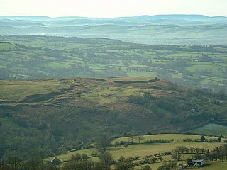
Nordy Bank is an Iron Age hill fort on Brown Clee Hill in the Shropshire Hills Area of Outstanding Natural Beauty in South Shropshire, England.
Croft Ambrey is an Iron Age hill fort in Herefordshire, England.

Aqualate Hall, a 20th-century country house, is located in Forton, Staffordshire, England, some 2 miles (3.2 km) east of the market town of Newport, Shropshire and 10 miles (16 km) west of the county town of Stafford. It is a Grade II* listed building.
Burreth is a now-deserted village in Lincolnshire.
References
- 1 2 3 Trinder, Barrie (1983). A History of Shropshire. Phillimore. p. 30. ISBN 0-85033-475-6.
- ↑ Evans, George (1991). Lost Villages of Telford. Market Drayton, Shropshire: S.B. Publications. p. 77. ISBN 1870708784.