Related Research Articles

Atlantic Beach is a village located on the west end of the Long Beach Barrier Island in the Town of Hempstead, in Nassau County, New York, United States. The population was 1,707 at the time of the 2020 census.

The Lincoln Tunnel is an approximately 1.5-mile-long (2.4 km) tunnel under the Hudson River, connecting Weehawken, New Jersey, to the west with Midtown Manhattan in New York City to the east. It carries New Jersey Route 495 on the New Jersey side and unsigned New York State Route 495 on the New York side. It was designed by Ole Singstad and named after Abraham Lincoln. The tunnel consists of three vehicular tubes of varying lengths, with two traffic lanes in each tube. The center tube contains reversible lanes, while the northern and southern tubes exclusively carry westbound and eastbound traffic, respectively.

The George Washington Bridge is a double-decked suspension bridge spanning the Hudson River, connecting Fort Lee in Bergen County, New Jersey, with the Washington Heights neighborhood of Manhattan, New York City. It is named after George Washington, a United States founding father and the country's first president. The George Washington Bridge is the world's busiest motor vehicle bridge, carrying a traffic volume of over 104 million vehicles in 2019, and is the world's only suspension bridge with 14 vehicular lanes.

The Atlantic City Expressway, officially numbered, but unsigned, as Route 446 and abbreviated A.C. Expressway, ACE, or ACX, and known locally as the Expressway, is a 44.1-mile (70.97 km) controlled-access toll road in the U.S. state of New Jersey, managed and operated by the South Jersey Transportation Authority. It serves as an extension of the freeway part of Route 42 from Turnersville southeast to Atlantic City. The Atlantic City Expressway is signed as east–west, though the mileage and exits decrease as if one is travelling north–south. It connects Philadelphia and the surrounding Philadelphia metro area with Atlantic City and other Jersey Shore resorts, and also serves other South Jersey communities, including Hammonton and Mays Landing. The expressway intersects many major roads, including Route 73 in Winslow Township, Route 54 in Hammonton, Route 50 in Hamilton Township, the Garden State Parkway in Egg Harbor Township, US 9 in Pleasantville, and the Atlantic City–Brigantine Connector near the eastern terminus in Atlantic City.

The Garden State Parkway (GSP) is a controlled-access, tolled highway that stretches the north–south length of eastern New Jersey from the state's southernmost tip near Cape May north to the New York state line at Montvale. Its name refers to New Jersey's nickname, the "Garden State". The parkway has an unsigned reference number of Route 444 by the New Jersey Department of Transportation (NJDOT). At its north end, the road becomes the Garden State Parkway Connector, a component of the New York State Thruway system that connects to the Thruway mainline in Ramapo, New York.

The Robert F. Kennedy Bridge is a complex of bridges and elevated expressway viaducts in New York City. The bridges link the boroughs of Manhattan, Queens, and the Bronx. The viaducts cross Randalls and Wards Islands, previously two islands and now joined by landfill.

The Verrazzano-Narrows Bridge is a suspension bridge connecting the New York City boroughs of Staten Island and Brooklyn. It spans the Narrows, a body of water linking the relatively enclosed New York Harbor with Lower New York Bay and the Atlantic Ocean. It is the only fixed crossing of the Narrows. The double-deck bridge carries 13 lanes of Interstate 278: seven on the upper level and six on the lower level. The span is named for Giovanni da Verrazzano, who in 1524 was the first European explorer to enter New York Harbor and the Hudson River.
The Triborough Bridge and Tunnel Authority (TBTA), doing business as MTA Bridges and Tunnels, is an affiliate agency of the Metropolitan Transportation Authority that operates seven toll bridges and two tunnels in New York City. The TBTA is the largest bridge and tunnel toll agency in the United States by traffic volume. It generated more than $2.4 billion in toll revenue from 335 million vehicles in 2023. As of 2023, its operating budget was $596 million; the budget is funded through taxes and fees.
E-ZPass is an electronic toll collection system used on toll roads, toll bridges, and toll tunnels in the Eastern United States, Midwestern United States, and Southern United States. The E-ZPass Interagency Group (IAG) consists of member agencies in several states, which use the same technology and allow travelers to use the same transponder on toll roads throughout the network.
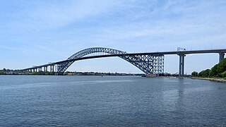
The Bayonne Bridge is an arch bridge that spans the Kill Van Kull between Staten Island, New York and Bayonne, New Jersey. It carries New York State Route 440 and New Jersey Route 440, with the two roads connecting at the state border at the river’s center. It has the sixth-longest steel arch mainspan in the world, the longest in the world at the time of its completion. The bridge is also one of four connecting New Jersey with Staten Island; the other two roadway bridges are the Goethals Bridge in Elizabeth and Outerbridge Crossing in Perth Amboy, and the rail-only span is the Arthur Kill Vertical Lift Bridge, all of which cross the Arthur Kill.

The Marine Parkway–Gil Hodges Memorial Bridge is a vertical-lift bridge in New York City, New York, that crosses Rockaway Inlet. The bridge, which opened on July 3, 1937, connects the Rockaway Peninsula in Queens, with Flatbush Avenue to Floyd Bennett Field, Belt Parkway, and the Marine Park neighborhood in Brooklyn. The bridge is designated as New York State Route 901B, an unsigned reference route.

The Cross Bay Veterans Memorial Bridge is a toll bridge that carries Cross Bay Boulevard across Jamaica Bay in Queens, New York City, between Broad Channel and the Rockaway Peninsula.

The Bronx–Whitestone Bridge is a suspension bridge in New York City, carrying six lanes of Interstate 678 over the East River. The bridge connects Throggs Neck and Ferry Point Park in the Bronx, on the East River's northern shore, with the Whitestone neighborhood of Queens on the southern shore.

AirTrain JFK is an 8.1-mile-long (13 km) elevated people mover system and airport rail link serving John F. Kennedy International Airport in New York City. The driverless system operates 24/7 and consists of three lines and nine stations within the New York City borough of Queens. It connects the airport's terminals with the New York City Subway at the Howard Beach station in the eponymous neighborhood, and with the Long Island Rail Road and the subway in the Jamaica neighborhood. Alstom operates AirTrain JFK under contract to the airport's operator, the Port Authority of New York and New Jersey.
The Newburgh–Beacon Bridge is a continuous truss toll bridge that spans the Hudson River in New York State. The bridge carries Interstate 84 (I-84) and New York State Route 52 (NY 52) between Newburgh and Beacon and consists of two separate spans. The original northern span, which now carries westbound traffic, was opened on November 2, 1963, as a two-lane bridge. A second span, completed in 1980, now carries all eastbound traffic. The span provides connections to the New York State Thruway (I-87) and U.S. Route 9W (US 9W) in Newburgh and US 9 in Fishkill. The bridges includes a 2,204-foot-long (672 m) cantilever span, with a main span of 1,000 feet (300 m) and side spans of 602 feet (183 m). The total length of all spans and approaches is 7,855 feet (2,394 m) for the north span and 7,789 feet (2,374 m) for the south span. The bridges, owned by the New York State Bridge Authority, carry six lanes of traffic and approximately 65,000 vehicles per day. The bridge is officially known as the Hamilton Fish Newburgh–Beacon Bridge.

Interstate 678 (I-678) is a north–south auxiliary Interstate Highway that extends for 14 miles (23 km) through two boroughs of New York City. The route begins at John F. Kennedy International Airport on Jamaica Bay and travels north through Queens and across the East River to the Bruckner Interchange in the Bronx, where I-678 ends and the Hutchinson River Parkway begins.

New York State Route 878 (NY 878) is an expressway on Long Island in New York state. The route exists in two sections, which both form the Nassau Expressway. NY 878's western terminus is the Belt Parkway and Conduit Avenue (NY 27) in Ozone Park, within southern Queens in New York City. Its southern terminus is at the Atlantic Beach Bridge in Lawrence, within southwestern Nassau County. NY 878 is discontinuous between Farmers Boulevard in Queens and the town of Inwood in Nassau County. The two sections are connected to each other by Rockaway Boulevard and Rockaway Turnpike.
Ocean Drive is a series of local toll roads in southern New Jersey, connecting Atlantic City to Cape May along barrier islands on the Atlantic Ocean. It consists of several roads and includes all five drawbridges owned by the Cape May County Bridge Commission.
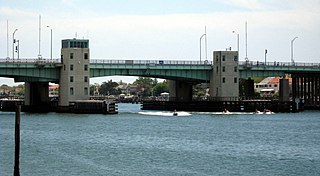
The Atlantic Beach Bridge is a 1,173-foot (358 m) long toll drawbridge across the west end of the Reynonds Channel, connecting NY 878 in Lawrence with Park Street in Atlantic Beach, in Nassau County, New York, United States.

The Bayville Bridge is a 541-foot (165 m) long drawbridge carrying Ludlam Avenue/West Shore Road, connecting the villages of Bayville and Mill Neck in Nassau County, on Long Island, New York, United States, while passing over Mill Neck Creek and Oyster Bay Harbor.
References
- 1 2 Marko, Tyler (2017-11-22). "Atlantic Beach Bridge renovation is on schedule". Herald Community Newspapers. Retrieved 2024-08-09.
- ↑ "Geospatial at the Bureau of Transportation Statistics". geodata.bts.gov. Retrieved 2024-08-09.
- ↑ "Atlantic Beach Bridge (NY 878)". www.nycroads.com. Retrieved 2024-08-09.
- 1 2 Asbury, John (2023-12-13). "E-ZPass accepted at Atlantic Beach Bridge starting Wednesday". Newsday. Retrieved 2024-08-09.
- 1 2 3 "NY Senate Resolution 2011-K1604". www.nysenate.gov. Retrieved 2024-08-09.
- ↑ Ain, Stewart (1999-07-25). "Atlantic Beach Bridge: Tolls, Jobs and Politics". The New York Times. ISSN 0362-4331 . Retrieved 2024-08-09.
- ↑ Galdamez, Hernesto (2023-04-02). "E-ZPass is 'well on its way' at Atlantic Beach Bridge". Herald Community Newspapers. Retrieved 2024-08-09.
- 1 2 Goldman, Ari L. (1977-06-19). "For Whom the Atlantic Beach Bridge Tolls?". The New York Times. ISSN 0362-4331 . Retrieved 2024-08-09.
- ↑ Bessen, Jeff (2020-06-01). "Atlantic Beach Bridge tolls are in effect, again". Herald Community Newspapers. Retrieved 2024-08-09.
- 1 2 Kihss, Peter (1952-05-11). "NEW SPAN OPENED AT ATLANTIC BEACH; 6-Lane, $7,000,000 Structure Will Be Able to Speed Cars at Rate of 7,000 an Hour By". The New York Times. ISSN 0362-4331 . Retrieved 2024-08-09.
- 1 2 3 Schwach, Ryan (2022-12-09). "Atlantic Beach Bridge Toll To Double In 2023". The Wave. Retrieved 2024-08-09.
- 1 2 Valenti, John (2022-12-07). "Atlantic Beach Bridge toll to rise to $3 on Jan. 1, a 50% increase". Newsday. Retrieved 2024-08-09.
- 1 2 "Here's your change: At a bridge without E-ZPass, cashless tolls get a try". www.nysenate.gov. 2021-02-20. Retrieved 2024-08-09.
- ↑ Bessen, Jeff (2020-03-16). "Nassau County Bridge Authority suspending toll operations at Atlantic Beach Bridge". Herald Community Newspapers. Retrieved 2024-08-09.
- ↑ Heyman, Ruth (1972-07-23). "Atlantic Beach Span a Bridge of Sighs—Exasperating Ones". The New York Times. ISSN 0362-4331 . Retrieved 2024-08-09.