Related Research Articles

Spokane International Airport is a commercial airport located approximately 7 miles (11 km) west-southwest of downtown Spokane, Washington, United States. It is the primary airport serving the Inland Northwest, which consists of 30 counties and includes areas such as Spokane, the Tri-Cities, both in Eastern Washington, and Coeur d'Alene in North Idaho. The airport's code, GEG, is derived from its former name, Geiger Field, which honored Major Harold Geiger (1884–1927).
Expo '74, officially known as the International Exposition on the Environment, Spokane 1974, was a world's fair held May 4, 1974, to November 3, 1974 in Spokane, Washington in the northwest United States. It was the first environmentally themed world's fair and attended by roughly 5.6 million people. The heart of the fair park grounds was located on Canada Island, Havermale Island, and the adjacent south bank of the Spokane River, comprising present-day Riverfront Park, in the center of the city.

Avista Stadium is a baseball park in the northwest United States, located in Spokane Valley, Washington. It is the home ballpark of the Spokane Indians, a minor league baseball team in the High-A Northwest League.

Battle Ground Lake State Park is a 275-acre (111 ha) public recreation area located three miles (4.8 km) northeast of the city of Battle Ground, Washington. The state park is covered by an evergreen forest located around a crater lake of volcanic origin. The park is managed by the Washington State Parks and Recreation Commission.

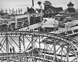
Jantzen Beach Amusement Park was a popular amusement park from 1928 to 1970 in Portland, Oregon, on Hayden Island in the middle of the Columbia River. "The Coney Island of the West" opened on May 26, 1928 as the largest amusement park in the nation, covering over 123 acres (50 ha) at the northern tip of Portland.
Downtown Spokane or Riverside is the central business district of Spokane, Washington. The Riverside neighborhood is roughly bounded by I-90 to the south, Division Street to the east, Monroe Street to the west and Boone Avenue to the north. The topography of Downtown Spokane is mostly flat except for areas downstream of the Spokane Falls which are located in a canyon; the elevation is approximately 1,900 feet (580 m) above sea level.
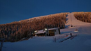
Mount Spokane Ski and Snowboard Park is a ski resort in the western United States, located inside Mount Spokane State Park in Spokane County, Washington, about 23 miles (37 km) northeast of Spokane via State Route 206. The base elevation is at 3,818 feet (1,164 m) with the peak at 5,889 feet (1,795 m), yielding a vertical drop of 2,071 feet (631 m). Its slopes are primarily east-facing, and are served by six chairlifts.

Charles I. D. Looff was a German master carver and builder of hand-carved carousels and amusement rides, who immigrated to the United States of America in 1870. Looff built the first carousel at Coney Island in 1876. During his lifetime, he built over 40 carousels, several amusements parks, numerous roller coasters and Ferris wheels, and built California's famous Santa Monica Pier. He became famous for creating the unique Coney Island style of carousel carving.
Bailey–Brayton Field is a college baseball stadium in the northwest United States, on the campus of Washington State University in Pullman, Washington. It is the home field of the Washington State Cougars of the Pac-12 Conference, and is located on the east side of the WSU campus, just southeast of Beasley Coliseum. The approximate elevation of the north-aligned diamond is 2,550 feet (775 m) above sea level and its seating capacity is 3,500.
Luna Park was an amusement park in Seattle, Washington that operated from 1907 until 1913. Designed by famed carousel carver Charles I. D. Looff, who carved and installed Coney Island's very first carousel, Luna Park took its name from Coney Island's Luna Park. On July 4, 1908, Luna Park became the site of Seattle's first manned flight.

The Riverfront Park Carrousel, also known as the Looff Carrousel and the Natatorium Park Carousel, is a carousel in Spokane, Washington built in 1909 by Charles I. D. Looff as a gift for Looff's daughter Emma Vogel and her husband Louis Vogel, who owned Natatorium Park in Spokane. It remained at Natatorium Park until 1968 when the park closed. The carousel was then relocated to its present location at Riverfront Park in 1975 where it continues to operate. It was added to the National Register of Historic Places on September 19, 1977.
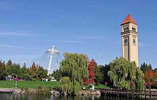
Riverfront Park, branded as Riverfront Spokane, is a public urban park in downtown Spokane, Washington that is owned and operated by the Spokane Parks & Recreation Department. The 100-acre (40 ha) park is situated along the Spokane River and encompasses the Upper Spokane Falls, which is the second largest urban waterfall in the United States.
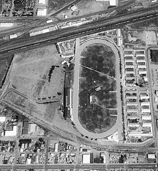
Playfair Race Course was the home of horse racing in Spokane, Washington, from 1901 to 2000. The track started out as a four-furlong (half-mile) flat oval, and expanded to five furlongs in 1946. The grandstand was on the west, with the home stretch heading south, and the stables were on the east side.
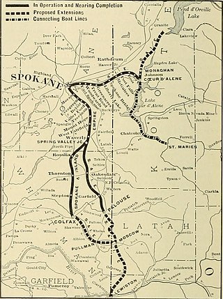
The Spokane and Inland Empire Railroad Company (S.&I.E.R.R.Co.) was an electrified interurban railway operating in Spokane, Washington and vicinity, extending into northern and central Idaho. The system originated in several predecessor roads beginning c. 1890, incorporated in 1904, and ran under its own name to 1929. It merged into the Great Northern Railway and later, the Burlington Northern Railroad, which operated some roads into the 1980s.

West Central is a neighborhood in Spokane, Washington. As the name suggests it is located centrally on the west side of the city. Downtown Spokane is immediately east of the neighborhood, and spreads into West Central along Monroe Street in the Kendall Yards area. The neighborhood is diverse, with single and multi-family residential zones dating back to the early days of Spokane, a new mixed use development on the site of a former rail yard, the Spokane County Courthouse campus and associated government buildings and a few commercial districts. The Spokane River gorge winds around the southern and western edge of the neighborhood. It is home to Nettleton's Addition Historic District, which was added to the National Register of Historic Places in March 2006, and is also the largest historic district on the Washington State Heritage Register.
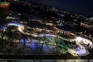
The Numerica Skate Ribbon is a multi-purpose venue and attraction located in Riverfront Park in Downtown Spokane, Washington. It primarily serves as a year-round outdoor venue for skating, supporting hard surface skating activities such as roller skating, scootering, and skateboarding in the warm months, and converting over for ice skating during the winter months. The ribbon also hosts other events and programmed activities, such as art walks, throughout the year.

The Breslin is a historic six-story building in the Cliff/Cannon neighborhood of Spokane, Washington. It was designed by architect Albert Held in the Classical Revival style, and built in 1910 by W.H. Stanley with "Tenino sandstone, press red brick and cream-colored terra cotta" at a cost of $100,000.

Casa del Rey Hotel was a resort hotel in Santa Cruz, California. During World War II the hotel was converted to the Naval Convalescent Hospital, Santa Cruz. The hotel was built in 1911 by Fred Swanton on Beach Street as a Santa Cruz Boardwalk development plan. The Resort Hotel had: a pool; gardens; and a grand pedestrian bridge to cross the street to visit the beach. The hotel was at about 500 Beach Street and Cliff Street. In addition to the hotel, there were built Cottage apartments. Later after the war the hotel became a senior citizen housing. In the 1989 Loma Prieta earthquake there was serious damage to the hotel and was taken down. The site now is the parking lot across the street from the Santa Cruz Beach Boardwalk amusement park.

Doyle's Ice Cream Parlor is a locally owned ice cream shop that has been located in Spokane's West Central neighborhood since 1939. Doyle's is open from spring to early fall, Wednesdays through Sundays.

Liberty Park is a 22 acres (8.9 ha) public park at Third Ave and Perry St in East Central, Spokane, Washington. It is open daily with entry gratis.
References
- ↑ "50 years on, remembering Spokane's Natatorium Park | The Spokesman-Review". www.spokesman.com.
- ↑ "Natatorium Park".
- ↑ "Spokane History – Natatorium Park and the Loof Carousel – 1889". discoveryrobots.org.
- ↑ Rebstock, Tracy L. "Spokane's Amusement Park: Natatorium Park". Spokane Historical.
- ↑ "Spokane's Natatorium Park – In The Beginning". natpark.org.
- ↑ Catalog of Copyright Entries. U.S. Government Printing Office. 1909.