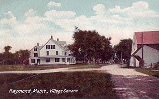
Raymond is a town in Cumberland County, Maine, United States. Raymond is included in the Lewiston-Auburn, Maine metropolitan New England city and town area. The population was 4,536 at the 2020 census. It is a summer recreation area and is part of the Portland–South Portland–Biddeford, Maine metropolitan statistical area. Raymond Neck is the landing for the ferry to the town of Frye Island in Sebago Lake. The Raymond school system is currently affiliated with the Windham school system in a district known as RSU 14.

U.S. Route 93 (US 93) is a major north–south 1,359-mile (2,187 km) U.S. Numbered Highway in the western United States, that connects U.S. Route 60 (US 60) in Wickenburg, Arizona, with British Columbia Highway 93 at the Canadian border. The highway passes through Kingman, Arizona; Las Vegas, Nevada; Twin Falls, Idaho; and Missoula, Montana.

U.S. Route 69 (US 69) is a major north–south United States highway in the central United States. When it was first created, it was only 150 miles (241 km) long, but it has since been expanded into a Minnesota to Texas cross-country route. The highway's southern terminus is in Port Arthur, Texas at an intersection with State Highway 87. Its northern terminus is in Albert Lea, Minnesota at Minnesota State Highway 13.
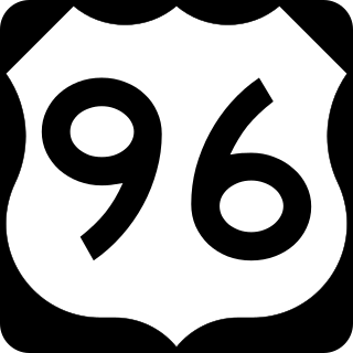
U.S. Highway 96 (US 96) is a north–south United States Numbered Highway that runs for about 117.11 miles (188.47 km) entirely in the U.S state of Texas. Its number is a violation of the standard numbering convention, as even-numbered two-digit highways are east–west routes by rule. As of 2004, the highway's southern terminus is in Port Arthur at an intersection with State Highway 87 (SH 87). Its northern terminus is in Tenaha at an intersection with US 59 /(Future I-369) and US 84.
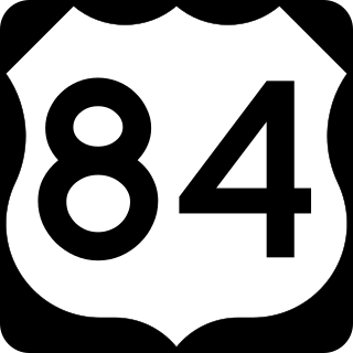
U.S. Route 84 (US 84) is an east–west United States Numbered Highway that started as a short Georgia–Alabama route in the original 1926 scheme. Later, in 1941, it had been extended all the way to Colorado. The highway's eastern terminus is a short distance east of Midway, Georgia, at an Interchange with I-95. The road continues toward the nearby Atlantic Ocean as a county road. Its western terminus is in Pagosa Springs, Colorado, at an intersection with US 160.

U.S. Route 97 (US 97) is a major north–south route of the United States Numbered Highway System in the Pacific Northwest region. It runs for approximately 670 miles (1,078 km) through the states of California, Oregon, and Washington, primarily serving interior areas on the east side of the Cascade Mountains. The highway terminates to the south at a junction with Interstate 5 (I-5) in Weed, California, and to the north at the Canadian border near Osoyoos, British Columbia, where it becomes British Columbia Highway 97. Major cities on the US 97 corridor include Klamath Falls, Bend, and Redmond in Oregon; and Yakima, Ellensburg, and Wenatchee in Washington. A portion of the highway in California and Oregon is part of the Volcanic Legacy Scenic Byway.

Lashio is the largest town in northern Shan State, Myanmar, about 200 kilometres (120 mi) north-east of Mandalay. It is situated on a low mountain spur overlooking the valley of the Yaw River. Loi Leng, the highest mountain of the Shan Hills, is located 45 km (28 mi) to the south-east of Lashio.

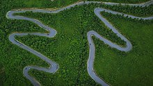
State Route 20 (SR 20), also known as the North Cascades Highway, is a state highway that traverses the U.S. state of Washington. It is the state's longest highway, traveling 436 miles (702 km) across the northern areas of Washington, from U.S. Route 101 (US 101) at Discovery Bay on the Olympic Peninsula to US 2 near the Idaho state border in Newport. The highway travels across Whidbey Island, North Cascades National Park, the Okanagan Highland, the Kettle River Range, and the Selkirk Mountains. SR 20 connects several major north–south state highways, including Interstate 5 (I-5) in Burlington, US 97 through the Okanogan–Omak area, SR 21 in Republic, and US 395 from Kettle Falls to Colville.

State Route 14 (SR 14) is a 180.66-mile-long (290.74 km) state highway in the U.S. state of Washington. The highway travels east-west on the north side of the Columbia River, opposite Interstate 84 (I-84) to the south in Oregon. SR 14 forms a section of the Lewis and Clark Trail Scenic Byway and begins at an interchange with I-5 in Vancouver. The highway travels east as a four-lane freeway through Camas and Washougal and intersects I-205. SR 14 continues east as a two-lane highway through Clark, Skamania, Klickitat, and Benton counties before it ends at an interchange with I-82 and U.S. Route 395 (US 395) near Plymouth.
Mill Creek is a 14.5-mile-long (23.3 km) tributary of Opequon Creek, belonging to the Potomac River and Chesapeake Bay watersheds, located in Berkeley County in West Virginia's Eastern Panhandle. Its name reflects its past as a popular site for various types of mills, beginning with one constructed by Morgan Morgan in the mid-18th century near his cabin in present-day Bunker Hill.

State Route 49 is a primary state highway in the U.S. state of Virginia. The state highway runs 69.01 miles (111.06 km) from the North Carolina state line in Virgilina, Virginia in Halifax County, where the highway continues south as North Carolina Highway 49, north to U.S. Route 360 near Burkeville in Nottoway County. SR 49 passes through Southside Virginia, connecting Virgilina and Burkeville with Clarksville and Chase City in Mecklenburg County, Victoria in Lunenburg County, and Crewe in Nottoway County. Via US 360, the state highway connects Richmond with the John H. Kerr Reservoir.

State Route 97 is a 10.91-mile-long (17.56 km) state highway in the U.S. state of Arizona. It runs from U.S. Route 93 northwest of Congress northeast to SR 96 southeast of Bagdad. The road was built by the late 1930s and improved during the late 1940s. Established as a state route in 1962, SR 97 was paved in the early 1970s. In 2000, the highway was officially added to the State Highway system.

Interstate 35 (I-35) is a major north–south Interstate Highway that runs from Laredo, Texas near the Mexican border to Duluth, Minnesota. In Texas, the highway begins in Laredo and runs north to the Red River north of Gainesville, where it crosses into Oklahoma. Along its route, it passes through the cities of San Antonio, Austin, and Waco before splitting into two branch routes just north of Hillsboro: I-35E heads northeast through Dallas, while I-35W turns northwest to run through Fort Worth. The two branches rejoin in Denton to again form I-35, which continues to the Oklahoma state line. The exit numbers for I-35E maintain the sequence of exit numbers from the southern segment of I-35, and the northern segment of I-35 follows on from the sequence of exit numbers from I-35E. I-35W maintains its own sequence of exit numbers.
National Highway 1 (NR1), literally "The Road to Mandalay ") is an important south–north flowing highway of central Burma and the busiest road in the country. It connects Yangon to Meiktila where it joins the National Highway 4 going east and then NR1 continues north to Mandalay.
National Highway 5 (NR5) is a highway of southern-central Burma. It connects Taungoo to Hopong, east of Taunggyi.
National Road 36 or State Highway 36 is a road of northeastern Burma.
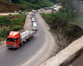
National Highway 31 is a major highway of central/northeastern Burma. It starts in Mandalay at the rim of the Mandalay Palace area from National Highway 3 at 21°58′59″N96°5′3″E and ends in Waingmaw/Myitkyina in Kachin State at 25°21′1″N97°26′8″E. The major settlements the road passes through from Mandalay are as follows: Lamaing, Madaya, Yentha, Letkhokpin, Chaunggyi, Shwenyaungbin, Kyatpyin, Mogok, Mong Nit, Pinkyein, Tonkwa, Madangyang, Bhamo, Myothit, Dawhpumyang, Kaxu before finally arriving in Waingmaw.

India–Myanmar–Thailand Trilateral Highway, 1,360 km (850 mi) long route, is a 4-lane highway under construction under India's Look East policy that will connect Moreh, India with Mae Sot, Thailand via Myanmar. Imphal-Mandalay-Bangkok 1,813 km (1,127 mi) route, consisting of Imphal-Mandalay 584 km (363 mi) and Mandalay-Bangkok 1,397 km (868 mi), is a highway in good condition except for 101 km (63 mi) part of 120 km (75 mi) long Kalewa-Yagyi stretch being built to 2-lane in each direction highway by India.