
Interstate 75 (I-75) is a major north–south Interstate Highway in the Great Lakes and Southeastern regions of the United States. As with most Interstates that end in 5, it is a major cross-country, north–south route, traveling from State Road 826 and SR 924 on the Hialeah–Miami Lakes border to Sault Ste. Marie, Michigan, at the Canadian border. It is the second-longest north–south Interstate Highway and the seventh-longest Interstate Highway overall.

U.S. Route 12 or U.S. Highway 12 (US 12) is an east–west United States Numbered Highway, running from Aberdeen, Washington, to Detroit, Michigan, for almost 2,500 miles (4,000 km). The highway has mostly been superseded by Interstate 90 (I-90) and I-94, but, unlike most U.S. Highways that have been superseded by an Interstate, US 12 remains intact as an important link for local and regional destinations. The highway's western terminus in Aberdeen is at an intersection with US 101, while the highway's eastern terminus in Downtown Detroit is at the corner of Michigan and Cass avenues, near Campus Martius Park.
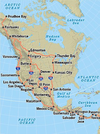
The Pan-American Highway route in North America is the portion of a network of roads nearly 48,000 kilometres (30,000 mi) in length that travels through the mainland nations of the Americas. No definitive length of the Pan American Highway exists because the Canadian government has never officially defined any specific route as being part of the Pan-American Highway, while in the United States, the Federal Highway Administration (FHWA) has designated the entire Interstate Highway System part of the Pan-American Highway System, although this has not yet been reinforced by any official highway signage. Mexico officially has many branches connecting to various interstate highways at the U.S. border.

The Crowsnest Highway is an east-west highway in British Columbia and Alberta, Canada. It stretches 1,161 km (721 mi) across the southern portions of both provinces, from Hope, British Columbia to Medicine Hat, Alberta, providing the shortest highway connection between the Lower Mainland and southeast Alberta through the Canadian Rockies. Mostly two-lane, the highway was officially designated in 1932, mainly following a mid-19th-century gold rush trail originally traced out by an engineer named Edgar Dewdney. It takes its name from the Crowsnest Pass, the location at which the highway crosses the Continental Divide between British Columbia and Alberta.

U.S. Route 45 is a major north-south United States highway and a border-to-border route, from Lake Superior to the Gulf of Mexico. A sign at the highway's northern terminus notes the total distance as 1,297 miles (2,087 km).

U.S. Route 287 (US 287) is a north–south United States highway. At 1,791 miles (2,882 km) long, it is the second longest three-digit U.S. Route, behind US 281. It serves as the major truck route between Fort Worth and Amarillo, Texas, and between Fort Collins, Colorado, and Laramie, Wyoming. The highway is broken into two segments by Yellowstone National Park, where unnumbered park roads serve as a connector.

Shan State is a state of Myanmar. Shan State borders China (Yunnan) to the north, Laos to the east, and Thailand to the south, and five administrative divisions of Burma (Myanmar) in the west. The largest of the 14 administrative divisions by land area, Shan State covers 155,800 km2, almost a quarter of the total area of Myanmar. The state gets its name from Burmese name for the Tai peoples: "Shan people". The Tai (Shan) constitute the majority among several ethnic groups that inhabit the area. Shanland is largely rural, with only three cities of significant size: Lashio, Kengtung, and the capital, Taunggyi. Taunggyi is 150.7 km northeast of the nation's capital Naypyitaw.
Route 2 is a major provincial highway in the Canadian province of New Brunswick, carrying the main route of the Trans-Canada Highway in the province. The highway connects with Autoroute 85 at the border with Quebec and Highway 104 at the border with Nova Scotia, as well as with traffic from Interstate 95 in the U.S. state of Maine via the short Route 95 connector. A core route in the National Highway System, Route 2 is a four-lane freeway in its entirety, and directly serves the cities of Edmundston, Fredericton, and Moncton.

State Highway 5 is the name assigned to two distinct state highways in the U.S state of Oklahoma. One runs for 20.42 miles (32.86 km) through extreme southwestern Oklahoma, passing through Harmon and Jackson Counties. The other is 98.2 miles (158.0 km) long and runs through southwest Oklahoma, connecting US-283 south of Altus to US-70 at Waurika.
Mong Ton also known historically as Möngtung and Maington, is a town and seat of Mong Ton Township in Mong Hsat District, Shan State in eastern Myanmar near the border with Thailand. Mong is equivalent to [Township or land]."Ton"is equivalent to [Royal City]. It is located in the Daen Lao Range, in the eastern part of the Shan State, east of the Salween River. Mong Ton lies on the National Highway 22 and connected to NarkgMuu and Ponparkyin, is also connected to Mong Hsat by National Highway 49 which begins to the north-east of the town.
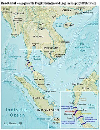
The Thai Canal, also known as Kra Canal or Kra Isthmus Canal, is any of several proposals for a canal that would connect the Gulf of Thailand with the Andaman Sea across the Kra Isthmus in southern Thailand. Such a canal would significantly reduce travel times through heavily-navigated trade routes.

Asian Highway 3 (AH3) is a route of the Asian Highway Network which runs 7,331 km (4,555 mi) from Ulan-Ude, Russia to Tanggu, China; and Shanghai, China to Chiang Rai, Thailand and Kengtung, Myanmar.
The United States Border Patrol operates 71 traffic checkpoints, including 33 permanent traffic checkpoints, near the Mexico–United States border. The stated primary purpose of these inspection stations is to deter illegal immigration and smuggling activities. After the September 11 attacks in 2001, they took on the additional role of terrorism deterrence. These checkpoints are located between 25 and 75 miles of the Mexico–United States border along major U.S. highways; near the southern border of the contiguous United States. Their situation at interior locations allow them to deter illegal activities that may have bypassed official border crossings along the frontier. The checkpoints are divided among nine Border Patrol sectors. There are a number of these checkpoints near the northern border of the contiguous U.S. as well, within 100 miles (160 km) of the Canada–U.S. border.

National Highway 4 is an important west–east flowing highway of central Burma. It connects the town of Meiktila in the Mandalay Region to Tachileik in Shan State in the east on the border with Thailand. The highway begins near Meiktila at 20°52′22″N95°52′59″E where it is linked by the National Highway 1 coming from the south and at Hopong it meets the National Highway 5 which goes south at 20°48′2″N97°10′25″E.
National Highway 5 (NR5) is a highway of southern-central Burma. It connects Taungoo to Hopong, east of Taunggyi.
Wan Hsa-la is a village in Mong Ton Township in Mong Hsat District, Shan State. It lies near the Salween River and is surrounded by forests, connected by road across the hills to Mong Ton and Thailand in the east. The village was the site of a battle in 1948 between the Burmese army together with the Chinese Communist troops dressed in Burmese army uniforms against the KMT, commanded by General Li. The village is connected by National Highway Rd 22 (Myanmar) to Mong Ton in the east and after a bridge across the Salween south of the village the road eventually joins National Highway 22(Myanmar) at Nansang.
Namaklwe is a village near the Burma-Thai border in Mong Ton Township of Shan State in eastern Myanmar, across the border from Nong Uk, Thailand. It lies along National Highway 22 which connects it to Ponparkyin in the north, and Chiang Mai may be accessed to the south. It has been a site of conflict when the Burma Frontier Force once gunned down Siamese invaders at Namaklwe.
Mok, also known as Amok, Hsen-Hsum, and Muak, is an Angkuic language or dialect cluster spoken in Shan State, Myanmar

The Kaladan Road Project is a US$484 million project connecting the eastern Indian seaport of Kolkata with Sittwe seaport in Rakhine State, Myanmar by sea. In Myanmar, it will then link Sittwe seaport to Paletwa in Chin State via the Kaladan river boat route, and then from Paletwa by road to Mizoram state in Northeast India. All components of the project, including Sittwe port and power, river dredging, Paletwa jetty, have been completed, except the under construction Zorinpui-Paletwa road. Originally, the project was scheduled to be completed by 2014, but end-to-end project is expected to be fully operational only by December 2023 as per November 2023 update.

Mongpu or Möngpu was a small state of the Shan States in what is today Burma.