
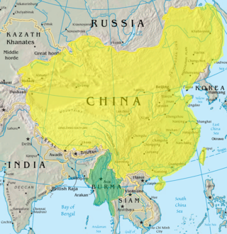
Myanmar, officially the Republic of the Union of Myanmar, also known as Burma, is a country in Southeast Asia. It is the largest country by area in Mainland Southeast Asia and has a population of about 55 million. It is bordered by Bangladesh and India to its northwest, China to its northeast, Laos and Thailand to its east and southeast, and the Andaman Sea and the Bay of Bengal to its south and southwest. The country's capital city is Naypyidaw, and its largest city is Yangon.

The Shan people, also known as the Tai Long or Tai Yai, are a Tai ethnic group of Southeast Asia. The Shan are the biggest minority of Burma (Myanmar) and primarily live in the Shan State of this country, but also inhabit parts of Mandalay Region, Kachin State, Kayah State, Sagaing Region and Kayin State, and in adjacent regions of China, Laos, Assam and Meghalaya, Cambodia, Vietnam and Thailand. Though no reliable census has been taken in Burma since 1935, the Shan are estimated to number 4–6 million, with CIA Factbook giving an estimate of five million spread throughout Myanmar which is about 10% of the overall Burmese population.
Tak is one of Thailand's seventy-seven provinces (changwat) and lies in lower northern Thailand. Neighbouring provinces are Mae Hong Son, Chiang Mai, Lamphun, Lampang, Sukhothai, Kamphaeng Phet, Nakhon Sawan, Uthai Thani and Kanchanaburi. The western edge of the province has a long boundary with Kayin State of Myanmar (Burma).

Shan State is a state of Myanmar. Shan State borders China (Yunnan) to the north, Laos to the east, and Thailand to the south, and five administrative divisions of Burma (Myanmar) in the west. The largest of the 14 administrative divisions by land area, Shan State covers 155,800 km2, almost a quarter of the total area of Myanmar. The state gets its name from Burmese name for the Tai peoples: "Shan people". The Tai (Shan) constitute the majority among several ethnic groups that inhabit the area. Shanland is largely rural, with only three cities of significant size: Lashio, Kengtung, and the capital, Taunggyi. Taunggyi is 150.7 km northeast of the nation's capital Naypyitaw.

The Karen, also known as the Kayin, Kariang or Kawthoolese, are an ethnolinguistic group of Sino-Tibetan language-speaking peoples. The group as a whole is heterogeneous and disparate as many Karen ethnic groups do not associate or identify with each other culturally or linguistically. These Karen groups reside primarily in Kayin State, southern and southeastern Myanmar. The Karen account for around seven percent of the Burmese population. Many Karen have migrated to Thailand, having settled mostly on the Myanmar–Thailand border. A few Karen have settled in the Andaman and Nicobar Islands, India, and other Southeast Asian and East Asian countries.

Three Pagodas Pass is a pass in the Tenasserim Hills on the border between Thailand and Myanmar (Burma), at an elevation of 282 metres (925 ft). The pass links the town of Sangkhla Buri in the north of Kanchanaburi Province, Thailand, to the town of Payathonsu in the south of Kayin State, Myanmar.

The Karenni States, also known as Red Karen States, was the name formerly given to the states inhabited mainly by the Red Karen, in the area of present-day Kayah State, eastern Burma. They were located south of the Federated Shan States and east of British Burma.

Myeik is a rural city in Tanintharyi Region in Myanmar (Burma), located in the extreme south of the country on the coast off an island on the Andaman Sea. As of 2010, the estimated population was over 209,000. Myeik is the largest city in Tanintharyi Region, and serves as the regional headquarters of Myanmar Navy's Tanintharyi Regional Command. The area inland from the city is a major smuggling corridor into Thailand. The Singkhon Pass, also known as the Maw-daung Pass, has an international cross-border checkpoint.

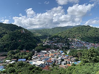
Kawthaung is a border town located in the southernmost part of Myanmar, in the Tanintharyi Region. During British rule in Burma between 1824 and 1948, it was known as Victoria Point. As of 2021, it has a population of 57,949. Facing Ranong in Thailand, Kawthaung is one of 7 official border trade posts with Thailand.
Mong Ton also known historically as Möngtung and Maington, is a town and seat of Mong Ton Township in Mong Hsat District, Shan State in eastern Myanmar near the border with Thailand. Mong is equivalent to [Township or land]."Ton"is equivalent to [Royal City]. It is located in the Daen Lao Range, in the eastern part of the Shan State, east of the Salween River. Mong Ton lies on the National Highway 22 and connected to NarkgMuu and Ponparkyin, is also connected to Mong Hsat by National Highway 49 which begins to the north-east of the town.
Battle of Yunnan-Burma Road was the name of the Chinese intervention to aid their British allies in the 1942 Burma Campaign. Its forces were composed of the Fifth, Sixth and Sixty-sixth Army under the command of the Chinese Expeditionary Force in Burma, commanded by Lt. General Joseph Stilwell, Lt. General Luo Zhuoying was his executive officer.
The Ministry of Development of North Eastern Region is a Government of India ministry, established in September 2001, which functions as the nodal Department of the Central Government to deal with matters related to the socio-economic development of the eight States of Northeast India: Arunachal Pradesh, Assam, Manipur, Meghalaya, Mizoram, Nagaland, Tripura and Sikkim. It acts as a facilitator between the Central Ministries/ Departments and the State Governments of the North Eastern Region in the economic development including removal of infrastructural bottlenecks, provision of basic minimum services, creating an environment for private investment and to remove impediments to lasting peace and security in the North Eastern Region.

Payathonzu (Pwo Eastern Karen: ကၠံင်သိုင့်ဖၠုံးဍုံ; Burmese: ဘုရားသုံးဆူမြို့ is a town in the Karen State of south Myanmar, close to the border with Thailand. It is separated from the Thai border township of Nong Lu by the Three Pagodas Pass. It is also the administrative seat of Hpayarthonezu Sub-township in Kyain Seikgyi Township, Kawkareik District of Kayin State in Myanmar.

Tanintharyi Region is an administrative region of Myanmar, covering the long narrow southern part of the country on the upper Malay peninsula, reaching to the Kra Isthmus. It borders the Andaman Sea to the west and the Tenasserim Hills, beyond which lie Thailand, to the east. To the north is the Mon State. There are many islands off the coast, the large Mergui Archipelago in the southern and central coastal areas and the smaller Moscos Islands off the northern shores. The capital of the division is Dawei (Tavoy). Other important cities include Myeik (Mergui) and Kawthaung. The division covers an area of 43,344.9 square kilometres (16,735.6 sq mi), and had a population of 1,406,434 at the 2014 Census.

Mong Pan Township is a township of Langkho District in the Shan State of Myanmar. The capital town is Mong Pan or Möngpan, formerly the residence of the Sawbwa.
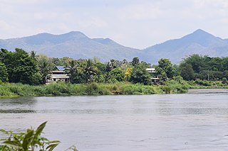
Tachileik is a border town in Shan State of eastern Myanmar. It is the administrative seat of Tachileik Township and Tachileik District and most populated city in eastern Shan State with 51,553 residents per 2014 census count, ahead of Kyaing Tong, but only 4th statewide. It faces Mae Sai in Thailand, and is home to one of Myanmar's seven official border trade posts with Thailand.
The Sino-Burmese War, also known as the Qing invasions of Burma or the Myanmar campaign of the Qing dynasty, was a war fought between the Qing dynasty of China and the Konbaung dynasty of Burma (Myanmar). China under the Qianlong Emperor launched four invasions of Burma between 1765 and 1769, which were considered one of his Ten Great Campaigns. Nonetheless, the war, which claimed the lives of over 70,000 Chinese soldiers and four commanders, is sometimes described as "the most disastrous frontier war that the Qing dynasty had ever waged", and one that "assured Burmese independence". Burma's successful defense laid the foundation for the present-day boundary between the two countries.
Myanmar–Thailand relations refers to the current and historical relations between Myanmar and Thailand. Myanmar has an embassy in Bangkok. Thailand has an embassy in Yangon. Relations between Burma and Thailand focus mainly on economic issues and trade. There is sporadic conflict with Thailand over three disputed islands.

The China–Myanmar border is the international border between the territory of the People's Republic of China and Myanmar. The border is 2,129 km (1,323 mi) in length and runs from the tripoint with India in the north to the tripoint with Laos in the south.

The Myanmar–Thailand border is the international border between the territory of Myanmar and Thailand. The border is 2,416 km (1,501 mi) in length and runs from the tripoint with Laos in the north to Andaman Sea coast in the south.
