
Kanchanaburi is the largest of the western provinces (changwat) of Thailand. The neighboring provinces are Tak, Uthai Thani, Suphan Buri, Nakhon Pathom, and Ratchaburi. In the west it borders Kayin State, Mon State, and the Tanintharyi Region of Myanmar.

Dawei is a city in south-eastern Myanmar and is the capital of the Tanintharyi Region, formerly known as the Tenasserim Division, on the eastern bank of the Dawei River. The city is about 614.3 km (381.7 mi) southeast of Yangon. Its population is 146,964. Dawei is a port at the head of the Dawei River estuary, 30 km (18.6 mi). from the Andaman Sea. As a result, the city is prone to flooding during the monsoon season. Dawei People is also the name of one of Myanmar's 135 ethnic minorities.
Tanintharyi or Taninthayi is a small town in Tanintharyi Township, Myeik District, in the Tanintharyi Region of south-western Myanmar. It is the administrative seat for the township. The town is located on the Great Tenasserim River which eventually enters the sea at Myeik. The town is located at the confluence of this river and a tributary known as the "Little Tenasserim River" which runs south.

Tanintharyi Region is a region of Myanmar, covering the long narrow southern part of the country on the northern Malay Peninsula, reaching to the Kra Isthmus. It borders the Andaman Sea to the west and the Tenasserim Hills, beyond which lie Thailand, to the east. To the north is the Mon State. There are many islands off the coast, the large Mergui Archipelago in the southern and central coastal areas and the smaller Moscos Islands off the northern shores. The capital of the division is Dawei (Tavoy). Other important cities include Myeik (Mergui) and Kawthaung. The division covers an area of 43,344.9 square kilometres (16,735.6 sq mi), and had a population of 1,406,434 at the 2014 Census.
Rail transport in Myanmar began in 1877. Three private rail companies were nationalised nineteen years later. During the Japanese occupation of Burma, Allied prisoners of war were forced to build the Burma Railway. Myanmar Railways has expanded its network somewhat since 1988.
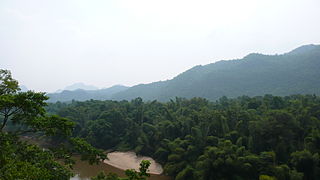
The Tenasserim Hills or Tenasserim Range is the geographical name of a roughly 1,700 km long mountain chain, part of the Indo-Malayan mountain system in Southeast Asia.
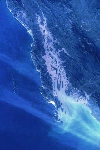
The Dawei River or Tavoy River is a river of the Tanintharyi Region, Burma.
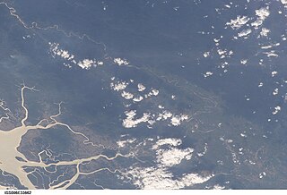
The Great Tenasserim River or the Tanintharyi River is a major river of southeastern Burma. It flows through the Tanintharyi Region, past the town of Tanintharyi, and enters the sea at Myeik (Mergui). The river rises from the Tenasserim Range at an altitude of 2,074 m (6,804 ft), and flows into the Andaman Sea. The region formed by this river is also known as Tenasserim, or Tanintharyi in Burmese. It is in a constricted coastal region in southeastern Myanmar, which borders Thailand on the east and the Andaman Sea on the west.

The Burmese–Siamese War (1759–1760) or Alaungpaya's War was the military conflict between the Konbaung dynasty of Burma (Myanmar) and the Ban Phlu Luang Dynasty of the Ayutthaya Kingdom of Siam, in which the Burmese forces under King Alaungpaya of the Konbaung dynasty invaded Siam. After about a century of relative hiatus of Burmese–Siamese conflicts, this war reignited the new round of military conflicts between Burma and Siam that would last for about a century to come.
The Tavoyan or Dawei dialect of Burmese (ထားဝယ်စကား) is spoken in Dawei (Tavoy), in the coastal Tanintharyi Region of southern Myanmar (Burma).

Tanintharyi Line is a 1,000 mm gauge railway line in Myanmar's southernmost region, Tanintharyi Region, operated by Myanma Railways. The line runs from Mawlamyine Railway Station (Moulmein) to the Dawei area, with connections to Yangon Central Railway Station, it is under construction extending towards Myeik from the current terminus of Thayetchaung Station, which lies just after Dawei Station. Current section in operation includes the part from Mawlamyaing Station to Thayetchaung. It is expected to become a part of a pan-Asian railway network, allowing spur connections specifically to Thailand. A spur connection between the SRT rail head at Nam Tok railway station in Kanchanaburi Province to Dawei Station through mountains is planned by Thai interests backed by Japanese funding, though other rail connections are certainly possible.

Singkhon Pass, also referred to as Sing Khon and as Maw Daung after the name of the Burmese town west of the border, is a pass across the Tenasserim Hills on the border between Thailand and Myanmar, at an elevation of 245 metres (804 ft). The pass is close to the narrowest point of Thailand in Khlong Wan (คลองวาฬ) subdistrict, Mueang Prachuap Khiri Khan District, Prachuap Khiri Khan Province.
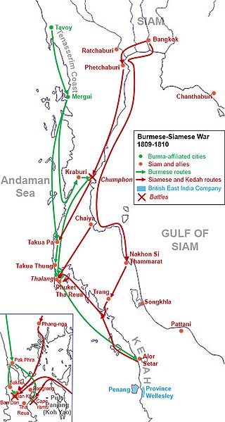
The Burmese–Siamese War (1809–1812) or the Burmese Invasion of Thalang was an armed conflict fought between Burma under Konbaung dynasty and Siam under the Chakri dynasty, during the period of June 1809 and January 1812. The war centered on the control of the Phuket Island, also known as Thalang or Junk Ceylon, and the tin rich Andaman Coast. The war also involved the Kedah Sultanate. This occasion was the last Burmese offensive expedition into Siamese territories in Thai history, with British acquisition of the Tenasserim Coast in 1826, following the First Anglo-Burmese War, removing several hundred miles of the existing land border between Siam and Burma. The war also left Phuket devastated and depopulated for many decades until its reemergence as a tin mining center in the late 19th century.
Phu Nam Ron is a pass across the Tenasserim Hills on the border between Thailand and Myanmar, at an elevation of 350 metres (1,150 ft). The border checkpoint on the Thai side is in Ban Kao Subdistrict, Mueang Kanchanaburi District, Kanchanaburi Province.
Myitta Subtownship is a subtownship of Dawei Township, Dawei District in the Taninthayi Division of Myanmar. The main town is Myitta (Matamyu), located on the western side of the Tenasserim Range near the confluence of two tributaries of the Great Tenasserim River.
Kyaukton, is a village of Dawei District in the Taninthayi Division of Myanmar. It is located on the western side of the Tenasserim Range, 24 km to the northwest of Sinbyudaing.
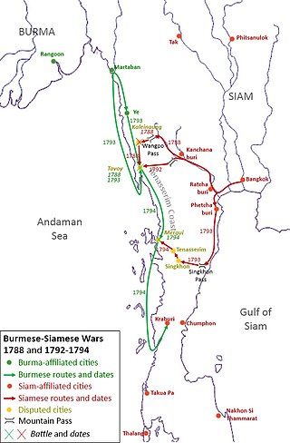
The Burmese–Siamese War (1792–1794) or the Siamese Invasion of Tavoy was the conflict between the Kingdom of Burma under Konbaung dynasty and the Kingdom of Siam under the Chakri dynasty over the town of Tavoy and the Tenasserim Coast.

The Tavoy campaign of 1788 was a conflict between the Kingdom of Burma under Konbaung dynasty and the Kingdom of Siam under the Chakri dynasty over the town of Tavoy and the Tenasserim Coast.
Htikhi is a town in Dawei Township, Tanintharyi Region, Myanmar. The town is home to Phu Nam Ron, one of 7 official border trade posts with Thailand. In 2022, total trade volume at the border post stood at US$2.563 billion, making it the busiest border post with Thailand. As of September 2019, the road from Myitta, the closest Burmese town, which is 101 kilometres (63 mi) away, remained unpaved. A roads project was initiated in 2019, to link Htikhi to the Dawei Special Economic Zone. Htee Khee was formerly the headquarters of the Karen National Union's 4th brigade until 2012.


