
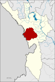
Chin State is a state in western Myanmar. The 36,019-square-kilometre (13,907 sq mi) Chin State is bordered by Sagaing Division and Magway Division to the east, Rakhine State to the south, Bangladesh to the south-west, and the Indian states of Mizoram to the west and Manipur to the north. The population of Chin state is about 478,801 in 2014 census. The capital of the state is Hakha. The state is a mountainous region with few transportation links. Chin State is sparsely populated and remains one of the least developed areas of the country. Chin State has the highest poverty rate of 73% as per the released figures from the first official survey. The official radio broadcasting dialect of Chin is Falam. There are 53 different subtribes and languages in Chin State. There are nine townships in Chin State. Hakha, Thantlang, Falam, Tedim, Tonzang, Matupi, Mindat, Kanpetlet and Paletwa townships. In 1896, Mindat and Kanpetlet were placed under Pakokku Hill Tracts District of British Burma later emerged into Chin hills. Only Paletwa township became a part of Arakan Hill Tracts District of British Burma.
Mae Sot is a district in western Thailand that shares a border with Myanmar to the west. It is notable as a trade hub and for its substantial population of Burmese migrants and refugees. The town is part of Tak Province and is the main gateway between Thailand and Myanmar. As a result, it has gained notoriety for its trade in gems and teak, as well as black market services such as people trafficking and drugs. Neighbouring districts are : Mae Ramat, Mueang Tak, and Phop Phra. The Moei River serves as a natural border between Mae Sot and the Burmese town of Myawaddy.

The Zou people are an indigenous community living along the frontier of India and Burma, they are a sub-group of the Zo people (Mizo-Kuki-Chin). In India, they live with and are similar in language and habits to the Paite and the Simte peoples. In Burma, the Zou are counted among the Chin people.They are a hill people, "Zou" means "Hills" so we can say that the Zous are "people of the hills" or "of the hills" and "Zou" has also a different meaning in Zou language that is "complete" or another word for it is "finish". But when it comes to the identification of the Zous or their tribe it is simply "Hills" or "of the hills", "people of the hills" or "Hill people". The Zous can be found in different parts of India and also of the world.

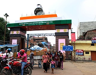
Moreh is a town located on the India–Myanmar border in the Tengnoupal district of the Indian state of Manipur. Moreh is a town located in Indo-Myanmar in the Tengnoupal district of Indian State Manipur. The town is mainly inhabited by Kuki community and sizeable population of Meitei, Nepali, Tamil, Punjabi, Telugu, Muslim Pangal, Bihari, Marwari. Moreh plays a very important role in Indo-Myanmar relationship and also rapidly developing as a trade point in India on the border of Myanmar. Moreh is already a huge commercial hub, and economists suggested that it could become a bustling city in the next couple of decades. The town is already seen as the commercial capital of Manipur and India's Gateway to South-East Asia.
The Ministry of Development of North Eastern Region is a Government of India ministry, established in September 2001, which functions as the nodal Department of the Central Government to deal with matters related to the socio-economic development of the eight States of Northeast India: Arunachal Pradesh, Assam, Manipur, Meghalaya, Mizoram, Nagaland, Tripura and Sikkim. It acts as a facilitator between the Central Ministries/ Departments and the State Governments of the North Eastern Region in the economic development including removal of infrastructural bottlenecks, provision of basic minimum services, creating an environment for private investment and to remove impediments to lasting peace and security in the North Eastern Region.
Behiang is a border village in Manipur, India on the boundary with Burma. With roughly 1,000 size population, this village snakes for about 2 km. along the Tedim road. Majority of the local population belongs to the ZOMI community.

Attari, also spelled Atari, Punjabi:ਅਟਾਰੀ is a village of Amritsar district in the Punjab state of India, 3 km from the Indo-Pakistani border at Wagah. It is situated 25 km west of the Sikh holy city of Amritsar, and is the last Indian station on the rail route connecting Lahore, Pakistan with the Indian capital Delhi. Attari village was the native village of Sardar Sham Singh Attariwala, one of the generals in the Army of Maharaja Ranjit Singh.

India–Myanmar relations, also knows as Indian–Burmese relations or Indian–Myanmar relations, refers to the bilateral relations between India and Myanmar. These relations encompass the political, economic and socio-cultural relations that exist between the two neighboring Asian countries. Political relations have improved considerably since 1993, overcoming tensions related to drug trafficking, the suppression of democracy and the rule of the military junta in Myanmar. Political leaders from both countries meet regularly on a bilateral basis and within the ASEAN Plus Six community. Economic relations are considerable with India representing Myanmar's 4th largest export market and the country's 5th largest import partner.

Dawki or Dauki is a town in West Jaintia Hills district, Meghalaya, India.

Hili is a village in Hili CD Block in Balurghat subdivision of Dakshin Dinajpur district in the Indian state of West Bengal. It is a border checkpoint on the India-Bangladesh border.
The Bangladesh–India border, known locally as the International Border (IB), is an international border running between Bangladesh and India that demarcates the eight divisions of Bangladesh and the Indian states.
Sonauli is a town area in Maharajganj district in Uttar Pradesh. It located on the Indo-Nepal Border and is a well-known and most famous transit point between India and Nepal.

The Kaladan Road Project is a US$484 million project connecting the eastern Indian seaport of Kolkata with Sittwe seaport in Rakhine State, Myanmar by sea. In Myanmar, it will then link Sittwe seaport to Paletwa in Chin State via the Kaladan river boat route, and then from Paletwa by road to Mizoram state in Northeast India. Originally, the project was scheduled to be completed by 2014, but is expected to be operational only by 2019–2020 as all components of the project, including Sittwe port and power, river dredging, Paletwa jetty, have been completed, except the under construction Zorinpui-Paletwa road, construction of which commenced in April 2018.

The India–Myanmar–Thailand Trilateral Highway is a highway under construction under India's Look East policy that will connect Moreh, India with Mae Sot, Thailand via Myanmar. Imphal-Mandalay-Bangkok 55 km (34 mi) route, consisting of Imphal-Mandalay 584 km (363 mi) and Mandalay-Bangkok 1,397 km (868 mi), is a highway in good condition except for 101 km (63 mi) part of 120 km (75 mi) long Kalewa-Yagyi stretch being upgraded to 2-lane in each direction highway by India.
Hmawngbuchhuah is a village in Lawngtlai Block in Lawngtlai district in the state of Mizoram, India.
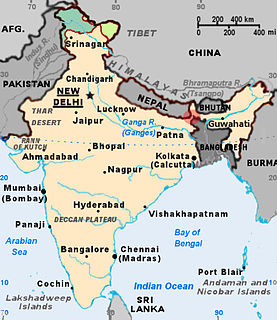
India shares borders with several sovereign countries; it shares land borders with China, Bhutan, Nepal, Afghanistan and Pakistan in the north or north-west, and with Bangladesh and Myanmar in the east. India also shares maritime borders with Sri Lanka.
Mahadipur is a village in English Bazar CD block in Malda Sadar subdivision of Malda district in the state of West Bengal, India and is a border checkpoint, on the Indian side of the Bangladesh-India border, with Sonamosjid in Chapai Nawabganj District on the Bangladesh side.

The Land Ports Authority of India or LPAI is a statutory body working under the Ministry of Home Affairs, Government of India is responsible for creating, upgrading, maintaining and managing border infrastructure in India. It managess several Integrated Check Posts (ICPs) all across Borders of India.
India-China Border Roads (ICBR) project is a Government of India project which aims to develop the infrastructure along the Sino-Indian border by constructing "strategic roads". Several entities are responsible for constructing ICBR, including Border Roads Organisation (BRO) which handles the bulk of the ICBR road construction work, NHAI, MoDNER, Central Public Works Department (CPWD), National Projects Construction Corporation (NPCC), PWDs of respective states and others. China in comparison, has significantly upgraded infrastructure in the Tibetan Autonomous Region with five airbases, an extensive rail network and more than 58,000 km of roads.

The India–Myanmar border is the international border between the India and Myanmar. The border is 1,468 km (912 mi) in length and runs from the tripoint with China in the north to the tripoint with Bangladesh in the south.
