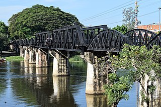
The Burma Railway, also known as the Siam–Burma Railway, Thai–Burma Railway and similar names, or as the Death Railway, is a 415 km (258 mi) railway between Ban Pong, Thailand, and Thanbyuzayat, Burma. It was built from 1940 to 1943 by South East Asian civilians abducted and forced to work by the Japanese and a smaller group of captured Allied soldiers, to supply troops and weapons in the Burma campaign of World War II. It completed the rail link between Bangkok, Thailand, and Rangoon, Burma. The name used by the Japanese Government was Tai–Men Rensetsu Tetsudō (泰緬連接鉄道), which means Thailand-Burma-Link-Railway.
Chiang Rai is one of Thailand's seventy-six provinces, which lies in upper northern Thailand and is Thailand's northernmost province. It is bordered by the Shan State of Myanmar to the north, Bokeo province of Laos to the east, Phayao to the south, Lampang to the southwest, and Chiang Mai to the west. The provinces is linked to Houayxay Laos by the Fourth Thai–Lao Friendship Bridge that spans the Mekong.

Kanchanaburi is the largest of the western provinces (changwat) of Thailand. The neighboring provinces are Tak, Uthai Thani, Suphan Buri, Nakhon Pathom, and Ratchaburi. In the west it borders Kayin State, Mon State, and the Tanintharyi Region of Myanmar.

Three Pagodas Pass is a pass in the Tenasserim Hills on the border between Thailand and Myanmar (Burma), at an elevation of 282 metres (925 ft). The pass links the town of Sangkhla Buri in the north of Kanchanaburi Province, Thailand, to the town of Payathonsu in the south of Kayin State, Myanmar.

Dawei is a city in south-eastern Myanmar and is the capital of the Tanintharyi Region, formerly known as the Tenasserim Division, on the eastern bank of the Dawei River. The city is about 614.3 km (381.7 mi) southeast of Yangon. Its population is 146,964. Dawei is a port at the head of the Dawei River estuary, 30 km (18.6 mi). from the Andaman Sea. As a result, the city is prone to flooding during the monsoon season. Dawei People is also the name of one of Myanmar's 135 ethnic minorities.

Sangkhla Buri is a district (amphoe) in Kanchanaburi province in western Thailand.
Mae Sot is a district in western Thailand that shares a border with Myanmar to the west, and has been described "an almost entirely Burmese town". It is notable as a trade hub and for its substantial population of Burmese migrants and refugees. The town is part of Tak province and is the main gateway between Thailand and Myanmar, and is located on the East-West Economic Corridor. As a result, it has gained notoriety for its trade in gems and teak, as well as black market services such as human trafficking and drugs. Neighbouring districts are : Mae Ramat, Mueang Tak, and Phop Phra. The Moei River serves as a natural border between Mae Sot and the Burmese town of Myawaddy.

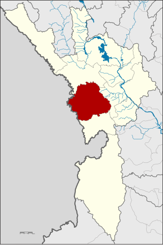
Mueang Kanchanaburi is the capital district of Kanchanaburi province, central Thailand.

Tanintharyi Region is a region of Myanmar, covering the long narrow southern part of the country on the northern Malay Peninsula, reaching to the Kra Isthmus. It borders the Andaman Sea to the west and the Tenasserim Hills, beyond which lie Thailand, to the east. To the north is the Mon State. There are many islands off the coast, the large Mergui Archipelago in the southern and central coastal areas and the smaller Moscos Islands off the northern shores. The capital of the division is Dawei (Tavoy). Other important cities include Myeik (Mergui) and Kawthaung. The division covers an area of 43,344.9 square kilometres (16,735.6 sq mi), and had a population of 1,406,434 at the 2014 Census.
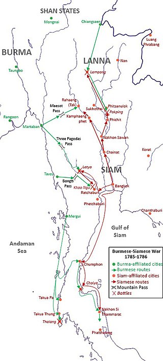
The Burmese–Siamese War (1785–1786), known as the Nine Armies' Wars in Siamese history because the Burmese came in nine armies, was the first war between the Konbaung dynasty of Burma and the Siamese Rattanakosin Kingdom of the Chakri dynasty.
The Tenasserim Hills or Tenasserim Range is the geographical name of a roughly 1,700 km long mountain chain, part of the Indo-Malayan mountain system in Southeast Asia.

Maungmagan is a village and beach located approximately 12 kilometres (7.5 mi) north-west of Dawei, the capital of Taninthayi Division. It is the second oldest beach locale established in Myanmar after Ngapali.

The Luang Prabang Range, named after Luang Prabang, is a mountain range straddling northwestern Laos and Northern Thailand. Most of the range is located in Sainyabuli Province (Laos), as well as Nan and Uttaradit Provinces (Thailand), with small parts in Phitsanulok and Loei Provinces. Several rivers such as the Nan, Pua and Wa rivers, have their sources in this range. Phu Fa waterfall, the biggest and the tallest waterfall in Nan Province, is also located in these mountains. This range is part of the Luang Prabang montane rain forests ecoregion.

Southern Line is a metre-gauge railway line in Thailand, operated by State Railway of Thailand (SRT), which runs through most of the provinces in the Central, Western, and Southern regions of Thailand. At 1,144.29 kilometres in length, it is Thailand's longest railway line.

The China–Myanmar border is the international border between the territory of the People's Republic of China and Myanmar. The border is 2,129 km (1,323 mi) in length and runs from the tripoint with India in the north to the tripoint with Laos in the south.

Ban Kao is a tambon (sub-district) of Mueang Kanchanaburi District, in Kanchanaburi Province, Thailand. In 2017, it had a population of 16,147 people. The tambon contains 15 villages. This network of villages had its origins in northern China and this is reinforced by pottery and ceramic fragments. The pottery and ceramic fragments found at Ban Kao highlight its archaeological significance in Southeast Asia; some of these fragments are currently being kept at the Ban Kao National Museum.
Myitta Subtownship is a subtownship of Dawei Township, Dawei District in the Taninthayi Division of Myanmar. The main town is Myitta (Matamyu), located on the western side of the Tenasserim Range near the confluence of two tributaries of the Great Tenasserim River.
Sinbyudaing, is a small village of Dawei District in the Taninthayi Region of Myanmar. It is located on the western side of the Tenasserim Range near the border with Thailand.

Pilok is a subdistrict (tambon) in Thong Pha Phum District of Thailand's Kanchanaburi Province. Its main settlement, Ban I-tong, is a remote village on the Myanmar border, and is surrounded by Thong Pha Phum National Park, which takes up most of the subdistrict's area. Pilok rose as a mining boomtown in the 1940s, when tin and tungsten mines were established in the area, but suffered greatly from the tin market crash of 1985, after which its mines ceased operation. The village has since seen revival as a tourist destination.
Htikhi is a town in Dawei Township, Tanintharyi Region, Myanmar. The town is home to Phu Nam Ron, one of 7 official border trade posts with Thailand. In 2022, total trade volume at the border post stood at US$2.563 billion, making it the busiest border post with Thailand. As of September 2019, the road from Myitta, the closest Burmese town, which is 101 kilometres (63 mi) away, remained unpaved. A roads project was initiated in 2019, to link Htikhi to the Dawei Special Economic Zone. Htee Khee was formerly the headquarters of the Karen National Union's 4th brigade until 2012.