Kedah, also known by its honorific Darul Aman and historically as Queda, is a state of Malaysia, located in the northwestern part of Peninsular Malaysia. The state covers a total area of over 9,000 km2, and consists of a mainland portion and the Langkawi islands. The mainland has relatively flat terrain, which is used to grow rice, while Langkawi is composed of mostly of uninhabited islands.

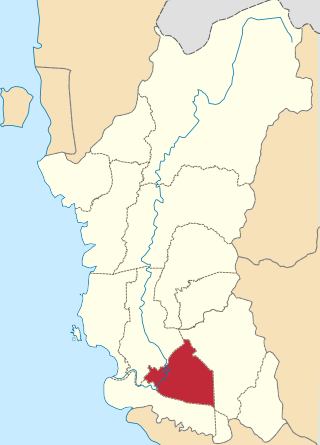
The Baling District is an administrative district in southeastern Kedah, Malaysia. Located about 110 km from Alor Setar, it borders Perak and Betong, the southernmost town of Thailand.
Teluk Intan is a town in Hilir Perak District, Perak, Malaysia. It is the district capital, the largest town in the district and fourth largest town in the state of Perak with an estimated population of around 172,505, more than half of Hilir Perak district's total population (232,900).
Hilir Perak District is a district in Perak, Malaysia. The district is governed by Teluk Intan Municipal Council which is based in the town of Teluk Intan. The District council was known as Hilir Perak District Council until 4 April 2004, when it was upgraded to Municipality status. Teluk Intan town is the district's principal urban center while smaller towns include Langkap town and Chenderong Balai town.

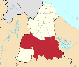
Hulu Perak District is a district in Perak, Malaysia. It is the largest district in Perak. In the east of the district it borders the districts of Jeli and Gua Musang in Kelantan, to the west it borders Baling and Kulim Districts of Kedah, to the south it borders the district of Kuala Kangsar while to the south-west it borders the district of Larut, Matang and Selama. Hulu Perak also shares a border with Yala province's Betong district on the border with Thailand. The seat of the district is Gerik, which is also the largest town of the district.

The Jeli District is a district and a parliamentary constituency in western Kelantan, Malaysia. As of 2010, the district's population is estimated to be 42,150. Jeli is administered by the Jeli District Council. Jeli is bordered by Perak's Hulu Perak District to the west, the Thai district of Waeng to the north, Tanah Merah District to the northeast and Kuala Krai District to the southeast.
Federal Route 77, or Jalan Kroh, is a federal road in Perak, Malaysia. The roads connects Pengkalan Hulu town until Pengkalan Hulu Checkpoint of the Malaysia-Thailand Border. It is a main route to Betong, the southern gateway of Thailand.

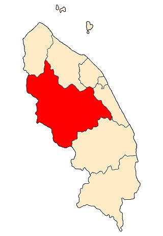
Gerik is a mukim and the district capital of Hulu Perak District, Perak, Malaysia. The town is also known as Rest Town due to its strategic location next to East-West Highway Federal Route 4, the main route linking Kedah, Penang and Kelantan.
Gua Musang is a town, district and parliamentary constituency in southern Kelantan, Malaysia. It is the largest district in Kelantan. Gua Musang is administered by the Gua Musang District Council. Gua Musang district is bordered by the state of Pahang to the south, Terengganu to the east, Perak to the west and the Kelantanese districts of Kuala Krai and Jeli to the north. It is a small railway town about 140 km south of state capital Kota Bharu. Gua Musang is represented by Mohd Azizi Abu Naim in the Dewan Rakyat. The town lies on the KTM East Coast Line, from Tumpat, near the border with Thailand, to Gemas, Negeri Sembilan.

This article lists important figures and events in Malaysian public affairs during the year 1968, together with births and deaths of notable Malaysians.
Hulu Terengganu is an interior district of Terengganu, Malaysia. The seat of the district is Kuala Berang, located about 40 km (25 mi) from the state capital, Kuala Terengganu. The local government of this district is Hulu Terengganu District Council.

Besut is a Kelantanese community district in the Terengganu federal state of Malaysia. It is bordered by the state of Kelantan to the north and west and the South China Sea to the east. It is the northern gateway to Terengganu. Kampung Raja is the district capital, though Jerteh is more developed. Another major town is the fishing port of Kuala Besut. There are other small towns and villages such as Jabi, Apal, Pasir Akar and Tembila.

The Perak River is the second longest river in Peninsular Malaysia after Pahang River in Pahang, Malaysia.

Ampang Jaya, more commonly known as just Ampang, is a town, a mukim and a parliamentary constituency straddling parts of the Hulu Langat District and Gombak District, in eastern Selangor, Malaysia. It is located just outside the eastern border of Kuala Lumpur Federal Territory.
Kroh or Keruh, now known as Pengkalan Hulu, is a town in Hulu Perak District, Perak, Malaysia bordering Thailand and also the state of Kedah. The nearest town on the Thailand side is Betong in Yala province.
High Performance School also known as HPS is a prestigious title conferred to a group of schools in Malaysia that have ethos, character and a unique identity to excel in all aspects of education. The schools have a tradition of high culture and excellent work with the national human capital and continuing to grow holistically and are competitive in the international arena. The title is given by Malaysian Ministry of Education (MOE). This is a section of a part of the National Key Result Areas of Government Transformation Programme (GTP).

The Kingdom of Reman or Kingdom of Rahman was a landlocked semi-independent Malay kingdom in the northern Malay Peninsula.
Reman Malay, also known by several names such as Patani, Baling, Grik and Tukugho, is a Malayic language spoken in the states of Kedah and Perak in northern Peninsular Malaysia. In the state of Kedah it is spoken in the districts of Baling, Padang Terap, Sik and Yan while in Perak it is spoken in Hulu Perak but also in some areas within Kerian and Larut, Matang and Selama districts, especially in the towns of Batu Kurau and Bukit Gantang. Despite being located within these two states, Reman Malay is not closely related to neighbouring Kedahan and Perakian varieties but instead more closely related or an offshoot of Kelantan-Patani Malay.
Batu Kurau is a small town and mukim located in Larut, Matang and Selama district in Perak, Malaysia. It is located 20 km from Taiping, Perak's second largest city.