{{Lang|zh-hant|巴西沙叻}} {{font|size=70%|([[Traditional Chinese characters|Traditional]])}}
''Bāxī Shālè'' {{font|size=70%|([[Hanyu Pinyin]])}}
''baa1 sai1 saa1 lek1'' {{font|size=70%|([[Jyutping]])}}"},"translit_lang1_type4":{"wt":"[[Malaysian Tamil|Tamil]]"},"translit_lang1_info4":{"wt":"{{Lang|ta|பாசிர் சாலாக்}}
''Pācir Cālāk'' {{font|size=70%|([[ISO 15919|Transliteration]])}}"},"settlement_type":{"wt":"Town"},"image_skyline":{"wt":"File:Historical Complex Pasir Salak, Perak - panoramio.jpg"},"imagesize":{"wt":""},"image_alt":{"wt":""},"image_caption":{"wt":"[[Pasir Salak Historical Complex]]"},"image_flag":{"wt":""},"image_seal":{"wt":""},"image_shield":{"wt":""},"etymology":{"wt":""},"nickname":{"wt":""},"motto":{"wt":""},"image_map":{"wt":"{{maplink|frame=yes|plain=yes|type=shape|stroke-width=2|stroke-color=#000000|zoom=13|frame-lat=4.173140|frame-long=100.946720}}"},"map_caption":{"wt":"Location of Pasir Salak in [[Perak]]"},"pushpin_map":{"wt":"Malaysia Perak#Malaysia#Southeast Asia"},"pushpin_mapsize":{"wt":"275px"},"pushpin_map_caption":{"wt":"{{center|{{Legend inline|#800000|outline=black}} '''Pasir Salak''' in {{Legend inline|#FEFEEF|outline=black}} '''[[Perak]]'''}}"},"pushpin_map_alt":{"wt":""},"coordinates":{"wt":"{{coord|4|10|23.304|N|100|56|48.1914|E|region:MY|display=inline,title}}"},"map_alt":{"wt":""},"coor_pinpoint":{"wt":""},"coordinates_footnotes":{"wt":""},"subdivision_type":{"wt":"Country"},"subdivision_name":{"wt":"{{flag|Malaysia}}"},"subdivision_type1":{"wt":"[[States of Malaysia|State]]"},"subdivision_name1":{"wt":"{{flag|Perak}}"},"subdivision_type2":{"wt":"[[Districts of Malaysia|District]]"},"subdivision_name2":{"wt":"[[Perak Tengah District|Perak Tengah]]"},"established_title":{"wt":""},"established_date":{"wt":""},"founder":{"wt":""},"seat_type":{"wt":""},"seat":{"wt":""},"government_footnotes":{"wt":""},"government_type":{"wt":"[[List of local governments in Malaysia|District council]]"},"governing_body":{"wt":"Perak Tengah District Council"},"leader_party":{"wt":""},"leader_title":{"wt":""},"leader_name":{"wt":""},"leader_title1":{"wt":""},"leader_name1":{"wt":""},"unit_pref":{"wt":"Metric"},"area_footnotes":{"wt":""},"area_total_sq_mi":{"wt":"42.0001928"},"area_total_km2":{"wt":"108.78{{cite web | url=https://ptg.perak.gov.my/portal/web/kampong-gajah/geografi-daerah?target=geografidaerah | title=Geografi Daerah - PDT Kampong Gajah - e-Tanah Perak }}"},"area_total_ha":{"wt":""},"length_km":{"wt":""},"width_km":{"wt":""},"dimensions_footnotes":{"wt":""},"elevation_footnotes":{"wt":""},"elevation_m":{"wt":""},"population_footnotes":{"wt":""},"population_as_of":{"wt":"2020"},"population_total":{"wt":"11,900{{Cite web | title=Statistik Daerah - PDT Seri Iskandar - e-Tanah Perak | url=https://ptg.perak.gov.my/portal/web/seri-iskandar/statistik-daerah?target=statistikdaerah | archive-url=https://web.archive.org/web/20210614115000/https://ptg.perak.gov.my/portal/web/seri-iskandar/statistik-daerah?target=statistikdaerah | access-date=2025-03-21 | archive-date=2021-06-14}}"},"population_density_km2":{"wt":"auto"},"population_note":{"wt":""},"population_demonym":{"wt":""},"area_codes":{"wt":""},"timezone":{"wt":"[[Malaysian Standard Time|MST]]"},"utc_offset":{"wt":"+8"},"timezone_DST":{"wt":"Not observed"},"postal_code_type":{"wt":"[[Postal codes in Malaysia|Postcode]]"},"postal_code":{"wt":"36800"},"blank_name":{"wt":"[[Telephone numbers in Malaysia|Area code(s)]]"},"blank_info":{"wt":"05-6xxxxxxx"},"blank1_name":{"wt":"[[Vehicle registration plates of Malaysia|Vehicle registration]]"},"blank1_info":{"wt":"A"},"website":{"wt":""},"footnotes":{"wt":""}},"i":0}}]}" id="mwCA">Town in Perak, Malaysia
Pasir Salak | |
---|---|
Town | |
Other transcription(s) | |
• Jawi | ڤاسير سالق |
• Chinese | 巴西沙叻(Simplified) 巴西沙叻(Traditional) Bāxī Shālè(Hanyu Pinyin) baa1 sai1 saa1 lek1(Jyutping) |
• Tamil | பாசிர் சாலாக் Pācir Cālāk(Transliteration) |
![]() | |
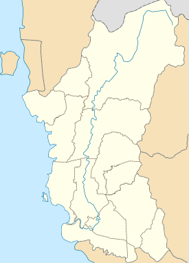
![]() Location of Pasir Salak in Perak | |
Coordinates: 4°10′23.304″N100°56′48.1914″E / 4.17314000°N 100.946719833°E | |
Country | ![]() |
State | ![]() |
District | Perak Tengah |
Government | |
• Type | District council |
• Body | Perak Tengah District Council |
Area | |
• Total | 108.78 [1] km2 (42.0001928 sq mi) |
Population (2020) | |
• Total | 11,900 [2] |
Time zone | UTC+8 (MST) |
• Summer (DST) | Not observed |
Postcode | 36800 |
Area code(s) | 05-6xxxxxxx |
Vehicle registration | A |
Pasir Salak is a mukim and historical riverside town in Perak Tengah District, Perak, Malaysia, about 45 minutes from the state capital, Ipoh.
The British colonial official J.W.W. Birch, who had been sent to take up the position of the first British Resident in Perak, was assassinated at Pasir Salak as the result of a conspiracy involving the local chiefs Dato Maharaja Lela and Sepuntum. The British responded to Birch's assassination with a military intervention during the Perak War. [3]
Today, Pasir Salak is also the name of the parliamentary constituency.