Banting is a town and the seat of Kuala Langat District, Selangor, Malaysia. Banting has a population of 93,497. The postal code for Banting is 42700 and is administered by the Zone of 15 and 19 of the Kuala Langat Municipal Council. It is situated on the banks of Langat River. It is a Rest Town or Bandar Persinggahan of Federal Route 5. The historical Jugra, a former royal town of Selangor is situated near Banting. Banting is located near the beaches of Morib, as well as hills, forest and farms. Banting is an agricultural hub. Its main agricultural resources include oil palm plantations, poultry farms, betel leaves and it has a number of industrial areas. It is also the home town of the Malaysian badminton player Rashid Sidek.
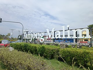
Tanjong Malim, or Tanjung Malim, is a town in Muallim District, Perak, Malaysia. It is approximately 70 km (43 mi) north of Kuala Lumpur and 120 km south of Ipoh via the North–South Expressway. It lies on the Perak-Selangor state border, with Sungai Bernam serving as the natural divider.
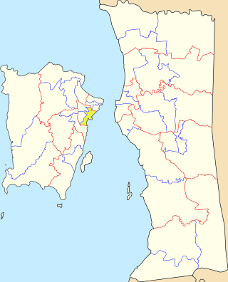
Teluk Intan is a town in Hilir Perak District, Perak, Malaysia. It is the district capital, the largest town in the district and fourth largest town in the state of Perak with an estimated population of around 172,505, more than half of Hilir Perak district's total population (232,900).

Batu Gajah is the seat of Kinta District, Perak, Malaysia. It is administered by the Batu Gajah District Council, formerly known as Kinta West District Council.
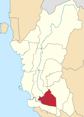
Hilir Perak District is a district in Perak, Malaysia. The district is governed by Teluk Intan Municipal Council which is based in the town of Teluk Intan. The District council was known as Hilir Perak District Council until 4 April 2004, when it was upgraded to Municipality status. Teluk Intan town is the district's principal urban center while smaller towns include Langkap town and Chenderong Balai town.

The North–South Expressway Northern Route is an interstate controlled-access highway running parallel to the northwestern coast of Peninsular Malaysia. The 460-kilometre (290-mile) expressway forms the north section of the North–South Expressway, passing through the northwestern states of Kedah, Penang, Perak and Selangor. The expressway begins at the Bukit Kayu Hitam checkpoint in Kedah, where the Malaysia–Thailand border lies, and ends at Bukit Lanjan in Selangor state where the expressway interchanges with the New Klang Valley Expressway. The expressway is operated by PLUS Expressways.
Second East–West Highway, also known as Simpang Pulai–Kuala Berang Highway, Federal Route 185 and Federal Route 36, is a highway in Peninsular Malaysia which connects Simpang Pulai in Perak to Kuala Jeneris in Terengganu. It overlaps with Federal Route 8 Federal Route 8 between Gua Musang and Sungai Relau. It is notorious for its many sharp corners which increase the risk of road accidents.
Sungai Besi is a town and suburb within the Federal Territory of Kuala Lumpur. The federal constituency of Sungai Besi existed from 1974 to 1995. Sungai Besi was a historical mining town with many heavy industries such as steelworks, waste steel plants and other steel industries. Sungei Besi Tin Mine site was the largest and deepest open cast alluvial tin mine in the world and in Malaysia. The town has since developed from a large area of village settlements.
Gua Musang is a town, district and parliamentary constituency in southern Kelantan, Malaysia. It is the largest district in Kelantan. Gua Musang is administered by the Gua Musang District Council. Gua Musang district is bordered by the state of Pahang to the south, Terengganu to the east, Perak to the west and the Kelantanese districts of Kuala Krai and Jeli to the north. It is a small railway town about 140 km south of state capital Kota Bharu. Gua Musang is represented by Mohd Azizi Abu Naim in the Dewan Rakyat. The town lies on the KTM East Coast Line, from Tumpat, near the border with Thailand, to Gemas, Negeri Sembilan.

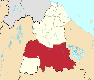
Sungai Siput (U) (Malay for 'snail river', Jawi: سوڠاي سيڤوت; Tamil: சுங்கை சீப்புட்; Chinese: 和豐市/和丰市) is a town and mukim in Kuala Kangsar District, Perak, Malaysia, covering 155.141 hectares, 61.5% of the total area of Kuala Kangsar. Sungai Siput falls under the management of the Kuala Kangsar Municipal Council.

Parit Buntar is a town in Kerian District, Perak, Malaysia. It is bordering to Nibong Tebal in Penang and Bandar Baharu in Kedah.It is also the district capital of Kerian District.

Tapah Road is a small town in Batang Padang District, Perak, Malaysia. The population consists of 40% Muslim Malays, 30% Chinese, 20% Indians and a few indigenous.

Rantau is a small town and a mukim in Seremban District, Negeri Sembilan, Malaysia.
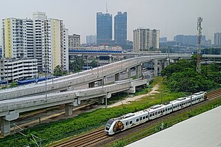
Masjid Jamek LRT station is a rapid transit station in Kuala Lumpur, Malaysia. It is the interchange station between two of Rapid KL's light rapid transit (LRT) systems, namely the LRT Ampang and Sri Petaling Lines and the LRT Kelana Jaya Line. The station is one of only two stations integrating the LRT lines, the other being Putra Heights station. The station is situated near and named after the Masjid Jamek in central Kuala Lumpur.
Federal Route 109, or Jalan Sungai Perak Kanan or Jalan Sungai Manik, is a federal road in Perak, Malaysia. It is also a main route to Pasir Salak Historical Complex in Pasir Salak.
Tanjung Tualang is a mukim in Kinta District, Perak, Malaysia.
Jalan Chikus is a major road in Perak, Malaysia.
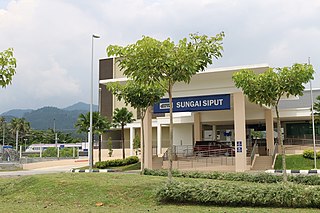
The Sungai Siput railway station is a Malaysian train station located at and named after the town of Sungai Siput, Perak.
Sungai Pinang is a state constituency in Penang, Malaysia, that has been represented in the Penang State Legislative Assembly since 1974. It covers much of Jelutong, one of the suburbs of George Town.
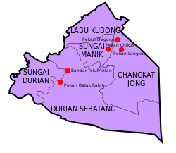
Sungai Manik is a state constituency in Perak, Malaysia, that has been represented in the Perak State Legislative Assembly.