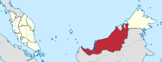
Sarawak is a state of Malaysia. The largest among the 13 states, with an area almost equal to that of Peninsular Malaysia, Sarawak is located in northwest Borneo Island, and is bordered by the Malaysian state of Sabah to the northeast, Kalimantan to the south, and Brunei in the north. The capital city, Kuching, is the largest city in Sarawak, the economic centre of the state, and the seat of the Sarawak state government. Other cities and towns in Sarawak include Miri, Sibu, and Bintulu. As of 2021, the population of Sarawak was estimated to be around 2.45 million. Sarawak has an equatorial climate with tropical rainforests and abundant animal and plant species. It has several prominent cave systems at Gunung Mulu National Park. Rajang River is the longest river in Malaysia; Bakun Dam, one of the largest dams in Southeast Asia, is located on one of its tributaries, the Balui River. Mount Murud is the highest point in the state. Sarawak is the only state of Malaysia with a Christian majority.

East Malaysia, or the Borneo States, also known as Malaysian Borneo, is the part of Malaysia on and near the island of Borneo, the world's third-largest island. Near the coast of Sabah is a small archipelago called Labuan. East Malaysia lies to the east of Peninsular Malaysia, the part of the country on the Malay Peninsula. The two are separated by the South China Sea.

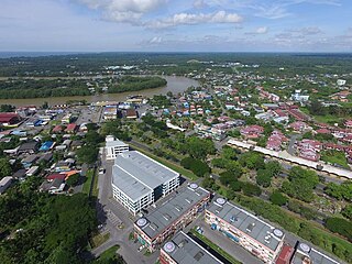
Sibu is a landlocked city in the central region of Sarawak. It is the capital of Sibu District in Sibu Division, Sarawak, Malaysia. The city is located on the island of Borneo and covers an area of 129.5 square kilometres (50.0 sq mi). It is located at the confluence of the Rajang and Igan Rivers, some 60 kilometres from the South China Sea and approximately 191.5 kilometres (119 mi) north-east of the state capital Kuching. Sibu is mainly populated by people of Chinese descent, mainly from Fuzhou. Other ethnic groups such as Iban, Malay and Melanau are also present, but unlike other regions of Sarawak, they are not as significant. The cities population as of 2010 is 162,676.

Miri is a coastal city in northeastern Sarawak, Malaysia, located near the border of Brunei, on the island of Borneo. The city covers an area of 997.43 square kilometres (385.11 sq mi), located 798 kilometres (496 mi) northeast of Kuching and 329 kilometres (204 mi) southwest of Kota Kinabalu. Miri is the second largest city in Sarawak, with a population of 300,543 as of 2020. The city is also the capital of Miri District of the Miri Division.

Sarikei is a town, and the capital of Sarikei District in Sarikei Division, Sarawak, Malaysia. It is located on the Rajang River, near where the river empties into the South China Sea. The district population was 56,798.

Belaga is a district in Kapit Division, Sarawak, Malaysia. It is located on the upper reaches of the Rajang River, some 120 kilometers northeast of Kapit and slightly less than 100 kilometers from the South China Sea coast near Bintulu. It is located within the Hulu Rajang parliamentary constituency.

Bintulu Division is one of the twelve administrative divisions of Sarawak, Malaysia. It has a total area of 12,166.2 square kilometres, and is the third largest division after Kapit Division and Miri Division. Bintulu Division consists of two districts which is Bintulu and Tatau, together with a sub-district under Bintulu, which is Sebauh. Three major towns in Bintulu are Bintulu, Tatau and Sebauh.

Bintulu is a coastal town on the island of Borneo in the central region of Sarawak, Malaysia. Bintulu is located 610 kilometres (380 mi) northeast of Kuching, 216 kilometres (134 mi) northeast of Sibu, and 200 kilometres (120 mi) southwest of Miri. With a population of 114,058 as of 2010, Bintulu is the capital of the Bintulu District of the Bintulu Division of Sarawak, Malaysia.

The Sarawak Corridor of Renewable Energy ("SCORE") is an economic region and development corridor covering central Sarawak, a Malaysian State on the island of Borneo. SCORE was launched in 2008. It is one of the five regional development corridors launched throughout Malaysia during the Abdullah Badawi administration. SCORE is managed by the Regional Corridors Development Authority ("RECODA"), a state government agency created through an Ordinance of the State Legislative Assembly.

Wisma Sanyan was the tallest building in the state of Sarawak, Malaysia from its completion in 2001 to 2019.

Sebauh is a district of Bintulu Division, Sarawak, Malaysia. It shares a boundary with Miri, Baram, Kapit Division, Belaga and Tatau. It has a total area of roughly 5,262.90 square kilometres. Sebauh town is a main administrative and economy centre of Sebauh district.

The Bintulu District is one of two districts of Bintulu Division in Sarawak, Malaysia. It has a total area of 7,220.40 square kilometres. Bintulu District has a sub-district, which is Sebauh. There are two towns in Bintulu District, namely Bintulu, which is the capital of both Bintulu District and Bintulu Division, and Sebauh.

Balingian also known as Kuala Balingian is a town in Sarawak, Malaysia. It lies approximately 286.1 kilometres (178 mi) east-north-east of the state capital Kuching.

Selangau, Sarawak, is a small town located by the Pan Borneo Highway. It is also located by Batang Mukah, a river which flows to the South China Sea. It is located approximately 74 km (46 mi) from Sibu city, 84 km (52 mi) from Mukah town and 134 km (83 mi) from Bintulu town. Selangau town is the administrative centre for the Selangau District.

The Sibu Municipal Council is the municipal council which administers the district of Sibu in the state of Sarawak, Malaysia.

Sibu Rural District Council is a local authority which administers Sibu rural areas such as Sibu Jaya and Selangau District. The agency is under the purview of Ministry of Local Government & Housing Sarawak (MLGH). The establishment of this council is to provide basic amenities, public infrastructure, and professional services to the population under its jurisdiction.

Padawan Municipal Council is a local authority which administers Padawan municipality of the Kuching District, Sarawak, Malaysia. The agency is under the purview of Sarawak Ministry of Local Government and Community Development. MPP headquarters is located at Kota Padawan, at 10th mile away from Kuching city centre. The council aimed to improve infrastructure development and provide quality services to its residents besides preserving the environment.

Mukah (muːkəh), historically known as Muka is a coastal town which serves as the capital and the administrative center of the Mukah Division since 1 March 2002.
Tan Sri Celestine Ujang Jilan was a Malaysian politician from Sarawak. He served as a Sarawak Cabinet Minister (1974–81) including responsible for Housing and Land Development and was later elected Speaker of the Sarawak State Legislative Assembly (1981–87).


