Tampin | |
|---|---|
Town and district capital | |
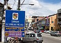
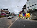
| Tampin Town Bandar Tampin | |
 Downtown Tampin | |
 Logo | |
| Motto(s): Tampin Indah Bersih Selamat (Tampin Beautiful Clean Safe) | |
 Location of Tampin in Negeri Sembilan | |
 Tampin Location of Tampin in Peninsular Malaysia | |
| Coordinates: 2°29′23″N102°14′15″E / 2.48972°N 102.23750°E | |
| Country | |
| State | |
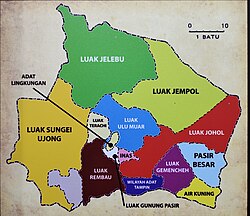
| District | Tampin |
| Luak | |
| Established | 1840 |
| Government | |
| • Type | District council |
| • Body | Tampin District Council |
| • President | Suriani Binti Salihan [1] |
| • Member of Parliament | Mohd Isam Mohd Isa (BN) |
| Area | |
• Total | 149 km2 (58 sq mi) |
| Elevation | 79 m (259 ft) |
| Population (2020) [3] | |
• Total | 31,984 |
| • Density | 215/km2 (556/sq mi) |
| Time zone | UTC+8 (MST) |
| Postcode | 73xxx |
| Website | Tampin District Council |
| Note: The population and land area data of the state constituency of Repah is taken as the population and town area of Tampin, as the Tampin town area is wholly situated within Repah. | |
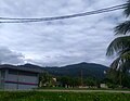
Tampin is a town in Tampin District, Negeri Sembilan, Malaysia, which borders Pulau Sebang town in Alor Gajah District, Malacca. It is situated at the southern tip of the longest mountain range in Malaysia, the Titiwangsa Mountains. [4] [5] [6] [7] [8]
Contents
- Toponymy
- History
- Politics
- Public facilities
- Healthcare
- Police station
- Transport
- Raod link
- Railway
- Bus and taxi
- Education
- Elementary schools
- Secondary schools
- Gallery
- See also
- References
- External links
Tampin is located around 60 km south of the state capital city of Seremban and 30 km northwest of Malacca City, Malacca. The local authority responsible for the town is the Tampin District Council (Malay: Majlis Daerah Tampin).