| Mount Tampin | |
|---|---|
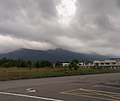
 Mount Tampin dominating the namesake town's skyline, viewed towards north | |
| Highest point | |
| Elevation | 764 m (2,507 ft) |
| Coordinates | 2°30′31″N102°12′42″E / 2.50860°N 102.21170°E |
| Naming | |
| Native name | Gunung Tampin (Malay) |
| Geography | |
 Mount Tampin Location in Malaysia | |
| Location | Tampin District, Negeri Sembilan |
| Parent range | Titiwangsa Mountains |
| Climbing | |
| Easiest route | Hiking |

Mount Tampin (Malay: Gunung Tampin) is a mountain in Tampin District, Negeri Sembilan, Malaysia, close to the border with Malacca.
Contents
- Description
- Tourism and development
- Amenities
- Tampin Layby
- Tampin Xtreme Park
- Tampin Water Park
- Tampin Lake Gardens
- Gallery
- See also
- References
- External links
It is the Hausberg of the namesake town of Tampin, which also serve as the district capital, as well as Pulau Sebang on the Malaccan side.