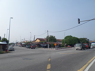
Semenyih is a mukim and town in Hulu Langat District, Selangor, Malaysia along the Kajang–Seremban road highway. The meaning of the name of the town is uncertain and it does not appear in any dictionary. It was derived from the locals and is related to its past. According to an oral story, it is based from a word in the Negeri Sembilan dialect, meaning "hidden" - the standard Malay word for "hidden" will be sembunyi.

Genting Sempah or Sempah Pass is a transit town and also a mountain pass in Bentong District, Pahang, Malaysia. Genting Sempah is mostly known as a transit point to Genting Highlands.

The village of Air Papan is a seaside area with a 3 km long beach set in between the hills in Mersing District, Johor, Malaysia.
Bukit Naning is a main town in Muar District, Johor, Malaysia. It is situated in the parliamentary constituency of Bakri.

Trolak is a small estate town in Muallim District, Perak, Malaysia. It houses many FELDA explorers since circa 1960s with rubber plantation, later changed into oil palm plantation.
Slim is a mukim in Muallim District, Perak, Malaysia. Variant names are Selim, Slim Village, Kampong Slim, and Slin. (Selim is the standard name preferred by the U.S. Board on Geographic Names.
Pasir Panjang is a small town in Port Dickson District, Negeri Sembilan, Malaysia.
Siliau is a small town in Seremban District, Negeri Sembilan, Malaysia. The origin of the name is disputed but one source has it that it derives from the colloquial Hokkien dialect brought by southern Hokkien emigrants to Malaysia in the late 19th century. According to a local tradition, a group of Hokkien emigrants purchased a parcel of land in the Lukut district in 1903 through a middleman. Their intention was to farm the land. When they actually arrived to take possession of their land and saw how barren and infertile it was, one man threw up his hand in despair and said si liau, which is colloquial Hokkien for "we're finished."

Lenggeng is a mukim in Seremban District, Negeri Sembilan, Malaysia.

The Shah Alam Komuter station is a Komuter train station located in Seksyen 19, Shah Alam, Selangor, Malaysia. It is served by the KTM Komuter's Port Klang Line.

Langkap is a small town in Hilir Perak District, Perak, Malaysia.

Sungkai is a mukim in Batang Padang District, Postcode 35600 Perak, Malaysia. It is accessible via the North–South Expressway's Sungkai Interchange.
Ampangan is a mukim in Seremban District, Negeri Sembilan, Malaysia. Ampangan is famous with its pasar malam on every Tuesday and Friday evening. People in the surrounding areas dubbed it as Pasar Malam Ampangan. According to some people the night market has been operating since the 1970s. The night market offers varieties of Malaysian delicacies mostly Malay traditional kuih (deserts). For example:
Paroi is an area in Seremban District, Negeri Sembilan, Malaysia. There are many housing estates and villages. There are many sport facilities built in Paroi especially the state stadium which is Tuanku Abdul Rahman Stadium. Opposite of the stadium, there is a community aquatic centre.
Kampung Sungai Penchala is a small Malay village in the Segambut constituency in northwestern Kuala Lumpur, Malaysia, with the postcode 60000 KUALA LUMPUR, lying along the Federal Territory–Selangor border. This village is next to Taman Tun Dr Ismail in Kuala Lumpur, Malaysia which also shares the same 60000 KUALA LUMPUR postcode, and adjacent to Mutiara Damansara and Bandar Utama that were once part of a large oil palm plantation across the interstate border.
Sikamat is a small town in Negeri Sembilan, Malaysia. It is situated near Seremban. The area contains many government schools and is one of the denser locations for them; SMK Tunku Ampuan Durah, SMK Dato' Sheikh Ahmad, SMK Haji Mohd Redza, SM Sains Tuanku Aishah Rohani (SGS), SM Sains Tuanku Munawir (SASER), SK Sikamat and the Institut Perguruan Raja Melewar, located beside the road towards Masjid Kariah Sikamat.
The 1990 Kuala Lumpur–Karak Highway crash was a highway pile-up took place in Gombak, Selangor, Malaysia on 28 February 1990. About 17 people were killed when the passenger bus collided with a tanker lorry, FRU riot police vehicles, a lorry, two taxis and six cars at kilometre 30.9 of the Kuala Lumpur–Karak Highway about 5 km from Genting Sempah Tunnel at Selangor–Pahang border. 11 FRU riot police personal were killed too. Many vehicles to and from Kuala Lumpur were trapped in a massive jams for five hours. This was the worst highway disaster in Malaysia since Kuala Lumpur–Karak Highway was opened to traffic in 1979.

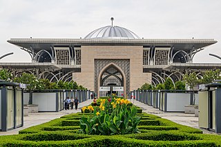
The Tuanku Mizan Zainal Abidin Mosque, or Iron Mosque is the second principal mosque in Putrajaya, Malaysia after Putra Mosque. It is located in Putrajaya's Precinct 3, opposite the Palace of Justice. Construction began since April 2004 and was fully completed on August 2009. It was officially opened by the 13th Yang di-Pertuan Agong, Tuanku Mizan Zainal Abidin on 11 June 2010.

The Governor's Museum is a museum in St. Paul's Hill, Malacca City, Malacca, Malaysia.

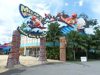
The Melaka Wonderland is a water theme park and resort in Ayer Keroh, Melaka, Malaysia.


