Ayer Kuning | |
|---|---|
 Location of Ayer Kuning in Negeri Sembilan | |
| Country | |
| State | |
| District | Tampin |
| Luak | Ayer Kuning |
Ayer Kuning | |
|---|---|
| Luak Ayer Kuning | |
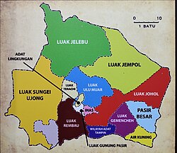 Luak of Ayer Kuning relative to other luaks in Negeri Sembilan | |
| Country | Malaysia |
| State | Negeri Sembilan |
| Adat institution | Undang of Johol |
| Government | |
| • Penghulu | Mohamad Ghazali Abdul Jalil |

Ayer Kuning is a mukim (township) and village in Tampin District, Negeri Sembilan, Malaysia. [1] It borders Nyalas and Asahan, Malacca to the southwest and south, and Jementah, Johor on the southeast.