Satun

Last updated • 1 min readFrom Wikipedia, The Free Encyclopedia
Satun
สตูล
เทศบาลเมืองสตูล
Kuden Mansion.jpg
Satun National Museum
Seal of Satun.png
Thailand adm location map.svg
Red pog.svg
Satun
Location in Thailand
Coordinates: 6°36′53″N100°4′5″E / 6.61472°N 100.06806°E / 6.61472; 100.06806
Country Thailand
Province Satun
District Mueang Satun
Government
  MayorPrasit Baesakul
Population
 (2005)
  Total21,498
Time zone UTC+7 (ICT)
Area code (+66) 74
Website stm.go.th

Satun (Thai : สตูล, pronounced [sā.tūːn] , Malay : Setul) is a town ( thesaban mueang ) in southern Thailand, capital of the Satun province. It covers the whole tambon Phiman of Mueang Satun. Satun lies 985 km south of Bangkok. As of 2005 it has a population of 21,498.

Contents

Climate

Satun has a tropical monsoon climate (Am) with a short dry season in January and February and a prolonged wet season running from March to December. The highest monthly rainfall occurs in September and October with average monthly rainfall above 320 mm. The average annual high temperature in Satun is 32.6 °C and the average annual low temperature is 23.7 °C.

Climate data for Satun (1991–2020, extremes 1978-present)
MonthJanFebMarAprMayJunJulAugSepOctNovDecYear
Record high °C (°F)36.4
(97.5)
37.8
(100.0)
39.5
(103.1)
39.6
(103.3)
38.1
(100.6)
36.8
(98.2)
35.2
(95.4)
35.9
(96.6)
35.3
(95.5)
36.0
(96.8)
36.2
(97.2)
35.1
(95.2)
39.6
(103.3)
Mean daily maximum °C (°F)32.8
(91.0)
34.3
(93.7)
34.9
(94.8)
34.2
(93.6)
33.3
(91.9)
32.6
(90.7)
32.2
(90.0)
32.0
(89.6)
31.7
(89.1)
31.7
(89.1)
31.9
(89.4)
31.7
(89.1)
32.8
(91.0)
Daily mean °C (°F)27.7
(81.9)
28.2
(82.8)
28.6
(83.5)
28.5
(83.3)
28.3
(82.9)
27.9
(82.2)
27.6
(81.7)
27.5
(81.5)
27.1
(80.8)
27.0
(80.6)
27.2
(81.0)
27.2
(81.0)
27.7
(81.9)
Mean daily minimum °C (°F)23.7
(74.7)
23.5
(74.3)
23.7
(74.7)
24.4
(75.9)
24.6
(76.3)
24.3
(75.7)
24.0
(75.2)
24.0
(75.2)
23.8
(74.8)
23.7
(74.7)
23.8
(74.8)
23.6
(74.5)
23.9
(75.1)
Record low °C (°F)17.6
(63.7)
17.0
(62.6)
18.0
(64.4)
19.2
(66.6)
20.8
(69.4)
20.5
(68.9)
21.0
(69.8)
19.2
(66.6)
20.1
(68.2)
20.0
(68.0)
19.4
(66.9)
18.0
(64.4)
17.0
(62.6)
Average precipitation mm (inches)43.6
(1.72)
40.6
(1.60)
133.9
(5.27)
210.3
(8.28)
228.7
(9.00)
189.7
(7.47)
230.4
(9.07)
277.8
(10.94)
334.2
(13.16)
343.8
(13.54)
217.8
(8.57)
118.4
(4.66)
2,369.2
(93.28)
Average precipitation days (≥ 1.0 mm)4.13.58.313.814.913.014.115.717.320.415.410.4150.9
Average relative humidity (%)71.569.273.178.881.682.082.582.684.284.682.177.879.2
Mean monthly sunshine hours 198.4183.6186.0183.0151.9147.0151.9151.9108.0111.6141.0182.91,897.2
Mean daily sunshine hours 6.46.56.06.14.94.94.94.93.63.64.75.95.2
Source 1: World Meteorological Organization [1]
Source 2: Office of Water Management and Hydrology, Royal Irrigation Department (sun 1981–2010) [2] (extremes) [3]

Transportation

Satun is connected to Malaysian Langkawi Island by direct ferry service.

Telecommunication

Satun hosts Thailand's landing points for optical fiber submarine communications cable Segment FEA (FLAG Europe Asia) of the 28,000-kilometer-long FLAG (Fiber-Optic Link Around the Globe); and for the 49,000-kilometer-long SEA-ME-WE 3, which links regions of south-east Asia to regions of the Middle East and Western Europe.

Related Research Articles

<span class="mw-page-title-main">Trang, Thailand</span> City Municipality in Trang, Thailand

Thesaban nakhon Trang, City of Trang, or Trang, also called Mueang Thap Thiang (เมืองทับเที่ยง), is a thesaban nakhon and the capital of Trang Province, Thailand. The city has a population of 59,637 (2005) and covers the whole tambon Thap Thiang of Mueang Trang district. Trang is 839 km south of Bangkok.

<span class="mw-page-title-main">Songkhla</span> City in Thailand

Songkhla, also known as Singgora or Singora, is a city in Songkhla Province of southern Thailand, near the border with Malaysia. Songkhla lies 968 km (601 mi) south of Bangkok and as of 2020 had a population of 61,758.

<span class="mw-page-title-main">Chaiyaphum</span> Town in Thailand

Chaiyaphum is a town in northeastern Thailand, capital of Chaiyaphum Province. As of 2015 it had a population of 58,350, and covers the full tambon Nai Mueang of Mueang Chaiyaphum District. Chaiyaphum is 337 road kilometres northeast of Bangkok.

<span class="mw-page-title-main">Chanthaburi</span> Town in Chanthaburi Province, Thailand

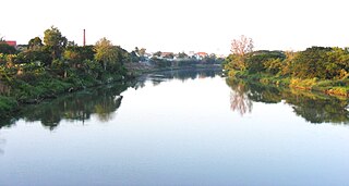
Chanthaburi is a town in the east of Thailand, on the banks of the Chanthaburi River. It is the capital of the Chanthaburi Province and the Mueang Chanthaburi District.

<span class="mw-page-title-main">Uttaradit</span> Provincial Capital City in Uttaradit Province, Thailand

The original name of Mueang district, Uttaradit, was Bang Pho. This district was under the control of Phi Chai District. Later, it was established as Uttaradit Province and Bang Pho District became the capital district. It was changed to Mueang Uttaradit District recently. The district is the seat of government and the center of economic activity of Uttaradit Province. Uttaradit is 483 km north of Bangkok.

<span class="mw-page-title-main">Phetchabun</span> Town in Phetchabun Province, Thailand

Phetchabun is a town in Thailand, capital of Phetchabun Province. It covers the tambon Nai Mueang of the Phetchabun District, along the Pa Sak River. As of 2005, it had a population of 23,823. Phetchabun lies 340 km (210 mi) north of Bangkok.

<span class="mw-page-title-main">Suphan Buri</span> Town in Thailand

Suphan Buri is a town in central Thailand. It covers tambon Tha Philiang and parts of tambons Rua Yai and Tha Rahat, all within the Mueang Suphan Buri District. As of 2006 it had a population of 26,656. The town is 101 km north-northwest of Bangkok.

<span class="mw-page-title-main">Kamphaeng Phet</span> Town in Kamphaeng Phet Province, Thailand

Kamphaeng Phet is a town in central Thailand, former capital of the Kamphaeng Phet Province. It covers the complete tambon Nai Mueang of the Mueang Kamphaeng Phet district. As of 2020, it has a population of 28,817.

<span class="mw-page-title-main">Tak, Thailand</span> Town in Thailand

Tak is a town in north-west Thailand, capital of the Tak Province and the Tak district. As of 2005 the town had a population of 19,900 and an area of 7.27 km2. It covers the tambon Rahaeng, Nong Luang, Chiang Ngoen, and Hua Diat. It is on the Ping River, 418 km north-north-west of Bangkok.

Narathiwat is a town in southern Thailand and capital of Narathiwat Province. The town is in the Mueang Narathiwat District and was established in 1936. As of 2008, the population was 40,521. It lies 1,141 km south of Bangkok.

<span class="mw-page-title-main">Ranong</span> Town in Ranong Province, Thailand

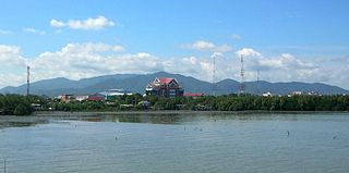
Ranong is a town in southern Thailand, capital of the Ranong Province and the Mueang Ranong District. The town covers completely the area of the tambon Khao Niwet (เขานิเวศน์). As of 2005, it had a population of 16,163. Ranong lies 586 kilometres (364 mi) south-southwest of Bangkok by road.

<span class="mw-page-title-main">Phayao</span> Town in Phayao Province, Thailand

Phayao is a city in northern Thailand, capital of Phayao Province. For administrative purposes the city is divided into 15 sub-districts (tambons), which are further subdivided into 172 administrative villages.

<span class="mw-page-title-main">Chumphon</span> Town in Chumphon Province, Thailand

Chumphon is a town in southern Thailand, capital of the Chumphon Province and Mueang Chumphon District. The city is about 463 kilometers from Bangkok. As of 2018 it had a population of around 33,600. The town covers the commune (tambon) Tha Taphao completely and parts of tambons Bang Mak, Wang Phai, Na Thung, Tak Daet, and Khun Krathing. Its main economic activity is agriculture.

Prachinburi is a town in central Thailand, capital of Prachinburi Province. It covers the entire tambon Na Mueang of the Mueang Prachinburi District. As of 2000, the population of the town was 25,157.

<span class="mw-page-title-main">Nakhon Phanom</span> Town in Nakhon Phanom Province, Thailand

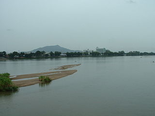
Nakhon Phanom is a town in northeastern Thailand, capital of Nakhon Phanom Province. The town covers tambons Nai Mueang and Nong Saeng and parts of tambons At Samat and Nong Yat, all in Mueang Nakhon Phanom District. As of 2006, it had a population of 27,591. This town is located 736 kilometres (457 mi) northeast of Bangkok.

<span class="mw-page-title-main">Roi Et</span> Town in Roi Et Province, Thailand

Roi Et is a town in north-eastern Thailand, capital of Roi Et province. It covers the whole tambon Nai Mueang of Mueang Roi Et district. As of 2006 it had a population of 34,229. Roi Et is 514 km from Bangkok, and is served by Roi Et Airport.

<span class="mw-page-title-main">Mueang Ubon Ratchathani district</span> District in Ubon Ratchathani, Thailand

Mueang Ubon Ratchathani is the capital district of Ubon Ratchathani province, northeastern Thailand.

<span class="mw-page-title-main">Chonburi</span> City in Thailand

Chonburi is the capital of Chonburi Province and, as part of the district Mueang Chonburi, the seventh-largest city in Thailand. It is about 100 km southeast of Bangkok, on the coast of the Gulf of Thailand, and has an urban population of 342,959. Its name means 'city of water'.

<span class="mw-page-title-main">Nakhon Sawan</span> City Municipality in Thailand

Nakhon Sawan is a city in Thailand. The name literally means "Heavenly City". The city is the capital of Nakhon Sawan province, and covers the complete subdistrict (tambon) of Pak Nam Pho and parts of Khwae Yai, Nakhon Sawan Tok, Nakhon Sawan Ok and Wat Sai, as well as all of Mueang Nakhon Sawan district. As of 31 December 2020, it has a population of 82,305. Nakhon Sawan is 238 km north of Bangkok.

<span class="mw-page-title-main">Phuket (city)</span> City in Thailand

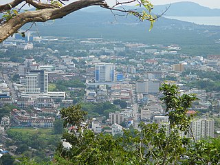
Phuket is a city in the southeast of Phuket Island, Thailand, and the capital of Phuket province. As of 2020 the city had a population of 79,308. It covers the subdistricts (tambons) Talat Yai and Talat Nuea of Mueang Phuket district.

References

  1. "World Meteorological Organization Climate Normals for 1991–2020". World Meteorological Organization. Retrieved 12 October 2023.
  2. "ปริมาณการใช้น้ำของพืชอ้างอิงโดยวิธีของ Penman Monteith (Reference Crop Evapotranspiration by Penman Monteith)" (PDF) (in Thai). Office of Water Management and Hydrology, Royal Irrigation Department. p. 125. Retrieved 8 August 2016.
  3. "Climatological Data for the Period 1981–2010". Thai Meteorological Department. Retrieved 4 August 2016.

6°36′53″N100°4′5″E / 6.61472°N 100.06806°E / 6.61472; 100.06806