
The National Meat Institute (Instituto Nacional de Carnes, INAC) is a governmental agency of Uruguay. Its headquarters are in Rincon Str. 545, Ciudad Vieja, Montevideo. [1] Decree-Law No. 15,605 of July 27, 1984 created the agency. [2]
The National Meat Institute (Instituto Nacional de Carnes, INAC) is a governmental agency of Uruguay. Its headquarters are in Rincon Str. 545, Ciudad Vieja, Montevideo. [1] Decree-Law No. 15,605 of July 27, 1984 created the agency. [2]

The University of the Republic is Uruguay's oldest public university. It is by far the country's largest university, as well as the second largest public university in South America and the world's 57th largest by enrollment, with a student body of 137,757 undergraduate students in 2018 and 6,351 postgraduate students in 2012. It was founded on 18 July 1849 in Montevideo, where most of its buildings and facilities are still located. Its current rector is Rodrigo Arim.

Montevideo is a department (departamento) of Uruguay. It is by far the smallest one in area but the most populated as well. It contains the city of Montevideo, capital of Uruguay. While most of the department is covered by the capital city, there are still smaller towns within its limits.

The Montevideo Uruguay Temple is the 103rd operating temple of The Church of Jesus Christ of Latter-day Saints.

Ciudad Vieja is the name of the oldest part of the city of Montevideo, capital city of Uruguay. Nowadays, Ciudad Vieja is a barrio of this city. In the last couple of years it has gone through a major transformation that has made it the main nightlife centre in town. It is in this area where most of the nightclubs are, and also it hosts the 'Mercado del Puerto' a traditional venue for Uruguayan food and beverages. The main port of Uruguay is located in Ciudad Vieja.

Solís Theatre is Uruguay's most important and renowned theatre. It opened in 1856 and the building was designed by the Italian architect Carlo Zucchi. It is located in Montevideo's Old Town, right next to the Plaza Independencia.
Plaza Independencia is the name of Montevideo's most important plaza. It separates Ciudad Vieja from downtown Montevideo, with the Gateway of The Citadel on one side and the beginning of 18 de Julio avenue on the other.

The Legislative Palace in Montevideo, Uruguay, is the site where the Uruguayan parliament meets.

Parque Prado is the largest of Montevideo's six principal public parks. Established in 1873, it covers an area of 106 hectares and is located in the barrio of Prado. Located in the northern part of the city, the Miguelete Creek flows through the neighbourhood and park of the same name.

The Port of Montevideo, in the northern part of the Old City of Montevideo, Uruguay, is one of the major ports of South America and plays a very important role in the economy of Uruguay.

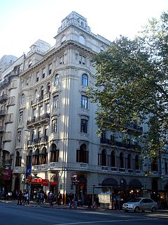
Edificio Lapido is a building on the 18 de Julio Avenue in Centro, Montevideo, Uruguay.

Route 5 is a national route of Uruguay. In 1975, it was assigned the name Brigadier General Fructuoso Rivera, a national hero of Uruguay. It is one of the most important highways in country, along with Route 3, connecting Montevideo in the south with Rivera in the north and passing through the centre of the country. The road is approximately 501 kilometres (311 mi) in length. Upon reaching Santana do Livramento, the road joins federal highway BR-158.
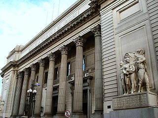
Casa Central del Banco República is a building, seat of the administration of the Banco de la República Oriental del Uruguay. It is located in Ciudad Vieja of Montevideo, Uruguay.
Palacio Chiarino is a French Neoclassical building located on the corner of Plaza de Cagancha and Avenue 18 de Julio in the center of Montevideo, Uruguay. Its construction began in 1922 and finished in 1928. The architects Antonio Chiarino, Bartolome Triay and Gaetano Moretti was commissioned to create the design for the Arturo Soneira family. Moretti died before the building was completed. Moretti also designed Palcio Legislativo in Montevideo, Uruguay.

The Church of Saint Michael Garicoits, popularly known as Iglesia de los Vascos is a Roman Catholic parish church in Montevideo, Uruguay.

Sacred Heart Church, popularly known as Iglesia del Seminario, is a Roman Catholic parish church in Montevideo, Uruguay. It was established on 9 April 1891.
The Church of Our Lady of Lourdes and Saint Vincent Pallotti, popularly known as Iglesia de Lourdes, is a Roman Catholic parish church in Montevideo, Uruguay.

The Cathedral of The Most Holy Trinity, popularly known as "Templo Inglés", is an Anglican church in Montevideo, Uruguay.

The Sanctuary Chapel of Mother Francesca Rubatto is a Roman Catholic chapel in Montevideo, Uruguay.

The Sanctuary of the Miraculous Medal and Saint Augustine, popularly known as Iglesia de la Unión is a Roman Catholic parish church in Montevideo, Uruguay.
Arroyo de las Piedras is a river in Uruguay.
Coordinates: 34°54′22.5″S56°12′16″W / 34.906250°S 56.20444°W
| This meat-related article is a stub. You can help Wikipedia by expanding it. |
| This article about government in Uruguay is a stub. You can help Wikipedia by expanding it. |