
The national parks of Scotland are managed areas of outstanding landscape where some forms of development are restricted to preserve the landscape and natural environment. At present, Scotland has two national parks: Loch Lomond and The Trossachs National Park, created in 2002, and the Cairngorms National Park, created in 2003.
A heritage coast is a strip of coastline in England and Wales, the extent of which is defined by agreement between the relevant statutory national agency and the relevant local authority. Such areas are recognised for their natural beauty, wildlife and heritage and amongst the purposes of definition is support for these qualities and enabling enjoyment of them by the public. For England this national agency is Natural England and for Wales it is Natural Resources Wales.

Protected areas of the United Kingdom are areas in the United Kingdom which need and /or receive protection because of their environmental, historical or cultural value to the nation. Methods and aims of protection vary depending on the nature and importance of the resource. Protection operates at local, regional, national and international levels, and may be backed by legislation and international treaty, or less formally by planning policy.

NatureScot is the operating name for the body formally called Scottish Natural Heritage. It is an executive non-departmental public body of the Scottish Government responsible for the country's natural heritage, especially its natural, genetic and scenic diversity. It advises the Scottish Government on nature conservation, and acts as a government agent in the delivery of conservation designations, i.e. national nature reserves, local nature reserves, national parks, Sites of Special Scientific Interest (SSSIs), Special Areas of Conservation, Special Protection Areas and the national scenic areas. It receives annual funding from the Government in the form of Grant in Aid to deliver Government priorities for the natural heritage.
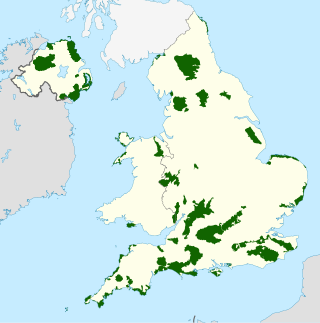
An Area of Outstanding Natural Beauty is one of 46 areas of countryside in England, Wales, or Northern Ireland that has been designated for conservation due to its significant landscape value. Since 2023, the areas in England and Wales have also adopted the name National Landscapes.
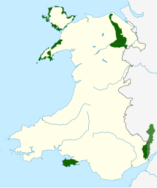
There are five Areas of Outstanding Natural Beauty (AONBs) in Wales, known from November 2023 as National Landscapes. AONBs are areas of countryside that have been designated for statutory protection, due to their significant landscape value, by initially the Government of the United Kingdom and later Welsh devolved bodies. Of the current five areas designated, four are wholly in Wales, with another spanning the Wales-England border, and in total AONBs account for 4% of Wales' land area.
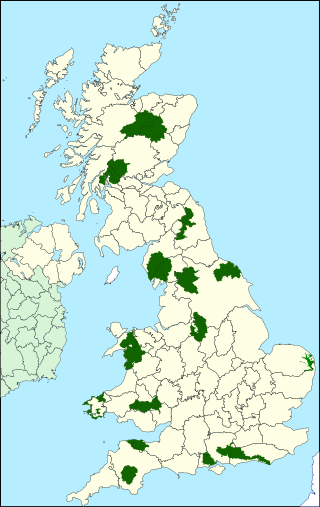
National parks of the United Kingdom are 15 areas of relatively undeveloped and scenic landscape across the country. Despite their name, they are quite different from national parks in many other countries, which are usually owned and managed by governments as protected community resources, and which do not usually include permanent human communities. In the United Kingdom, an area designated as a national park may include substantial settlements and human land uses that are often integral parts of the landscape. Land within national parks remains largely in private ownership. These parks are therefore not "national parks" according to the internationally accepted standard of the IUCN but they are areas of outstanding landscape where planning controls are a little more restrictive than elsewhere.

The Solway Coast is a designated Area of Outstanding Natural Beauty in northern Cumbria, England. It incorporates two areas of coastline along the Solway Firth, the first running from just north of the city of Carlisle, at the estuary of the rivers Esk and Eden, in a westerly direction as far as Silloth-on-Solway, including the villages of Bowness-on-Solway, Burgh-by-Sands, Port Carlisle, and Skinburness. The second area begins just north of the hamlet of Beckfoot, and runs south down the coast to the southern end of Allonby Bay near the village of Crosscanonby. Included in this area are the villages of Mawbray and Allonby, and the hamlets of Dubmill, Hailforth and Salta. The hamlet of Wolsty lies just outside the AONB. Beginning at Silloth, the B5300 coast road runs in a south-westerly direction, entering the AONB just north of Beckfoot, and exiting near Crosscanonby.
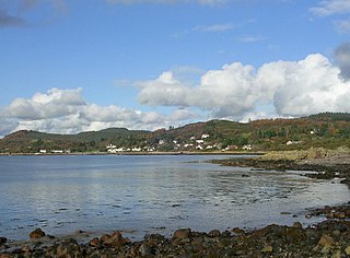
Rough Firth is an inlet on the northern coast of the Solway Firth in the Stewartry area of Dumfries and Galloway, Scotland. The firth lies between Almorness Point and Castlehill Point, and contains Rough Island. The village of Kippford stands near the head of the firth where the Urr Water reaches the sea; the only other coastal settlement of any size is Rockcliffe. The area is designated as the East Stewartry Coast National Scenic Area, one of the forty national scenic areas (NSAs) in Scotland.

South Lewis, Harris and North Uist is a large national scenic area (NSA) in the Western Isles of Scotland. It is one of 40 such areas in Scotland, which are defined so as to identify areas of exceptional scenery and to ensure its protection from inappropriate development. The designated area covers 202,388 ha in total, of which 112,301 ha is on land, with a further 90,087 ha being marine, making it the largest of the NSAs in both total and marine area. The designated area includes the mountainous south west of Lewis, all of Harris, the Sound of Harris and the northern part of North Uist.

Wales, a country that is part of the United Kingdom, contains protected areas under various designations. The largest designation by land area is Wales' three national parks, followed by the five Areas of Outstanding Natural Beauty.

The Cornwall National Landscape covers 958 square kilometres (370 sq mi) in Cornwall, England, United Kingdom; that is, about 27% of the total area of the county. It comprises 12 separate areas, designated under the National Parks and Access to the Countryside Act 1949 for special landscape protection. Of the areas, eleven cover stretches of coastline; the twelfth is Bodmin Moor. The areas are together treated as a single Area of Outstanding Natural Beauty (AONB): all AONBs have been rebranded as National Landscapes since November 2023. Section 85 of the Countryside and Rights of Way Act 2000 places a duty on all relevant authorities when discharging any function affecting land within an AONB to have regard to the purpose of conserving and enhancing natural beauty. Section 89 places a statutory duty on Local Planning Authorities with an AONB within their administrative area to produce a 5-year management plan.

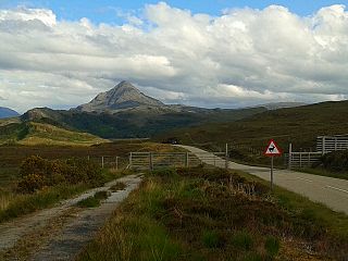
National scenic area (NSA) is a conservation designation used in Scotland, and administered by NatureScot on behalf of the Scottish Government. The designation's purpose is to identify areas of exceptional scenery and to protect them from inappropriate development. There are currently 40 national scenic areas (NSAs) in Scotland, covering 13% of the land area of Scotland. The areas protected by the designation are considered to represent the type of scenic beauty "popularly associated with Scotland and for which it is renowned". As such they tend to be mainly found in remote and mountainous areas, with a review in 1997 noting a potential weakness of national scenic areas was that the original selection placed undue emphasis on mountainous parts of the country. National scenic areas do however also cover seascapes, with approximately 26% of the total area protected by the designation being marine. The designation is primarily concerned with scenic qualities, although designated national scenic areas may well have other special qualities, for example related to culture, history, archaeology, geology or wildlife. Areas with such qualities may be protected by other designations that overlap with the NSA designation.
Many parts of Scotland are protected in accordance with a number of national and international designations because of their environmental, historical or cultural value. Protected areas can be divided according to the type of resource which each seeks to protect. NatureScot has various roles in the delivery of many environmental designations in Scotland, i.e. those aimed at protecting flora and fauna, scenic qualities and geological features. Historic Environment Scotland is responsible for designations that protect sites of historic and cultural importance. Some international designations, such as World Heritage Sites, can cover both categories of site.

Ben Nevis and Glen Coe is a national scenic area (NSA) covering part of the Highlands of Scotland surrounding Ben Nevis and Glen Coe, in which certain forms of development are restricted. It is one of 40 such areas in Scotland, which are defined so as to identify areas of exceptional scenery and to ensure their protection from inappropriate development. The Ben Nevis and Glen Coe NSA covers 903 km2 (349 sq mi) of land, lying within the Highland, Argyll and Bute and Perth and Kinross council areas. A further 19 km2 (7.3 sq mi) of the NSA are marine, covering the sea loch of Loch Leven.

Hoy and West Mainland is a national scenic area (NSA) covering parts of the islands of Hoy and Mainland in the Orkney Islands of Scotland, as well as parts of the surrounding sea. It is one of 40 such areas in Scotland, which are defined so as to identify areas of exceptional scenery and to ensure its protection by restricting certain forms of development. The Hoy and West Mainland NSA covers 24,407 ha in total, consisting of 16,479 ha of land with a further 7928 ha being marine.

Morar, Moidart and Ardnamurchan is a national scenic area (NSA) covering the coastal scenery of three peninsulas in the western Highlands of Scotland: Ardnamurchan, Moidart and Morar. It is one of 40 such areas in Scotland, which are defined so as to identify areas of exceptional scenery and to ensure its protection from inappropriate development by restricting certain forms of development. The Morar, Moidart and Ardnamurchan NSA covers 36,956 ha in total, consisting of 17,220 ha of land with a further 19,736 ha being marine.
North West Sutherland is a national scenic area (NSA) covering the mountains and coastal scenery of the northwestern part of the county of Sutherland in the highlands of Scotland. The designated area covers the mountains of Foinaven, Arkle and Ben Stack as well as the coastal scenery surrounding Loch Laxford and Handa Island. It is one of 40 such areas in Scotland, which are defined so as to identify areas of exceptional scenery and to ensure its protection by restricting certain forms of development. The North West Sutherland NSA covers 26,565 ha in total, consisting of 23,415 ha of land with a further 3,151 ha being marine.

Scarba, Lunga and the Garvellachs is the name of one of the 40 national scenic areas of Scotland. The designated area covers the islands of Scarba, Lunga, and the Garvellachs, all of which lie in the Firth of Lorn, along with much of the surrounding seascape. The national scenic areas are defined so as to identify areas of exceptional scenery and to ensure its protection by restricting certain forms of development, and are considered to represent the type of scenic beauty "popularly associated with Scotland and for which it is renowned". The Scarba, Lunga and the Garvellachs NSA covers 6,542 ha in total, consisting of 2,139 ha of land with a further 4,402 ha being marine.

The Upper Tweeddale National Scenic Area lies in the Borders region of Scotland. It is one of 40 national scenic areas (NSA) in Scotland, which are defined so as to identify areas of exceptional scenery and to ensure their protection from inappropriate development. The designated area covers 12,770 ha of countryside surrounding the upper reaches of the River Tweed between Broughton and Peebles.

