Related Research Articles
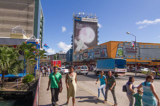
Suva is the capital and largest city of Fiji. It is the home of the country's largest metropolitan area and serves as its major port. The city is located on the southeast coast of the island of Viti Levu, in Rewa Province, Central Division.

Lautoka is the second largest city in Fiji. It is on the west coast of the island of Viti Levu, in the Ba Province of the Western Division. Lying in the heart of Fiji's sugar cane-growing region, the city has come to be known as the Sugar City. Covering an area of 32 square kilometres, it had a population of 71,573 at the 2017 census, the most recent to date.

The Republic of Minerva was a micronation consisting of the Minerva Reefs. It was one of the few modern attempts at creating a sovereign micronation on the reclaimed land of an artificial island in 1972. The architect was Las Vegas real estate millionaire and political activist Michael Oliver, who went on to other similar attempts in the following decade. Lithuanian-born Oliver formed a syndicate, the Ocean Life Research Foundation, which had considerable finances for the project and had offices in New York and London. They anticipated a libertarian society with "no taxation, welfare, subsidies, or any form of economic interventionism." In addition to tourism and fishing, the economy of the new nation would include light industry and other commerce.
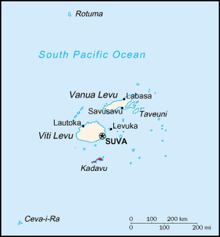
Kadavu, with an area of 411 square kilometres (159 sq mi), is the fourth largest island in Fiji, and the largest island in the Kadavu Group, a volcanic archipelago consisting of Kadavu, Ono, Galoa and a number of smaller islands in the Great Astrolabe Reef. Its main administrative centre is Vunisea, which has an airport, a high school, a hospital, and a government station, on the Namalata Isthmus where the island is almost cut in two. Suva, Fiji's capital, lies 88 kilometres to the north of Kadavu. The population of the island province was 10,167 at the most recent census in 2007.
The Lau Islands of Fiji are situated in the southern Pacific Ocean, just east of the Koro Sea. Of this chain of about sixty islands and islets, about thirty are inhabited. The Lau Group covers a land area of 188 square miles, and had a population of 10,683 at the most recent census in 2007. While most of the northern Lau Group are high islands of volcanic origin, those of the south are mostly carbonate low islands.
The Kadavu Group is an archipelago south of Viti Levu, one of Fiji's two main islands. Dominated by Kadavu Island, the fourth largest island in Fiji, the group also includes Ono, Dravuni, Galoa and a number of islets in the Great Astrolabe Reef.

Ovalau is the sixth largest island in Fiji. It is located in Lomaiviti Archipelago. Situated at 17.70° South and 178.8° East,, the island is about 13 kilometers long and 10 kilometers wide. It covers a total area of 106.4 square kilometers and has a population of around 9,100, approximately half of the population of Lomaiviti Province over the 1956–2007 period. Levuka, Fiji's former capital, is the largest of 24 towns and villages on the island, and is the only urban area in Lomaiviti. All settlements are coastal, except Lovoni in the interior of the island.
Naigani is an island in Fiji's Tailevu Province, 8 kilometres (5 mi) north-west of Ovalau. It is also about 10 kilometres (6 mi) from Tailevu Point on the main island of Viti Levu. It has a land area of 1.9 square kilometres (0.73 sq mi). The island's maximum height is 184 metres (604 ft).

Rakiraki is a district in Fiji's Ra Province. It is located between Tavua and Korovou when travelling along the Kings Road, on the northern coast of Viti Levu, Fiji's largest island.
Nananu-i-Ra is an island in Fiji about 3 kilometers off the north coast of the main island of Viti Levu, near the town of Rakiraki in Ra Province. The island is 3.5 square kilometers and has a maximum elevation of 180 meters. The name "Nananu-I-Ra" means "Daydream of the West" in Fijian. Fijian mythology holds that Nananu-I-Ra is the point of departure for disembodied spirits leaving this world for the afterlife.

Korovou is a village in the Fijian Tailevu Province, 31 km from Nausori. It is considered the centre of Fiji's dairy industry, which was established at the end of the First World War by British settlers, on land donated by Fijian chiefs.

Bua is one of fourteen provinces of Fiji. Located in the west of the northern island of Vanua Levu, it is one of three northern provinces, and has a land area of 1,379 square kilometers within the three main districts of Bua, Vuya and Wainunu. Its population at the 2017 census was 15,466, making it the fifth least-populous Province.
Ra is one of the fourteen provinces of Fiji. Occupying the northern area of Viti Levu, the largest island, it is one of eight Viti Levu-based Provinces. With a land area of 1,341 square kilometers, it had a population of 30,432 in 2017 census. The main urban centre is at Vaileka, with a population of 3,361 in 1996.
Serua is one of Fiji's fourteen provinces. Its 830 square kilometers occupy the southernmost areas of Viti Levu, being one of 8 provinces based on Fiji's largest island. It had a population of 15,461 at the 2007 census.

Tailevu is one of the 14 provinces of Fiji. Its main town is Nausori, which lies along the banks of the Rewa River.

Moturiki is an island belonging to Fiji's Lomaiviti Archipelago. Covering an area of 10.9 square kilometers, it is situated at 17.45° South and 178.44° East. To the north-east is the nearby island of Ovalau.

Lau Province is one of fourteen provinces of Fiji. Its capital is at Tubou, at the southern end of the island of Lakeba. The province forms part of the country's Eastern Division, and of the Tovata Confederacy, a traditional hierarchy of chiefs from northern and eastern Fiji.
Lomaiviti Province is one of the 14 provinces of Fiji. Administratively, it forms part of Fiji's Eastern Division and of the Kubuna Confederacy, one of three traditional chiefly hierarchies in Fiji.
The Interchange Cable Network is a series of subsea fiber optic cables owned by Vanuatu-based company Interchange Limited. The first cable, ICN1 links Fiji to Vanuatu and has been in service since 15 January 2014.

Naval Base Fiji was a naval base built by the United States Navy in 1942 to support the World War II effort. The base was located on Fiji in the Central Pacific Ocean. The base was built as one of many advance bases in the island-hopping campaign towards the Empire of Japan. The US Navy built seaports, seaplane bases and airfields used for staging in the Pacific War.
References
- ↑ "Natovi Landing - linking the Islands to Viti Levu, Fiji's Main Island". Levuka Historical Port Town, Fiji Islands. Retrieved 30 May 2023.
17°40′29″S178°35′12″E / 17.6748°S 178.5867°E
| | This article about a geographical location in Fiji is a stub. You can help Wikipedia by expanding it. |