A waypoint is an intermediate point or place on a route or line of travel, a stopping point or point at which course is changed, the first use of the term tracing to 1880. In modern terms, it most often refers to coordinates which specify one's position on the globe at the end of each "leg" (stage) of an air flight or sea passage, the generation and checking of which are generally done computationally.

Exchangeable image file format is a standard that specifies formats for images, sound, and ancillary tags used by digital cameras, scanners and other systems handling image and sound files recorded by digital cameras. The specification uses the following existing encoding formats with the addition of specific metadata tags: JPEG lossy coding for compressed image files, TIFF Rev. 6.0 for uncompressed image files, and RIFF WAV for audio files. It does not support JPEG 2000 or GIF encoded images.
An image server is web server software which specializes in delivering images. However, not all image servers support HTTP or can be used on web sites.
Picture Transfer Protocol (PTP) is a protocol originally developed by the Photographic and Imaging Manufacturers Association (PIMA) to allow the transfer of images from digital cameras to computers and other peripheral devices without the need for additional device drivers. The protocol was standardized by the ISO in 2005. The current version of the standard is ISO 15740:2013.

A geotagged photograph is a photograph which is associated with a geographic position by geotagging. Usually this is done by assigning at least a latitude and longitude to the image, and optionally elevation, compass bearing and other fields may also be included.

Established by Sir Peter Maire in 1986 as New Zealand-based Talon Technology, Navman is a GPS systems company providing stand-alone GPS units, OEM GPS modules, GPS software for Palm handhelds and Pocket PCs, automotive navigation systems and navigation systems for use at sea. At its height as a New Zealand-owned company, Navman employed 300 staff at its headquarters in Auckland.
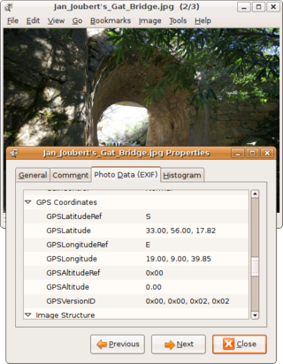
Geotagging, or GeoTagging, is the process of adding geographical identification metadata to various media such as a geotagged photograph or video, websites, SMS messages, QR Codes or RSS feeds and is a form of geospatial metadata. This data usually consists of latitude and longitude coordinates, though they can also include altitude, bearing, distance, accuracy data, and place names, and perhaps a time stamp.
The Extensible Metadata Platform (XMP) is an ISO standard, originally created by Adobe Systems Inc., for the creation, processing and interchange of standardized and custom metadata for digital documents and data sets.
A camera raw image file contains unprocessed or minimally processed data from the image sensor of either a digital camera, a motion picture film scanner, or other image scanner. Raw files are so named because they are not yet processed, and contain large amounts of potentially redundant data. Normally, the image is processed by a raw converter, in a wide-gamut internal color space where precise adjustments can be made before conversion to a viewable file format such as JPEG or PNG for storage, printing, or further manipulation. There are dozens of raw formats in use by different manufacturers of digital image capture equipment.

Since the Global Positioning System (GPS) was introduced in the late 1980s there have been many attempts to integrate it into a navigation-assistance system for blind and visually impaired people.

A point of interest (POI) is a specific point location that someone may find useful or interesting. An example is a point on the Earth representing the location of the Eiffel Tower, or a point on Mars representing the location of its highest mountain, Olympus Mons. Most consumers use the term when referring to hotels, campsites, fuel stations or any other categories used in modern automotive navigation systems.
Geo is a microformat used for marking up geographical coordinates in HTML. Coordinates are expected in angular units of degrees and geodetic datum WGS84. Although termed a "draft" specification, the format is a de facto standard, stable and in widespread use; not least as a sub-set of the published hCalendar and hCard microformat specifications, neither of which is still a draft.
FastPictureViewer is a freemium image viewer for Windows XP and later. Its aim is to facilitate quick review, rating and annotation of large quantities of digital images in the early steps of the digital workflow, with an emphasis on simplicity and speed. As an app with a freemium license, a basic version is available cost-free for personal, non-profit or educational uses, while a commercial license is required for the professional version with additional features. The basic version starts as a full version trial.
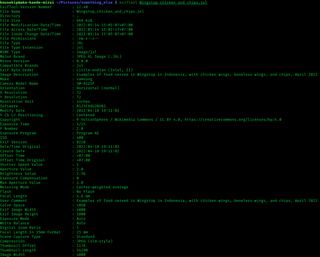
ExifTool is a free and open-source software program for reading, writing, and manipulating image, audio, video, and PDF metadata. It is platform independent, available as both a Perl library (Image::ExifTool) and command-line application. ExifTool is commonly incorporated into different types of digital workflows and supports many types of metadata including Exif, IPTC, XMP, JFIF, GeoTIFF, ICC Profile, Photoshop IRB, FlashPix, AFCP and ID3, as well as the manufacturer-specific metadata formats of many digital cameras.

A satellite navigation device, satnav device or satellite navigation receiver is a user equipment that uses one or more of several global navigation satellite systems (GNSS) to calculate the device's geographical position and provide navigational advice. Depending on the software used, the satnav device may display the position on a map, as geographic coordinates, or may offer routing directions.
Sidecar files, also known as buddy files or connected files, are computer files that store data which is not supported by the format of a source file.
GeoSmart (NZ) Ltd is a provider of location-based services, digital mapping data and images for the Oceania area, notably New Zealand. The company is one of only a handful of global companies producing digital maps for use in GPS applications. GeoSmart was acquired by TomTom in 2014.
The Ricoh 500SE digital compact camera is suitable for outdoor photography and networkability. Capability includes external information such as GPS position or barcode numbers within the image headers. External vendors sell hardware and software for workflows involving GPS positioning or barcode scanning. Most NMEA compliant bluetooth GPS receivers can be used with this camera through its built in bluetooth communication capability. The body is resistant to dust and water, making it robust for many environments.

TeleType Co., Inc. is a privately held company in the United States, specialized in developing software for GPS devices. It was founded in 1981, under the name TeleTypesetting Company and it is based in Boston, Massachusetts. The company's product line includes automotive and commercial GPS navigation systems and other products including GPS receivers and tracking units. It develops and sells the WorldNav software for PC and Windows CE, tools for converting third party maps into WorldNav maps, an SDK and an API that allow the customization of the WorldNav application. TeleType Co. also offers consultancy services for those interested in acquiring and adapting the source code of their software products.
ITN, is a file format designed as an itinerary data format for TomTom devices.