
The Hopi are Native Americans who primarily live in northeastern Arizona. The majority are enrolled in the Hopi Tribe of Arizona and live on the Hopi Reservation in northeastern Arizona; however, some Hopi people are enrolled in the Colorado River Indian Tribes of the Colorado River Indian Reservation at the border of Arizona and California.
Aztec is a city in, and the county seat of, San Juan County, New Mexico, United States. The city population was 6,126 as of the 2022 population estimate. The Aztec Ruins National Monument is located in Aztec.

Navajo or Navaho is a Southern Athabaskan language of the Na-Dené family, through which it is related to languages spoken across the western areas of North America. Navajo is spoken primarily in the Southwestern United States, especially in the Navajo Nation. It is one of the most widely spoken Native American languages and is most widely spoken north of the Mexico–United States border, with almost 170,000 Americans speaking Navajo at home as of 2011.

The Southwestern United States, also known as the American Southwest or simply the Southwest, is a geographic and cultural region of the United States that includes Arizona and New Mexico, along with adjacent portions of California, Colorado, Nevada, Oklahoma, Texas, and Utah. The largest cities by metropolitan area are Phoenix, Las Vegas, El Paso, Albuquerque, and Tucson. Before 1848, in the historical region of Santa Fe de Nuevo México as well as parts of Alta California and Coahuila y Tejas, settlement was almost non-existent outside of Nuevo México's Pueblos and Spanish or Mexican municipalities. Much of the area had been a part of New Spain and Mexico until the United States acquired the area through the Treaty of Guadalupe Hidalgo in 1848 and the smaller Gadsden Purchase in 1854.

The Four Corners is a region of the Southwestern United States consisting of the southwestern corner of Colorado, southeastern corner of Utah, northeastern corner of Arizona, and northwestern corner of New Mexico. Most of the Four Corners region belongs to semi-autonomous Native American nations, the largest of which is the Navajo Nation, followed by Hopi, Ute, and Zuni tribal reserves and nations. The Four Corners region is part of a larger region known as the Colorado Plateau and is mostly rural, rugged, and arid.

U.S. Route 491 (US 491) is a north–south U.S. Highway serving the Four Corners region of the United States. It was created in 2003 as a renumbering of U.S. Route 666 (US 666). With the US 666 designation, the road was nicknamed the "Devil's Highway" because of the significance of the number 666 to many Christian denominations as the Number of the Beast. This Satanic connotation, combined with a high fatality rate along the New Mexico portion, convinced some people the highway was cursed. The problem was compounded by persistent sign theft. These factors led to two efforts to renumber the highway, first by officials in Arizona, then by those in New Mexico. There have been safety improvement projects in recent years, and fatality rates have subsequently decreased.
The term Navajo Wars covers at least three distinct periods of conflict in the American West: the Navajo against the Spanish ; the Navajo against the Mexican government ; and the Navajo against the United States. These conflicts ranged from small-scale raiding to large expeditions mounted by governments into territory controlled by the Navajo. The Navajo Wars also encompass the widespread raiding that took place throughout the period; the Navajo raided other tribes and nearby settlements, who in return raided into Navajo territory, creating a cycle of raiding that perpetuated the conflict.
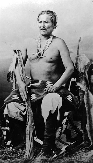
The Navajo are a Native American people of the Southwestern United States.

To’Hajiilee, Cañoncito Band of Navajos is a non-contiguous section of the Navajo Nation lying in parts of western Bernalillo, eastern Cibola, and southwestern Sandoval counties in the U.S. state of New Mexico, west of the city of Albuquerque. It is a Navajo phrase roughly translated in English as "Dipping Water."

The Navajo Livestock Reduction was imposed by the United States government upon the Navajo Nation in the 1930s, during the Great Depression. The reduction of herds was justified by the government by stating that grazing areas were becoming eroded and had deteriorated due to too many animals.
The Navajo meridian, established in 1869, is one of the two principal meridians for Arizona, the other being the Gila and Salt River meridian. Its initial point was stated as latitude 35° 45' north, longitude 108° 32' 45" west from Greenwich, but has been revised as 35°44′56″N108°31′59″W The Navajo meridian and baseline were used to set townships and ranges in a special survey for the original Navajo Reservation, and was set at the eastern boundary of that reservation. The Arizona lands surveyed using the Navajo meridian and baseline were ranges six west to ten west and townships one north to fourteen north, and included Canyon de Chelly National Monument.
The El Paso and Southwestern Railroad began in 1888 as the Arizona and South Eastern Railroad, a short line serving copper mines in southern Arizona. Over the next few decades, it grew into a 1200-mile system that stretched from Tucumcari, New Mexico, southward to El Paso, Texas, and westward to Tucson, Arizona, with several branch lines, including one to Nacozari, Mexico. The railroad was bought by the Southern Pacific Railroad in 1924 and fully merged into its parent company in 1955. The EP&SW was a major link in the transcontinental route of the Golden State Limited.
Jeff King was a US Army scout from 1891 to 1911, and went on to become a highly respected hataałii.

Washington Matthews was a surgeon in the United States Army, ethnographer, and linguist known for his studies of Native American peoples, especially the Navajo.
Williams v. Lee, 358 U.S. 217 (1959), was a landmark case in which the Supreme Court of the United States held that the State of Arizona does not have jurisdiction to try a civil case between a non-Indian doing business on a reservation with tribal members who reside on the reservation, the proper forum for such cases being the tribal court.
See also Zuni ethnobotany, and Native American ethnobotany.

The Indigenous peoples of the North American Southwest are those in the current states of Colorado, Arizona, New Mexico, Utah, and Nevada in the western United States, and the states of Sonora and Chihuahua in northern Mexico. An often quoted statement from Erik Reed (1666) defined the Greater Southwest culture area as extending north to south from Durango, Mexico to Durango, Colorado and east to west from Las Vegas, Nevada to Las Vegas, New Mexico. Other names sometimes used to define the region include "American Southwest", "Northern Mexico", "Chichimeca", and "Oasisamerica/Aridoamerica". This region has long been occupied by hunter-gatherers and agricultural people.
Claudeen Bates Arthur was a Native American lawyer who was the first Navajo woman licensed as a lawyer in the United States and the first female Chief Justice of the Supreme Court of the Navajo Nation.

Louisa Wade Wetherill lived with her husband and children in remote trading posts among the Navajo people in New Mexico, Utah, and Arizona for more than 25 years and became an authority on Navajo culture. She spoke the Navajo language and became expert in medicinal herbs and plants known to the Navajo, art, especially sandpainting, traditional stories, and weaving. She was known by the Navajo as Asthon Sosi or "Slim Woman."
William Morgan was a Navajo linguist and translator. He is best known for his work with Robert W. Young, who he collaborated with on a series of books that documented the Navajo language. He also coauthored several other books about Navajo language, culture, and history with Leon Wall and Edward Mays. He and Young started the publication of Ádahooníłígíí, a bilingual Navajo-English newspaper. He received an honorary degree from the University of New Mexico.