Naval Facility Nantucket

Last updated
Naval Facility (NAVFAC) Nantucket
Siasconset, Nantucket, Massachusetts
NAVFAC Nantuckett early 1960s.jpg
NAVFAC Nantuckett ca. early 1960s after replacement of most Quonset buildings. Terminal building close to beach (center) in its own compound.
Coordinates 41°14′28.31″N70°0′25.32″W / 41.2411972°N 70.0070333°W / 41.2411972; -70.0070333
Type SOSUS shore terminus
Site information
Controlled byCommander, Oceanographic System Atlantic (COMOCEANSYSLANT)
Open to
the public
No (mission and purpose classified until 1991)
Site history
Built1954-1955
Built byUnited States Navy
In use1955-1976
Garrison information
Occupants
  • 8 officers, 89 enlisted
  • 10 officers, 94 enlisted by 1962

Naval Facility Nantucket Island or simply Naval Facility Nantucket (NAVFAC Nantucket) was a shore terminal of the Sound Surveillance System (SOSUS) active from 1955 to 1976. The true function of the system and the shore terminals, in which output of the array at sea was processed and displayed by means of the Low Frequency Analyzer and Recorder (LOFAR), was classified and the term "Naval Facility" was intentionally vague. Its function was described as oceanographic research.

Contents

The facility was built about twelve miles from the town of Nantucket on a part of a site that had been used in World War II as an ordinance site and practice bombing range. Locally the facility was sometimes known as the Tom Nevers Naval Facility for the area of Nantucket island where it stood. [note 1]

In 1980 the property was sold to the Town of Nantucket and is now a park managed by the Parks and Recreation Commission.

History

Naval Facility (NAVFAC) Nantucket was among the first Atlantic systems ordered and installed with the shore facility commissioned 1 August 1955. [1] [2] The facility, along with the entire Atlantic system at the time, was experimental though it quickly became operational. [3] The visible shore installations and obvious cable work done in connection with their construction required a cover story explaining them as oceanographic research facilities and that data gathered by oceanographic and acoustic surveys with ships could at times be collected "more expeditiously and more economically by means of shore stations. These are the U. S. Naval Facilities." [4] The "oceanographic" cover included the entire span of the facility's existence and decommissioning on 30 June 1976 with the SOSUS mission being declassified in 1991. [2]

The site, about twelve miles from the town of Nantucket on Tom Never’s Head at the southernmost tip of the island, had been part of the Nantucket Ordnance Site. [1] [5] During World War II the land had been leased by the government from September 1943 through 30 June 1946 for use as the Nantucket Ordnance Site (also known as Tom Nevers Rocket Projectile Target) used for as an aerial rocket range by pilots from the Quonset Naval Air Station. [6]

Lofargram writers on watch floor. Watch floor.gif
Lofargram writers on watch floor.

In 1958 the facility was still in Quonset huts housing both the sensitive electronic equipment and eight officers and eighty-nine enlisted men. Within five years the temporary buildings had deteriorated putting the terminal building electronics at risk. The complement had grown to ten officers and ninety-four enlisted men and new combination administration building and barracks was requested along with a mess hall and recreation facilities. [3] [7] It was evident that the classified details of the system and its shore terminal was not clear even to some high ranking Senators as the same request for replacement buildings was met by questions in the Senate Committee as to why it could not be moved to another location, including the Boston Navy Yard, and why its "oceanographic work" could not be done at Woods Hole. [8] The Navy again requested funds in 1964 to upgrade facilities to permanent buildings. [9] Fourteen units of family housing were authorized in 1967. [10]

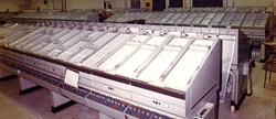
The surveillance system shore processing facilities underwent backfits during the late 1960s at the stations replacing original equipment with more modern equipment including moving from electromechanical spectrum analysis to digital. [11]

A bomb shelter for President John F. Kennedy, to be used in the event of a nuclear attack while President Kennedy was in Hyannisport, was located under a mound built on the facility. [5]

The first decommissioning of SOSUS shore stations came in 1976 when the first to be commissioned, Naval Facility Punta Borinquen (commissioned 18 September 1954 as NAVFAC Ramey), Puerto Rico, was closed on 30 April followed by Naval Facility Nantucket on 30 June. [1] [2] [12]

Return to civilian use

The Town of Nantucket purchased the property from the Navy in 1980 for US$525,000(equivalent to $1,649,000 in 2020) with the intent it would be used as a recreation area. The approximately twenty-five acres included over 1,000 ft (304.8 m) of shoreline. Fifteen acres were transferred to the Nantucket Housing Authority and the Veterans of Foreign Wars (VFW) leased the recreation building and some three adjacent acres on which they sponsor an annual beach carnival. Many of the Navy buildings and some of the paved roads had been removed after decommissioning of the Naval Facility and the remaining stripped buildings were in poor condition. The Terminal Building was close to collapse onto the beach due to erosion and the VFW building was only 80 ft (24.4 m) from the point of erosion on the coastal bank. [13]

The Nantucket Parks and Recreation Commission managed the property with the VFW managing its portion and holding public events there. [13] The Nantucket Hunting Association obtained permission to use the bunker in 1995 but it was later used by Parks and Recreation as storage. By 2018 there was interest in restoring the bunker as a museum and attraction and there was some interest in obtaining objects that had been used in the West Palm Beach Kennedy bunker, which had closed, and associating with former management of that site. [5] [13] [14]

As of 2020 the Town and County of Nantucket shows the Tom Nevers Park owned and managed by the Parks and Recreation Commission. [15]

Erosion

Beach erosion was a problem, clearly by 1969 and by closure was threatening the Terminal Building containing all the equipment. After closure the Terminal Building was in danger of toppling onto the beach and was eventually demolished. [16] [13]

Footnotes

  1. This was apparently the local name, predating the establishment of the SOSUS Naval Facility, applied to the leased ordnance site that was officially the Nantucket Ordnance Site.

See also

Related Research Articles

SOSUS Cold war passive, fixed array undersea surveillance system.

The Sound Surveillance System (SOSUS) was a passive sonar system developed by the United States Navy to track Soviet submarines. The system's true nature was classified with the name and acronym SOSUS themselves classified. The unclassified name Project Caesar was used to cover the installation of the system and a cover story developed regarding the shore stations, identified only as a Naval Facility (NAVFAC), being for oceanographic research. In 1985, as the fixed bottom arrays were supplemented by the mobile Surveillance Towed Array Sensor System (SURTASS) and other new systems were coming on line, the name itself changed to Integrated Undersea Surveillance System (IUSS). The commands and personnel were covered by the "oceanographic" term until 1991 when the mission was declassified. As a result, the commands, Oceanographic System Atlantic and Oceanographic System Pacific became Undersea Surveillance Atlantic and Undersea Surveillance Pacific, and personnel were able to wear insignia reflecting the mission.

Grand Turk Island

Grand Turk Island is an island in the Turks and Caicos Islands. It is the largest island in the Turks Islands with 18 km2 (6.9 sq mi). Grand Turk contains the territory's capital, Cockburn Town, and the JAGS McCartney International Airport. The island is the administrative, historic, cultural and financial center of the territory and has the second-largest population of the islands at approximately 4,831 people in 2012.

Eleuthera Island in the Bahamas

Eleuthera refers both to a single island in the archipelagic state of The Commonwealth of the Bahamas and to its associated group of smaller islands. Eleuthera forms a part of the Great Bahama Bank. The island of Eleuthera incorporates the smaller Harbour Island. "Eleuthera" derives from the feminine form of the Greek adjective ἐλεύθερος (eleútheros), meaning "free". Known in the 17th century as Cigateo, it lies 80 km east of Nassau. It is long and thin—180 km long and in places little more than 1.6 km wide. Its eastern side faces the Atlantic Ocean, and its western side faces the Great Bahama Bank. The topography of the island varies from wide rolling pink sand beaches to large outcrops of ancient coral reefs, and its population is approximately 11,000. The principal economy of the island is tourism.

SOFAR channel A horizontal layer of water in the ocean at which depth the speed of sound is at its minimum

The SOFAR channel, or deep sound channel (DSC), is a horizontal layer of water in the ocean at which depth the speed of sound is at its minimum. The SOFAR channel acts as a waveguide for sound, and low frequency sound waves within the channel may travel thousands of miles before dissipating. An example was reception of coded signals generated by the Navy chartered ocean surveillance vessel Cory Chouest off Heard Island, located in the southern Indian Ocean, by hydrophones in portions of all five major ocean basins and as distant as the North Atlantic and North Pacific.

Saint Lucy, Barbados Parish in Barbados

The parish of Saint Lucy is the northernmost area in the country of Barbados. Saint Lucy is the only parish of Barbados out of the eleven to be named after a female patron saint, Saint Lucy of Syracuse. Saint Lucy's shape also resembles a peninsula, surrounded on three sides by the Atlantic Ocean to the north, east and west. The Harrison Point Lighthouse is located in Harrisons, Saint Lucy between Great Head and Norse's Bay, also in Saint Lucy. To the south lies the neighbouring Parish of Saint Peter.

Fort Miles

Fort Miles was a United States Army World War II installation located on Cape Henlopen near Lewes, Delaware. Although funds to build the fort were approved in 1934, it was 1938 before construction began on the fort. On 3 June 1941 it was named for Lieutenant General Nelson A. Miles.

Naval Station Argentia Former US Navy base

Naval Station Argentia is a former base of the United States Navy that operated from 1941 to 1994. It was established in the community of Argentia in what was then the Dominion of Newfoundland, which later became the tenth Canadian province, Newfoundland and Labrador.

RAF Brawdy

RAF Brawdy is a former Royal Air Force satellite station located 6.3 miles (10.1 km) east of St Davids, Pembrokeshire and 9.8 miles (15.8 km) south west of Fishguard, Pembrokeshire, Wales. It was operational between 1944 and 1992 being used by both the Royal Air Force and the Royal Navy before the site was turned over to the British Army and renamed Cawdor Barracks.

Ramey Air Force Base Former United States Air Force base in Aguadilla, Puerto Rico

Ramey Air Force Base is a former United States Air Force base in Aguadilla, Puerto Rico. It was named after United States Army Air Forces Brigadier General Howard Knox Ramey. Following its closure, it was redeveloped into Rafael Hernandez Airport.

Naval Facility Bermuda

Naval Facility Bermuda, or NAVFAC Bermuda, was the operational shore terminus for one of the Atlantic Sound Surveillance System (SOSUS) array systems installed during the first phase of system installation and in commission from 1955 until 1992. The true surveillance mission was classified and covered by "oceanographic research" until the mission was declassified in 1991. The system's acoustic data was collected after the facility was decommissioned until the system was routed to the central processing facility, the Naval Ocean Processing Facility (NOPF), Dam Neck, Virginia in 1994.

USNS <i>Neptune</i>

USNS Neptune (ARC-2), was the lead ship in her class of cable repair ships in U.S. Naval service. The ship was built by Pusey & Jones Corp. of Wilmington, Delaware, Hull Number 1108, as the USACS William H. G. Bullard named for Rear Adm. William H. G. Bullard. She was the first of two Maritime Commission type S3-S2-BP1 ships built for the US Army Signal Corps near the end of World War II. The other ship was the Albert J. Myer, which later joined her sister ship in naval service as the USNS Albert J. Myer (T-ARC-6). The ship was built by Pusey & Jones Corp. of Wilmington, Delaware as Hull Number 1108.

USS <i>Aeolus</i> (ARC-3) Attack cargo ship converted into a cable repair ship

USS Aeolus (ARC-3) began service as USS Turandot (AKA-47), an Artemis-class attack cargo ship built by the Walsh-Kaiser Co., Inc. of Providence, Rhode Island. In 1954 she was converted into a cable repair ship to support Project Caesar, the unclassified name for installation of the Sound Surveillance System SOSUS. Aeolus was the first of two ships, the other being USS Thor (ARC-4), to be converted into cable ships. Aeolus performed cable duties for nearly thirty years, from 1955 to 1973 as a commissioned ship and from 1973 until 1985 as the civilian crewed USNS Aeolus (T-ARC=3) of the Military Sealift Command (MSC). The ship was retired in 1985 and sunk as an artificial reef in 1988.

United States Naval Facility, Barbados

Naval Facility (NAVFAC) Barbados, TWI, in commission 1957 to 1979, was the most southern of the Atlantic Sound Surveillance System (SOSUS) shore terminals. It had the distinction making the first system detection of a Soviet nuclear submarine in 1962 as that submarine was transiting off Norway. The facility was located adjacent to the Harrison Point Lighthouse, Parish of Saint Lucy.

CFS Shelburne

Canadian Forces Station (CFS) Shelburne is a former Canadian Forces Station that was a shore terminus for the Sound Surveillance System (SOSUS) from 1955 to 1994. It was located in the Municipality of the District of Shelburne, Shelburne County, Nova Scotia.

Naval Air Facility Midway Island US air station in the Midway Atoll

Naval Air Station Midway Island, also known as NAS Midway, Naval Air Facility Midway, and NAF Midway, was a U.S. Naval Air Station in the Midway Atoll, the northernmost group of the Hawaiian archipelago. It was in operation from 1941 to 1993, and played an important role in trans-Pacific aviation during those years. Through its lifetime, the facility was variously designated as a Naval Air Station, a Naval Air Facility, and a naval base. It was finally closed on 1 October 1993.

Argus Island

Argus Island was an acoustic research tower and platform located on Plantagenet Bank, a guyot about 30 miles southwest of the island of Bermuda. The tower was originally part of the facilities supporting Project Artemis and Project Trident under auspices of the Tudor Hill Laboratory, a facility of the US Navy's Underwater Sound Laboratory. Later the tower was used for additional acoustic experiments as well as oceanographic observations, wave height measurements, optical observations, air containment measurements and measurements of the effects of the ocean environment on the structure itself.

Naval Facility Cape Hatteras

Naval Facility Cape Hatteras was a Sound Surveillance System (SOSUS) shore terminal, one of the nine initial systems installed, located on Cape Hatteras near Buxton, North Carolina and adjacent to the old location of the Cape Hatteras lighthouse. NAVFAC Cape Hatteras, eighth of the initial nine Atlantic systems to be activated, was in commission 11 January 1956 to 30 June 1982.

Naval Facility Point Sur Military unit

Naval Facility Point Sur was one of 30 secret sites worldwide that were built during the Cold War to detect Soviet submarines. In 1958, the U.S. Navy built a Naval Facility (NAVFAC) ½ mile south of Point Sur on the Big Sur coast to provide submarine surveillance using the classified SOund SUrveillance System (SOSUS). The public was told the station was engaged in oceanographic research.

Naval Facility Centerville Beach

In 1958 Naval Facility (NAVFAC) Centerville Beach was the third Sound Surveillance System (SOSUS) shore terminal, in which output of the array at sea was processed and displayed by means of the Low Frequency Analyzer and Recorder (LOFAR), established on the Pacific coast. The previous year the last of the original Atlantic systems, Naval Facility Barbados, had become operational and the first of the Pacific systems had been installed at San Nicolas Island. Naval Facility Point Sur to the south had been commissioned on 8 January 1958. The SOSUS mission, as well as the name itself was classified until 1991. The facility was installed under the cover name Project Caesar and described as being engaged in "oceanographic research" with its actual role in undersea surveillance not revealed until two years before the facility closed.

Two closely related terms, Low Frequency Analyzer and Recorder and Low Frequency Analysis and Recording bearing the acronym LOFAR, deal with the equipment and process respectively for presenting a visual spectrum representation of low frequency sounds in a time–frequency analysis. The process was originally applied to fixed surveillance passive antisubmarine sonar systems and later to sonobuoy and other systems. Originally the analysis was electromechanical and the display was produced on electrostatic recording paper, a Lofargram, with stronger frequencies presented as lines against background noise. The analysis migrated to digital and both analysis and display were digital after a major system consolidation into centralized processing centers during the 1990s.

References

  1. 1 2 3 Commander, Undersea Surveillance. "Naval Facility Nantucket August 1955 - June 1976". U.S. Navy. Retrieved 17 February 2020.
  2. 1 2 3 "Integrated Undersea Surveillance System (IUSS) History 1950 - 2010". IUSS/CAESAR Alumni Association. Retrieved 11 February 2020.
  3. 1 2 Hearings Before (House) Armed Services Committee (Report). Washington, D.C.: U.S. Government Printing Office. 1962. pp. 159–161. Retrieved 27 February 2020.
  4. "SOSUS Unclassified Cover Story". IUSS/CAESAR Alumni Association. Retrieved 11 February 2020.
  5. 1 2 3 Jenness, Amy (August 27, 2015). "JFK Sailed to Island, Never Came Ashore". Yesterday's Island, Today's Nantucket. Retrieved 17 February 2020.
  6. ERT, Inc. (for USACE Corps of Engineers, New England District) (July 2018). Land Use Control and Long-Term Management Implementation Plan for Nantucket Beach Formerly Used Defense Site Project No. D01MA045601 Nantucket Island, Massachusetts (Report). Retrieved 17 February 2020.CS1 maint: multiple names: authors list (link)
  7. Hearings on Military Construction Authorization 1958 (Report). Washington, D.C.: U.S. Government Printing Office. 1958. pp. 424–425. Retrieved 27 February 2020.
  8. Hearings Before Committee (Senate) on Armed Services (Report). Washington, D.C.: U.S. Government Printing Office. 1962. pp. 241–243. Retrieved 27 February 2020.
  9. Hearings on Military Construction Authorization 1965 (Report). Washington, D.C.: U.S. Government Printing Office. 1965. p. 212. Retrieved 17 February 2020.
  10. Public Law 90-110 (PDF) (Report). U.S. Government Printing Office. October 21, 1967. p. 303. Retrieved 17 February 2020.
  11. Weinel, Jim (Spring 2003). "Evolution of SOSUS/IUSS Signal Processing (Part 1 of 2)" (PDF). The Cable. Vol. 6 no. 1. IUSS/CAESAR Alumni Association. p. 3. Retrieved 11 February 2020.
  12. Commander, Undersea Surveillance. "Naval Facility Ramey September 1954 - April 1976". U.S. Navy. Retrieved 27 February 2020.
  13. 1 2 3 4 Re-use Plan for Tom Nevers Former Navy Base Site (Report). Nantucket, MA: Nantucket Planning & Economic Development Commission. July 6, 1995. Retrieved 27 February 2010.
  14. Sutters, Peter (May 7, 2018). "Nantucket nuclear bunker could be new Kennedy museum". South Coast Today. Retrieved 27 February 2020.
  15. "Beaches & Parks". Town & County of Nantucket, MA. 2020. Retrieved 27 February 2020.
  16. Naval History And Heritage Command (March 1969). "Collection photo # 2017.40.01 - aerial view of Naval Facility Nantucket, MA". Naval History And Heritage Command. Retrieved 27 February 2010.