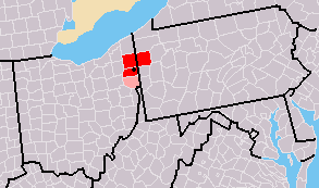
Mahoning County is a county in the U.S. state of Ohio. As of the 2020 census, the population was 228,614. Its county seat and largest city is Youngstown. The county is named after the Mahoning River and was formed on March 1, 1846; the 83rd county in Ohio. Until 1846, the area that is now Mahoning County was part of Trumbull and Columbiana counties, when the counties in the area were redefined and Mahoning County emerged as a new county. Mahoning County is part of the Youngstown–Warren, OH Metropolitan Statistical Area.

Boardman Township is one of the fourteen townships of Mahoning County, Ohio, United States. The population was 40,213 at the 2020 census. A suburb directly south of Youngstown, it is the second largest municipality in the Youngstown–Warren metropolitan area and is a major retail hub for the region.

Campbell is a city in eastern Mahoning County, Ohio, United States, along the Mahoning River. The population was 7,852 at the 2020 census. Located directly southeast of Youngstown, it is a suburb of the Youngstown–Warren metropolitan area.

Struthers is a city in eastern Mahoning County, Ohio, United States, along the Mahoning River. The population was 10,063 at the 2020 census. Located directly southeast of Youngstown, it is a suburb of the Youngstown–Warren metropolitan area.

Youngstown is a city in and county seat of Mahoning County, Ohio, United States. At the 2020 census, it had a population of 60,068, making it the 11th-most populous city in Ohio. It is a principal city of the Youngstown–Warren metropolitan area, which had a population of 430,591 in 2020, making it the seventh-largest metro area in Ohio and 125th-largest metro area in the U.S. Youngstown is situated on the Mahoning River in Northeast Ohio, 58 miles (93 km) southeast of Cleveland and 61 miles (100 km) northwest of Pittsburgh.

The Mahoning River is a river in northeastern Ohio and a small portion of western Pennsylvania. Flowing primarily through several Ohio counties, it crosses the state line into Pennsylvania before joining with the Shenango River to form the Beaver River. The Mahoning River drops from 1,296 feet (395 m) at the headwaters near Winona to 761 feet (232 m) at the outfall near Mahoningtown, Pennsylvania. It is part of the Ohio River watershed. The name is said to derive from either the Lenape or Shawnee languages and mean "Deer Lick," as the area was once known for salt springs, but it's possible the name of the Mahoning and several other similarly named landmarks and places in western Pennsylvania could come from the Lenape, mënehokink (may-nuh-ho-keeng), meaning "place to get water."
Lansingville is a neighborhood in Youngstown, Ohio. Located on the city's south side, the area was named for John Lansing. The neighborhood was dominated by Slovak Americans, the majority of whom were Roman Catholic, during much of the 20th century.

The Mahoning Valley is a geographic valley encompassing Northeast Ohio and a small portion of Western Pennsylvania that drains into the Mahoning River. According to information at the bottom of Page 321 in a publication by the Ohio Secretary of State's Office, the river name comes from an Indian word meaning “at the licks.”
Brier Hill is a neighborhood in Youngstown, Ohio, that was once viewed as the city's "Little Italy." The neighborhood, which was the site of the city's first Italian settlement, stretches along the western edge of Youngstown's lower north side and encircles St. Anthony's Church, an Italian-American Roman Catholic parish. Each year, at the end of August, the Brier Hill Fest attracts thousands of visitors from Northeast Ohio and Western Pennsylvania.
Smoky Hollow is a neighborhood in Youngstown, Ohio. Located northeast of Youngstown's downtown, Smoky Hollow is now part of the campus of Youngstown State University. The district has long been in a state of decline, but plans are now underway to transform Smoky Hollow into a large field built to serve the University.

Hazelton is a neighborhood in Youngstown, Ohio, located on the city's east side. It is bordered by the cities of Struthers and Campbell. In the early 20th century, the neighborhood was alternately referred to as "the East End".
Fosterville is a neighborhood in Youngstown, Ohio, that is located on the south-southwestern side of the city. In the course of a recent revitalization effort, called "Youngstown 2010", the original Fosterville neighborhood has been subdivided into two distinct neighborhood areas: Idora and Warren.

Mill Creek Park is a metropolitan park located in Youngstown, Ohio. It stretches from the near west side of Youngstown to the southern borders of the city and neighboring Boardman, Ohio. The park "encompasses approximately 4400 acres (10.5 km²), 20 mi (32 km) of drives, and 15 mi (24 km) of foot trails" as well as a variety of bridges, ponds, streams, well-tended gardens, and waterfalls. The Trust for Public Land ranks one part of Mill Creek as the 142nd largest park located within the limits of a U.S. city.

The Youngstown–Warren, OH Metropolitan Statistical Area, typically known as the Mahoning Valley, is a metropolitan area in Northeast Ohio with Youngstown, Ohio, at its center. According to the U.S. Census Bureau, the metropolitan statistical area (MSA) includes Mahoning and Trumbull counties. As of the 2020 census, the region had a population of 430,591, making it the 125th-largest metro area in the country.

Vienna Township is one of the twenty-four townships of Trumbull County, Ohio, United States. The 2020 census enumerated 3,978 people in the township.

The economy of Youngstown, Ohio, United States, flourished in the 19th and early 20th centuries, with steel production reaching all-time highs at that time. The steel boom led to an influx of immigrants to the area looking for work, as well as construction of skyscrapers in the area. The city's population peaked at 170,002 in 1930, just at the onset of the Great Depression. World War II also brought a great demand for steel. After World War II, demand for steel dropped off dramatically, and industrial base of Youngstown began to see a decline.

Brownlee Woods is a neighborhood in Youngstown, Ohio. The neighborhood is bordered by Struthers to the east, Interstate 680 to the west, Boardman to the south, and Midlothian Blvd to the north.
The Coal miners' strike of 1873, was a strike against wage cuts in the Mahoning, Shenango, and TuscarawasValleys of northeastern Ohio and northwestern Pennsylvania. In the Tuscarawas Valley, the labor action lasted six months, and in the Mahoning Valley four and a half months, but the walkouts failed. The introduction of imported strikebreakers and manufacturers finding substitutes for the area's special block-coal, forced the organized miners back to work at prevailing wages.
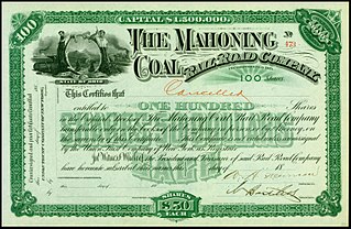
The Mahoning Coal Railroad (MCR) was a railroad line in the U.S. states of Ohio and Pennsylvania. Incorporated in 1871, it largely linked Youngstown, Ohio, with Andover, Ohio. It had a major branch into Sharon, Pennsylvania, and several small branches and spurs to coal mines and iron works along the Ohio-Pennsylvania border. The railroad leased itself to the Lake Shore and Michigan Southern Railway in 1873. The lease was assumed by the New York Central Railroad in 1914, when that company consolidated with the Lake Shore & Michigan Southern. The New York Central merged with the Pennsylvania Railroad in 1968 to create the Penn Central. Despite abandonment of much track, bankruptcy of the Penn Central in 1970 eventually caused the MCR's dissolution on January 7, 1982.
Schenley (/ˈʃεnli/) is a neighborhood on the West Side of Youngstown, Ohio, United States. It is bordered by Belle Vista to the north, Mahoning Commons to the northeast, Oak Hill to the east, Warren to the southeast, Idora to the south, Kirkmere to the south, southwest, and west, and Austintown to the northwest.

