
Visakhapatnam, also known as Vizag, Viśākha or Waltair, is the largest and most populous metropolitan city in the Indian state of Andhra Pradesh. It is between the Eastern Ghats and the coast of the Bay of Bengal. It is the second largest city on the east coast of India after Chennai, and the fourth-largest in South India. It is one of the four smart cities of Andhra Pradesh selected under the Smart Cities Mission and is the headquarters of Visakhapatnam district. With an estimated output of $43.5 billion, it is the ninth-largest contributor to India's gross domestic product as of 2016.
Amaravathi is a village on the banks of the Krishna River, in the Palnadu district of the Indian state of Andhra Pradesh. It is the headquarters of Amaravathi mandal, and forms part of the Andhra Pradesh Capital Region with its headquarters at new Amaravati 35 km (22 mi) east, whose name is also borrowed from that of the older Amaravathi.

Vizianagaram district is one of the six districts in the Uttarandhra region of the Indian state of Andhra Pradesh with its headquarters located at Vizianagaram. The district was once the part of ancient Kalinga.Saripilli Dibbilingeswara temple, Jayathi Mallikarjuna Temple are the finest examples of ancient Eastern Ganga Dynasty built monuments in the district. The district is bounded on the east by the district of Srikakulam, north by Parvathipuram Manyam south by Visakhapatnam, Anakapalli, southeast by the Bay of Bengal, and west by Alluri Sitharama Raju district. It was formed on 1 June 1979, with some parts carved from the neighbouring districts of Srikakulam and Visakhapatnam. The district is named after the princely state of Vizianagaram. In 2011, it was the least populous district in Andhra Pradesh.

Guntur district is one of the twenty six districts in the Coastal Andhra region of the Indian state of Andhra Pradesh. The administrative seat of the district is located at Guntur, the largest city of the district in terms of area and with a population of 670,073. It has a coastline of approximately 100 km (62 mi) on the right bank of Krishna River, that separates it from Krishna district and NTR district. It is bounded on the south by Bapatla district and on the west by Palnadu district. It has an area of 2,443 km2 (943 sq mi) and with a population of 20,91,075 as per 2011 census of India.
Medak district is in the Indian state of Telangana. Medak is the district headquarters. The district shares boundaries with Sangareddy, Kamareddy, Siddipet and Medchal-Malkajgiri districts.

Dharanikota is a village in Palnadu district of the Indian state of Andhra Pradesh. It is located in Amaravathi mandal of Guntur revenue division. The village forms a part of Andhra Pradesh Capital Region, under the jurisdiction of APCRDA.

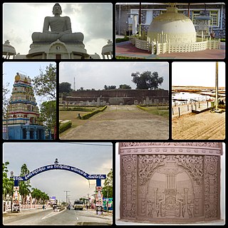
Bhattiprolu is a village in Bapatla district of the Indian state of Andhra Pradesh. It is the headquarters of Bhattiprolu mandal in Tenali revenue division. The Buddhist stupa in the village is one of the centrally protected monuments of national importance. One of the earliest evidence of Brahmi script in South India comes from Bhattiprolu. The script was written on an urn containing Buddha's relics. The script has been named Bhattiprolu script.

Bheemunipatnam, is a suburb of Visakhapatnam, India. The town was named after Bhima, a character in the Hindu epic Mahabharata. It formerly administered under the Bheemunipatnam municipality, but merged into GVMC in 2017. It is currently under the administration of Bheemunipatnam revenue division and the headquarters is located at Bheemunipatnam.

Tuni is a City in Kakinada district of the Indian state of Andhra Pradesh. It is a second biggest city in Kakinada district. Freedom fighter Alluri Sitaramaraju studied here. It is a major commercial marketing centre for more than 200+ surrounding villages in the district. Tuni is a border point for the district of Kakinada. It is known for mango production, with nearly 250 varieties being exported from the area. Tuni City is also known as "Mango City". Tuni is also famous for the production of betel leaves and jute bags. A variety of cashew nuts are also produced in Tuni.

The Gosthani river is a river in India. It rises in the Ananthagiri Hills of the Eastern Ghats and flows through the Borra Caves which lie near its source. It is the largest river flowing through Visakhapatnam city. It flows for 120 km before joining the Bay of Bengal through an estuary near Bheemunipatnam. The river basin drains the two coastal districts of Vizianagaram and Visakhapatnam. The basin exhibits a subdendritic and dendritic pattern of drainage. The Gosthani's is a minor river basin with a total drainage area of less than 2000 km2. Much of the basin is covered by khondalite group of gneissic rocks. About 3% of the total area of the Visakhapatnam district is under the Gosthani basin. The river is rainfed, receiving an average rainfall of 110 cm most of which comes from the south-west monsoon. There are several red sand hills near Bheemunipatnam, where the Gosthani joins the Bay of Bengal, which are reminiscent of the Chambal ravines. These are thought to have been formed six millennia ago due to shifts in the river's course following tectonic activity. The river joins the Bay of Bengal at Bhimli where it forms an estuary.
Chebrolu is a village in Guntur district of the Indian state of Andhra Pradesh. It is the headquarters of Chebrolu mandal in Tenali revenue division. It was once a Buddhist site and territorial capital of Kakatiya dynasty. The Archaeological excavations revealed Buddhist artefacts of Satavahana and Ikshavaku period.

Salihundam, is a village and panchayat in Gara Mandal of Srikakulam district in Andhra Pradesh. It is a historically important Buddhist monument of ancient Kalinga and a major tourist attraction It is a village lying on top of the hill on the south bank of the Vamsadhara River. It is at a distance of 5 KM west to Kalingapatnam and 10 KM from Singupuram and 18 KM from Srikakulam town. It was known as Salipetaka.
Lakkidam is a village and panchayat in Gantyada mandal of Vizianagaram district, Andhra Pradesh, India.
Bonangi is a village panchayat in Gantyada mandal of Vizianagaram district, Andhra Pradesh, India.

Buddam is a village in Guntur district of the Indian state of Andhra Pradesh. It is located in Karlapalem mandal of Tenali revenue division.
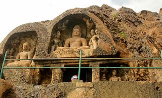
Bojjannakonda and Lingalakonda are two Buddhism rock-cut caves on adjacent hillocks, situated near a village called Sankaram, Anakapalle of ancient Kalinga. in the Indian state of Andhra Pradesh. The sites are believed to date between 4th and 9th Century A.D, when Buddhism is the majority religion of Sankaram. The original name of Bojjannakonda is Buddina Konda.

Kotturu Dhanadibbalu & Pandavula Guha is an ancient Buddhist site near Kotturu village of Rambilli mandal Visakhapatnam District of Andhra Pradesh. A post office is located at Kotturu Village with Pincode 531061

Gudiwada Dibba is a small hillock at Gudiwada village in Bhogapuram mandal, Vizianagaram district, Andhra Pradesh. It located on the banks of River Gosthani.
Undavalli is a southern neighbourhood of Vijayawada city of the Indian state of Andhra Pradesh. It was a village in Tadepalle mandal of Guntur district, prior to its de-notification as gram panchayat. 5th century Buddhist and Hindu Undavalli Caves which signify Monolithic Indian rock-cut architecture are present at this place. It is a part of Vijayawada Urban Agglomeration.