Neetzow | |
|---|---|
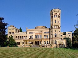 Neetzow Castle | |
Location of Neetzow  | |
 Neetzow  Neetzow | |
| Coordinates: 53°53′N13°25′E / 53.883°N 13.417°E | |
| Country | Germany |
| State | Mecklenburg-Vorpommern |
| District | Vorpommern-Greifswald |
| Municipality | Neetzow-Liepen |
| Area | |
• Total | 25.18 km2 (9.72 sq mi) |
| Elevation | 12 m (39 ft) |
| Population (2012-12-31) | |
• Total | 578 |
| • Density | 23/km2 (59/sq mi) |
| Time zone | UTC+01:00 (CET) |
| • Summer (DST) | UTC+02:00 (CEST) |
| Postal codes | 17391 |
| Dialling codes | 039723 |
| Vehicle registration | OVP |
| Website | www.amt-anklam-land.de |
Neetzow is a village and a former municipality in the Vorpommern-Greifswald district, in Mecklenburg-Vorpommern, Germany. Since 1 January 2014, it is part of the municipality Neetzow-Liepen.