
Interstate 10 (I-10) is the southernmost transcontinental highway in the Interstate Highway System. I-10 is the fourth-longest Interstate in the United States at 2,460.34 miles (3,959.53 km), following I-90, I-80, and I-40. This freeway is part of the originally planned network that was laid out in 1956, and its last section was completed in 1990.

McLennan County is a county located on the Edwards Plateau in Central Texas. As of the 2020 census, its population was 260,579. Its county seat and largest city is Waco. The U.S. census 2022 county population estimate is 266,836. The county is named for Neil McLennan, an early Scottish settler who worked to evict the Indians in frontier Texas. McLennan County is included in the Waco Metropolitan Statistical Area.
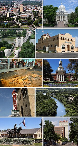
Waco is the county seat of McLennan County, Texas, United States. It is situated along the Brazos River and I-35, halfway between Dallas and Austin. The city had a 2020 population of 138,486, making it the 22nd-most populous city in the state. The Waco metropolitan statistical area consists of McLennan, Falls and Bosque counties, which had a 2020 population of 295,782. Bosque County was added to the Waco MSA in 2023. The 2023 U.S. census population estimate for the Waco metropolitan area was over 300,000 residents.

The Brazos River, called the Río de los Brazos de Dios by early Spanish explorers, is the 14th-longest river in the United States at 1,280 miles (2,060 km) from its headwater source at the head of Blackwater Draw, Roosevelt County, New Mexico to its mouth at the Gulf of Mexico with a 45,000-square-mile (116,000 km2) drainage basin. Being one of Texas' largest rivers, it is sometimes used to mark the boundary between East Texas and West Texas.

A deadly series of at least 33 tornadoes hit at least 10 different U.S. states on May 9–11, 1953. Tornadoes appeared daily from Minnesota in the north to Texas in the south. The strongest and deadliest tornado was a powerful F5 tornado that struck Waco, Texas on May 11, causing 114 of the 144 deaths in the outbreak. Alongside the 1902 Goliad tornado, it was the deadliest tornado in Texas history and is the 11th deadliest tornado in U.S. history. The tornado's winds demolished more than 600 houses, 1,000 other structures, and over 2,000 vehicles. 597 injuries occurred, and many survivors had to wait more than 14 hours for rescue. The destruction dispelled a myth that the geography of the region spared Waco from tornadoes, and along with other deadly tornadoes in 1953, the Waco disaster was a catalyst for advances in understanding the link between tornadoes and radar-detected hook echoes. It also generated support for improved civil defense systems, the formation of weather radar networks, and improved communications between stakeholders such as meteorologists, local officials, and the public.
The list of neighborhoods of Kansas City, Missouri has nearly 240 neighborhoods. The list includes only Kansas City, Missouri and not the entire Kansas City metropolitan area, such as Kansas City, Kansas.
The Heart of Texas Council of Governments (HOTCOG) is a voluntary association of cities, counties and special districts in Central Texas.

Lake Waco is a man-made reservoir located on the west side of Waco, in McLennan County, Texas. It provides water to several cities in the Waco Metropolitan Statistical Area, including Waco, Bellmead, Hewitt, Robinson, Woodway and others in the Cross Timbers and Prairies ecoregion of Texas. Lake Waco was formed by a dam built on the Bosque River basin. The lake has 79,000 acre-feet (97,000,000 m3) of water and is managed by the U.S. Army Corps of Engineers.
Midway Independent School District is a public school district based in Woodway, Texas, USA.
Portland, Oregon is divided into six sections: North Portland, Northeast Portland, Northwest Portland, South Portland, Southeast Portland, and Southwest Portland. There are 95 officially recognized neighborhoods, each of which is represented by a volunteer-based neighborhood association. No neighborhood associations overlap the Willamette River, but a few overlap the addressing sextants. For example, most addresses in the South Portland Neighborhood Association are South, but a portion of the neighborhood is west of SW View Point Terrace where addresses have a SW prefix. Similarly the Buckman Neighborhood Association spans both NE and SE Portland.
The city of San Antonio in the U.S. state of Texas is composed of a number of neighborhoods and districts, spreading out surrounding the central Downtown Area.

Interstate 35 (I-35) in Texas is a major north–south Interstate Highway running from Laredo near the Mexican border to the Red River north of Gainesville where it crosses into Oklahoma. Along its route, it passes through the cities of San Antonio, Austin, and Waco before it splits into two auxiliary routes just north of Hillsboro. I-35E heads northeast where it passes through Dallas. I-35W turns northwest to run through Fort Worth. The two branches meet up in Denton to again form I-35, where it continues to the Oklahoma state line. The exit numbers for I-35E maintain the sequence of exit numbers from the southern segment of I-35, and the northern segment of I-35 follows on from the sequence of exit numbers from I-35E. I-35W maintains its own sequence of exit numbers.

Downtown Austin is the central business district of Austin, Texas, United States. The area of the district is bound by Lamar Boulevard to the west, Martin Luther King Jr. Boulevard to the north, Interstate 35 to the east, and Lady Bird Lake to the south.
The Waco metropolitan statistical area, as defined by the United States Census Bureau, is an area consisting of McLennan, Falls and Bosque counties in Central Texas, anchored by the city of Waco. As of the 1 April 2020 census, the MSA had a population of 295,782. The 2023 population estimate was over 300,000 which includes Bosque County.

The city of Billings, Montana is subdivided into 11 sections for geographic and planning purposes.