
Riga is the capital, the primate, and the largest city of Latvia. Home to 605,273 inhabitants, the city accounts for a third of Latvia's total population. The population of Riga metropolitan area, which stretches beyond the city limits, is estimated at 860,142. The city lies on the Gulf of Riga at the mouth of the Daugava river where it meets the Baltic Sea. Riga's territory covers 307.17 km2 (118.60 sq mi) and lies 1–10 m (3–33 ft) above sea level on a flat and sandy plain.

Historical Latvian Lands or formerly Cultural regions of Latvia are several areas within Latvia formally recognised as distinct from the rest of the country. These are: Kurzeme (Courland), Zemgale (Semigallia), Latgale (Latgalia), Vidzeme, and Sēlija (Selonia). While some of these regions are seen purely as culturally distinct, others have historically been parts of different countries and have been used to divide the country for administrative and other purposes.

Riga City Council is the government of the city of Riga, the capital of Latvia. Its meeting place is in the Riga Town Hall at the Town Hall Square (Rātslaukums) in the very heart of Riga.

Romania's administration is relatively centralized and administrative subdivisions are therefore fairly simplified.

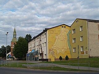
Līvāni is a town in Līvāni Municipality in the Latgale region of eastern Latvia. It is situated at the junction of the Dubna and Daugava rivers, approximately 170 kilometers east of the Latvian capital Riga.

Jaunjelgava is a town on the left bank of the Daugava River in Aizkraukle Municipality, in the Selonia region of Latvia, about 80 km southeast of Riga. The population in 2020 was 1,762.
Many Latvians resisted the occupation of Latvia by Nazi Germany. Independent Latvia had been occupied by the Soviet Union in June 1940, then by Nazi Germany in July 1941, forming Generalbezirk Lettland. The Latvian resistance movement was divided between the pro-independence units under the Latvian Central Council and the pro-Soviet units under the Central Staff of the Partisan Movement in Moscow. Daugavpils was the scene of fierce Jewish resistance during the Holocaust. Many local Latvians were actively involved in the resistance movement against the ethnic policies of the German occupation regime. 134 Latvians were later honored with the title Righteous Among the Nations, among them is Žanis Lipke, who risked his life to save more than 50 Jews.

Zolitūde is mainly an apartment house neighbourhood located in the western part of Riga, the capital of Latvia. Zolitūde is a centrally planned estate, consisting mostly of prefabricated concrete block Brutalist style homes built in late Soviet times. Construction started in 1984, and was mostly halted in 1991, when Latvia obtained its independence from the USSR. Large parts of the population, as in similar neighbourhoods of Riga, are Russian speaking. Zolitūde had been a mixture of council housing and co-operative flats, but many properties have been privatised since the fall of the Soviet Union.

Purvciems is a neighbourhood in the Vidzeme Suburb of Riga, Latvia. Its name literally translates as "marsh village". It is located on the east bank of the River Daugava, to the east of the City Centre and is defined roughly as the area between A. Deglava Iela and Ieriķu Iela. The area is characterised by apartment blocks from the late Soviet and the first years after the restoration of Latvian independence (1980s–1990s), though there is also some detached housing. The district is Latvian and Russian-speaking.

There are five planning regions of Latvia ; Kurzeme, Latgale, Riga, Vidzeme and Zemgale. The boundaries of the regions aligns to the boundaries of the municipalities of Latvia following the municipality reform of 1 July 2009. The planning regions of Latvia are not administrative territorial divisions, since they are not mentioned in the law that prescribes the administrative territorial divisions of Latvia. They were replaced with new planning regions in 2021.

Ādaži Municipality is a municipality in the historical region of Vidzeme, and the Riga Planning Region in Latvia, which consists of Ādaži and Carnikava Parish plus the administrative centre, Ādaži. The municipality is located 25 km from the center of Riga.

Mārupe Municipality is a municipality in Latvia, mostly in Vidzeme region, immediately to the southwest of the capital city of Riga. The municipality was formed in 2009 by reorganization of Mārupe Parish. The administrative centre is the town of Mārupe. The municipality borders the city of Riga to its east and north-east, the city of Jurmala to its north, and the municipalities of Tukums to its west, Jelgava to its southwest, Olaine to its south and southeast.
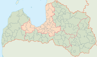
Riga Region, officially Riga Planning Region and shortened as RPR is one of five planning regions of Latvia, situated in the central part of Latvia, in and around the metropolis of Riga and along the shores of the Gulf of Riga. The state institution was founded on 12 October 2006, based on the creation of the region territory as prescribed by Regulations No. 133 of the Cabinet of Ministers as of 25 March 2003, the "Regulations on Territories of Planning Regions". After the 2021 reform some Riga Region's lands were incorporated into Kurzeme and Vidzeme.

Kurzeme Region, officially Kurzeme Planning Region, is one of the five planning regions of Latvia, it is situated in the western part of Latvia, at the shores of the Baltic Sea and Gulf of Riga. The state institution was founded on 2 October 2006, based on the creation of the region territory as prescribed by Regulations No. 133 of the Cabinet of Ministers as of 25 March 2003, the "Regulations on Territories of Planning Regions". As of 2020, the region's population was 237,407.
Buļļi or Rītabuļļi is a neighbourhood of Riga, the capital of Latvia. The Western area is known as Vakarbuļļi.
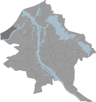
The administrative divisions of Riga consists of six administrative entities: Central District, Kurzeme District, Latgale Suburb, Northern District, Vidzeme Suburb and Zemgale Suburb. Three entities were established 1 September 1941, and another three were established in October 1969. There are no official lower level administrative units, but the Riga City Council Development Agency is working on a plan, which when officially confirmed, will mean that Riga will consist of 58 neighbourhoods. The current names were confirmed 28 December 1990.
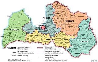
There are six statistical regions in Latvia are Kurzeme, Latgale, Pierīga, Rīga, Vidzeme and Zemgale.

The first Krišjānis Kariņš' cabinet was the 40th government of Latvia, sworn in on 23 January 2019 after Krišjānis Kariņš was proposed as Prime Minister by President Raimonds Vējonis and elected by the Saeima and working until 14 December 2022, when Saeima passed a motion of confidence in the Second Kariņš' cabinet.

Mežaparks is a large urban park in the Mežaparks neighbourhood of Riga, the capital of Latvia. The park is home to the open-air Mežaparks Great Bandstand and has Riga Zoo located next to it as well as access to Ķīšezers lake. The 424 ha territory is covered with coastal dunes, much of it with boreal forests, both protected conserved biotopes. The territory began to be used for recreation in the 18th century and was added to Riga's territory in the 19th century. In 1901, the Mežaparks neighbourhood became Russian Empire's first architectural project to use the garden city movement. The area was expanded and developed during the first half of the 20th century, primarily serving as an elite sports complex. After World War II in 1949, the Soviet Government carried out a major expansion of the park and inaugurated it as a public park with many recreational areas and buildings. Up until the end of the 20th century, the park continued to serve as a public park. Although little of the Soviet architecture survives, the park has seen a resurgence after restoration of Latvia's independence and is currently a popular recreational location. The park and the neighbourhood are a national heritage site and architectural cultural monuments.
Valmiera Municipality is one of the 35 municipalities established in Latvia in 2021, located approximately 180 kilometres (110 mi) west of the national capital Riga. Its first elected municipal council took office on 1 July 2021. Its seat is the city of Valmiera.
