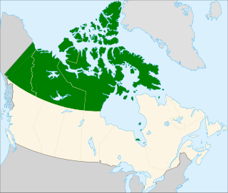
The Northwest Passage (NWP) is, from the European and northern Atlantic point of view, the sea route to the Pacific Ocean through the Arctic Ocean, along the northern coast of North America via waterways through the Canadian Arctic Archipelago. The eastern route along the Arctic coasts of Norway and Siberia is accordingly called the Northeast Passage (NEP).

Hudson Strait links the Atlantic Ocean and Labrador Sea to Hudson Bay in Canada. This strait lies between Baffin Island and Nunavik, with its eastern entrance marked by Cape Chidley in Newfoundland and Labrador and Resolution Island off Baffin Island. The strait is about 750 km long with an average width of 125 km, varying from 70 km at the eastern entrance to 240 km at Deception Bay.

Victoria Island is a large island in the Canadian Arctic Archipelago that straddles the boundary between Nunavut and the Northwest Territories of Canada. It is the eighth largest island in the world, and at 217,291 km2 (83,897 sq mi) in area, it is Canada's second largest island. It is nearly double the size of Newfoundland (111,390 km2 [43,008 sq mi]), and is slightly larger than the island of Great Britain (209,331 km2 [80,823 sq mi]) but smaller than Honshu (225,800 km2 [87,182 sq mi]). It contains the world's largest island within an island within an island. The western third of the island belongs to the Inuvik Region in the Northwest Territories; the remainder is part of Nunavut's Kitikmeot Region.

The Arctic Archipelago, also known as the Canadian Arctic Archipelago, groups together all islands lying to the north of the Canadian continental mainland excluding Greenland.

Chukchi Sea, sometimes referred to as the Chukotsk Sea or the Sea of Chukotsk, is a marginal sea of the Arctic Ocean. It is bounded on the west by the Long Strait, off Wrangel Island, and in the east by Point Barrow, Alaska, beyond which lies the Beaufort Sea. The Bering Strait forms its southernmost limit and connects it to the Bering Sea and the Pacific Ocean. The principal port on the Chukchi Sea is Uelen in Russia. The International Date Line crosses the Chukchi Sea from northwest to southeast. It is displaced eastwards to avoid Wrangel Island as well as the Chukotka Autonomous Okrug on the Russian mainland.

Axel Heiberg Island is an island in the Qikiqtaaluk Region, Nunavut, Canada. Located in the Arctic Ocean, it is the 32nd largest island in the world and Canada's seventh largest island. According to Statistics Canada, it has an area of 43,178 km2 (16,671 sq mi). It is named after Axel Heiberg.

Bylot Island lies off the northern end of Baffin Island in Nunavut Territory, Canada. Eclipse Sound to the southeast and Navy Board Inlet to the southwest separate it from Baffin Island. Parry Channel lies to its northwest. At 11,067 km2 (4,273 sq mi) it is ranked 71st largest island in the world and Canada's 17th largest island. The island measures 180 km (110 mi) east to west and 110 km (68 mi) north to south and is one of the largest uninhabited islands in the world. While there are no permanent settlements on this Canadian Arctic island, Inuit from Pond Inlet and elsewhere regularly travel to Bylot Island. An Inuit seasonal hunting camp is located southwest of Cape Graham Moore.

Amundsen Gulf is a gulf located in the Northwest Territories, Canada, between Banks Island and Victoria Island and the mainland. It is approximately 250 mi (400 km) in length and about 93 mi (150 km) across where it meets the Beaufort Sea.

Arthur Harbour is a small harbour entered between Bonaparte Point and Amsler Island on the south-west coast of Anvers Island in the Palmer Archipelago of Antarctica.

Roberts Memorial Provincial Park is a 14 ha provincial park in British Columbia, Canada, located 15 km south of Nanaimo.
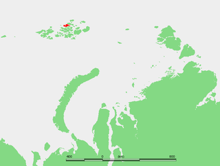
Jackson Island is an island located in Franz Josef Land, Arkhangelsk Oblast, Russian Federation. This island is part of the Zichy Land subgroup of the central part of the archipelago.

Vladimir Ivanovich Voronin was a Soviet Navy captain, born in Sumsky Posad, in the present Republic of Karelia, Russia. In 1932 he commanded the expedition of the Soviet icebreaker Alexander Sibiryakov which made the first successful crossing of the Northern Sea Route in a single navigation without wintering. This voyage was organized by the All-Union Arctic Institute.

Cape Fullerton is a cape and peninsula in the Kivalliq Region of Nunavut, Canada located on the northwest shores of Hudson Bay on Roes Welcome Sound and includes Fullerton Harbour. Today it is part of Ukkusiksalik National Park. Although Cape Fullerton was traditionally home to migrant Inuit people including the Aivilingmiut and the Qaernermiut, today the nearest permanently populated settlement is Chesterfield Inlet, roughly 100 kilometers to the southwest.

Dundas Harbour is an abandoned settlement in Qikiqtaaluk, Nunavut, Canada. It is located on Devon Island at the eastern shore of the waterway also named Dundas Harbour. Baffin Bay's Croker Bay is immediately to the west.

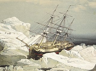
The McClure Arctic expedition of 1850, among numerous British search efforts to determine the fate of the Franklin's lost expedition, is distinguished as the voyage during which the Irish explorer Robert McClure became the first person to confirm and transit the Northwest Passage by a combination of sea travel and sledging.
Cape Parry is a headland in Canada's Northwest Territories. Located at the northern tip of the Parry Peninsula, it projects into Amundsen Gulf. The nearest settlement is Paulatuk, 100 km (62 mi) to the south, and Fiji Island is located 9 km (5.6 mi) to the west. Cape Parry was formerly accessible through Cape Parry Airport that was located at the Distant Early Warning Line. The airport was listed as abandoned after the closure of the DEW line site.

The borders of the oceans are the limits of the Earth's oceanic waters. The definition and number of oceans can vary depending on the adopted criteria.
Fowlie Glacier is a tributary glacier, 13 nautical miles (24 km) long, in the Admiralty Mountains of Victoria Land, Antarctica. From a common head with Dennistoun Glacier, it flows northwest between Mount Ajax and Mount Faget, entering the main flow of the Dennistoun Glacier at the southeast base of the Lyttelton Range. It was named after Walter Fowlie of the New Zealand Antarctic Division, a field assistant with a New Zealand Antarctic Research Programme geological party to this area, 1981–82, led by R.H. Findlay. The original application of the name was revised in 1994 in relation to Dennistoun Glacier. This glacier lies situated on the Pennell Coast, a portion of Antarctica lying between Cape Williams and Cape Adare.
Cape Hattersley-Smith is a cape marked by a triangular rock peak at the southeast end of Condor Peninsula, 5 nautical miles (9 km) southwest of Cape Knowles, on the Black Coast of Palmer Land, Antarctica. The cape was photographed from the air by the United States Antarctic Service on December 30, 1940. It was surveyed by the Falkland Islands Dependencies Survey (FIDS)–Ronne Antarctic Research Expedition party from Stonington Island in November 1947 and was rephotographed by the U.S. Navy in 1966.