Related Research Articles
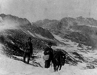
The Pike's Peak gold rush was the boom in gold prospecting and mining in the Pike's Peak Country of western Kansas Territory and southwestern Nebraska Territory of the United States that began in July 1858 and lasted until roughly the creation of the Colorado Territory on February 28, 1861. An estimated 100,000 gold seekers took part in one of the greatest gold rushes in North American history.

Butte County is a county located in the northern central part of the U.S. state of California. In the 2020 census, its population was 211,632. The county seat is Oroville.

Plumas County is a county in the Sierra Nevada of the U.S. state of California. As of the 2020 census, the population was 19,790. The county seat is Quincy, and the only incorporated city is Portola. The largest community in the county is East Quincy. The county was named for the Spanish Río de las Plumas, which flows through it. The county itself is also the namesake of a native moth species, Hadena plumasata.

Sierra County is a county located in the U.S. state of California. As of the 2020 census, the population was 3,236, making it California's second-least populous county. The county seat is Downieville; the sole incorporated city is Loyalton. The county is in the Sierra Nevada, northeast of Sacramento on the border with Nevada.

La Porte is a census-designated place (CDP) in Plumas County, California, United States. The population was 65 at the 2020 census. The town was first known as Rabbit Creek until 1857.
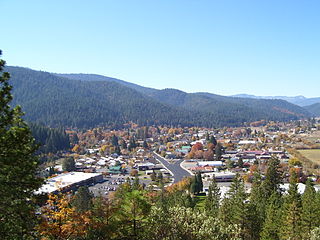
Quincy is a census-designated place and the county seat of Plumas County, California. The population was 1,630 during the 2020 Census, down from 1,728 during the 2010 Census, and 1,879 during the 2000 Census.

The Gold Country is a historic region in the northern portion of the U.S. state of California, that is primarily on the western slope of the Sierra Nevada. It is famed for the mineral deposits and gold mines that attracted waves of immigrants, known as the 49ers, during the 1849 California Gold Rush.

The Feather River is the principal tributary of the Sacramento River, in the Sacramento Valley of Northern California. The river's main stem is about 73 miles (117 km) long. Its length to its most distant headwater tributary is just over 210 miles (340 km). The main stem Feather River begins in Lake Oroville, where its four long tributary forks join—the South Fork, Middle Fork, North Fork, and West Branch Feather Rivers. These and other tributaries drain part of the northern Sierra Nevada, and the extreme southern Cascades, as well as a small portion of the Sacramento Valley. The total drainage basin is about 6,200 square miles (16,000 km2), with approximately 3,604 square miles (9,330 km2) above Lake Oroville.
Plumas Lake is a master-planned exurb and census-designated place in Yuba County, California. It is located 30 miles (48 km) north of Sacramento and 10 miles (16 km) south of Marysville off California State Route 70. Its population was 8,126 at the 2020 census.

State Route 49 is a north–south state highway in the U.S. state of California that passes through many historic mining communities of the 1849 California gold rush and it is known as the Golden Chain Highway. The highway's creation was lobbied by the Mother Lode Highway Association, a group of locals and historians seeking a single highway to connect many relevant locations along the Gold Rush to honor the 49ers. One of the bridges along SR 49 is named for the leader of the association, Archie Stevenot.

Lake Oroville is a reservoir formed by the Oroville Dam impounding the Feather River, located in Butte County, northern California. The lake is situated 5 miles (8 km) northeast of the city of Oroville, within the Lake Oroville State Recreation Area, in the western foothills of the Sierra Nevada. Known as the second-largest reservoir in California, Lake Oroville is treated as a keystone facility within the California State Water Project by storing water, providing flood control, recreation, freshwater releases to assist in controlling the salinity intrusion into the Sacramento-San Joaquin Delta and protecting fish and wildlife.

Elizabethtown, California was a California Gold Rush town that began in 1852 in Plumas County, California. It was named after a woman in the miners camp called Elizabeth Stark Blakesley.
Merrimac was an unincorporated community in Butte County, California located along Oroville-Quincy Road about 2.1 miles (3.4 km) south of the Plumas County line at an elevation of 3999 feet. Nearby is Rogers Cow Camp, a campground in Lassen National Forest.
Mount Ophir is a ghost town in Mariposa County, California. It was a mining town founded in 1850 during the California Gold Rush, and was the site of the Mount Ophir Mint, the first authorized mint in California.
Woodleaf is an unincorporated community in Yuba County, California. It is located 2.5 miles (4.0 km) northeast of Challenge, at an elevation of 3133 feet.
Blue Mountain City is a former settlement in Calaveras County, California, along Licking Fork, approximately 20 miles (32 km) northeast of Mountain Ranch. The town was built on a flat bench of land above the mining camp which perched on a steep canyon slope on the west side of Licking Fork, just over a mile downstream from the headwaters. The town was first announced in January, 1863. The Heckendorn Gold and Silver Mining Company was organized by July, with C. C. Bowman as its secretary. A post office operated in Blue Mountain from 1863 to 1864.
Atlanta is an unincorporated community located in San Joaquin County, California. Its elevation is 62 ft and is located at 37°48′47″N121°07′15″W.
James Humphrey Haun (1811-1890) was a gold miner, farmer and diarist. He left five volumes of diaries chronicling the California Gold Rush and its aftermath, from 1853-1959. His records are stored at the Plumas County Museum in Quincy, California
The Lost Sierra is the northern Sierra Nevada region in California in the United States. It encompasses the area of Plumas and Sierra Counties.
The site of the Old Mining Camp of Brownsville is a California Historical Landmark on Pennsylvania Gulch Road east of the town of Murphys, California in Calaveras County. The Mining Camp of Brownsville was a California Gold Rush camp in Pennsylvania Gulch in from 1850 to 1870. The camp is named after Alfred Brown, who was the former owner of the Table Mountain Ranch. There were many rich mines in the area and Brownsville Mining Camp supported this activity. So rich was the area, the Brownsville Mining District limited the size of mines in the District. Each miner could claim and own only one wet and one dry site, no larger than 150 square feet each. Brownsville Mining District was in the area of Pennsylvania Gulches and Missouri Gulches 2 miles from Murphys. There are no remains of the camp, but nearby is the Brownsville Mining District Cemetery. A plaque monument was dedicated on July 19, 1953, by California State Park Commission with the monument base built by Christa Parlor No. 137 and Ruby Parlor No. 49 of the Native Daughters of the Golden West.
References
- ↑ "Haun Collection Archive". Archived from the original on 2017-05-20. Retrieved 2017-05-20.
- ↑ Matuszak, David. Nelson Point: A Portrait of a Northern Gold Rush Town.