Nemio River

Last updated
Nemio
Gouin Reservoir 74.72W 48.61.jpg
Map of Saint-Maurice River watershed
Location
Country Canada
Province Quebec
Region Mauricie
Physical characteristics
SourceDugré Lake
  location La Tuque (Tassé Township), Mauricie, Quebec
  coordinates 48°09′41″N74°47′43″W / 48.16139°N 74.79528°W / 48.16139; -74.79528
  elevation443 m (1,453 ft)
Mouth Bureau Lake
  location
La Tuque, Mauricie, Quebec
  coordinates
48°30′43″N75°00′02″W / 48.51194°N 75.00056°W / 48.51194; -75.00056 Coordinates: 48°30′43″N75°00′02″W / 48.51194°N 75.00056°W / 48.51194; -75.00056
  elevation
402 m (1,319 ft)
Length60.2 km (37.4 mi) [1]

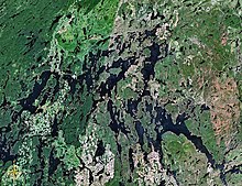
The Nemio River is a tributary of the south shore of the Gouin Reservoir, flowing in the town of La Tuque, in the administrative region of Mauricie, in Quebec, in Canada.

Gouin Reservoir reservoir in Haute-Mauricie (Quebec, Canada)

The Gouin Reservoir is a man-made lake, in La Tuque, in Mauricie, in the central portion of the Canadian provinceof Quebec, fully within the boundaries of the City of La Tuque. It is not one contiguous body of water, but the collective name for a series of connected lakes separated by innumerable bays, peninsulas, and islands with highly irregular shapes. It has therefore a relative long shoreline of over 5,600 km compared to its surface area of 1,570 km². It is the source of the Saint-Maurice River.

Mauricie Administrative region in Quebec, Canada

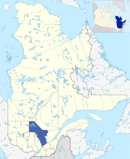
Mauricie is a traditional and current administrative region of Quebec. La Mauricie National Park is contained within the region, making it a prime tourist location. The region has a land area of 35,855.22 km² and a 2006 census population of 258,928 residents. Its largest cities are Trois-Rivières and Shawinigan.

Quebec Province of Canada

Quebec is one of the thirteen provinces and territories of Canada. It is bordered to the west by the province of Ontario and the bodies of water James Bay and Hudson Bay; to the north by Hudson Strait and Ungava Bay; to the east by the Gulf of Saint Lawrence and the province of Newfoundland and Labrador; and to the south by the province of New Brunswick and the US states of Maine, New Hampshire, Vermont, and New York. It also shares maritime borders with Nunavut, Prince Edward Island, and Nova Scotia. Quebec is Canada's largest province by area and its second-largest administrative division; only the territory of Nunavut is larger. It is historically and politically considered to be part of Central Canada.

Contents

The Nemio River flows successively into the townships of Tassé, Huguenin, Sulte, Chapman, Myrand and Lemay, on the southern shore of the Gouin Reservoir. Forestry is the main economic activity of this valley; recreational tourism activities, second.

The route 404, connecting the village of Clova, Quebec to the South Bay of Bureau Lake is connected to sub-road branches which serve the upper part of the Nemio River; this road connects to the south-east the route 400 which goes to Gouin Dam. Some secondary forest roads are in use nearby for forestry and recreational tourism activities.

Clova, Quebec Place in Quebec, Canada

Clova is a hamlet within the city of La Tuque, in the Mauricie region, in Quebec, Canada. It is also the name of a post office in Clova, a dam and a power plant. Clova is known for the Clova station, built as part of the National Transcontinental Railway, now part of the Canadian National Railway.

Bureau Lake part of Gouin Reservoir, Mauricie, Quebec, Canada

The Lac Bureau is a vast freshwater body of the southwestern part of the Gouin Reservoir, in the territory of the town of La Tuque, in Haute-Mauricie, in the administrative region of Mauricie, in the province of Quebec, in Canada.

The surface of the Nemio River is usually frozen from mid-November to the end of April, however, safe ice circulation is generally from early December to late March.

Geography

The surrounding hydrographic slopes of the Nemio River are:
Du Mâle Lake (Gouin Reservoir) part of the Gouin Reservoir, in La Tuque, Mauricie, Quebec (Canada)

The Male Lake is a freshwater body located in the western part of the Gouin Reservoir, in the territory of the town of La Tuque, in the administrative region of the Mauricie, in the province of Quebec, in Canada.

Chapman Lake (Gouin Reservoir) lake of Gouin Reservoir, in Mauricie (Quebec, Canada)

The Chapman Lake is a vast expanse of freshwater in the central part of the Gouin Reservoir, in the territory of the town of La Tuque, in Haute-Mauricie, in the administrative region of Mauricie, in the province of Quebec, in Canada.

Bouzanquet Bay Gouin Reservoir Bay, in Haute-Mauricie (Quebec, Canada)

The Bouzanquet Bay is a vast freshwater body of the south-eastern part of the Gouin Reservoir, in the territory of the town of La Tuque, in Haute-Mauricie, in the administrative region of Mauricie, in the province of Quebec, in Canada.

The Nemio River originates at the mouth of Lac Dugré (length: 9.1 kilometres (5.7 mi) crescent-shaped, elevation: 443 metres (1,453 ft)). The mouth of this head lake is located at:

Obedjiwan, Quebec First Nations reserve in Quebec, Canada

Obedjiwan is a First Nations reserve and village on the north shore of Gouin Reservoir in the Mauricie region of Quebec, Canada. It belongs to the Atikamekw d'Opitciwan band of the Atikamekw Nation.

Saint-Maurice River river of the North shore of St. Lawrence, in Mauricie, in Quebec, in Canada

The Saint-Maurice River flows North to South in central Quebec from Gouin Reservoir to empty into the Saint Lawrence River at Trois-Rivières, in the province of Quebec, in Canada. From its source at Gouin Reservoir, located at the same latitude as the Lac Saint-Jean, the river has a total drop of about 405 meters, to finally reach the St. Lawrence river at Trois-Rivières. The river is 563 km in length and has a drainage basin of 43,300 km². Saint-Maurice river is one of the most important tributaries of the St. Lawrence river.

From the mouth of the head lake, the Nemio River flows over 60.2 kilometres (37.4 mi) according to the following segments:

Upper part of the Nemio River (segment of 43.2 kilometres (26.8 mi))

Lower part of the Nemio River (segment of 17 kilometres (11 mi))

In its lower part, the Nemio River crosses Nemio Bay. The mouth of the Nemio River is located at:

The mouth of the Nemio River merges with the North Bay of Bureau Lake (Gouin Reservoir). From there, the current flows over 100.8 kilometres (62.6 mi) until Gouin dam, according to the following segments:

From this dam, the current flows along the Saint-Maurice River to Trois-Rivières.

Toponymy

The toponym "Nemio River" was formalized on December 5, 1968 at the Commission de toponymie du Québec, when it was created. [5]

Notes and references

  1. "Atlas of Canada". atlas.nrcan.gc.ca. Retrieved 2018-03-24.
  2. Distances from the Atlas of Canada (published on the Internet) of the Ministry of Natural Resources. Canada.
  3. Measured river segments from the Atlas of Canada (published on the Internet) of the Department of Natural Resources Canada.
  4. Distances measured from the Atlas of Canada (published on the Internet) of the Department of Natural Resources Canada.
  5. Commission de toponymie du Quebec - Bank of Place Names - Toponym: "Nemio River"

See also

Map all coordinates using: OpenStreetMap  
Download coordinates as: KML  ·  GPX

Related Research Articles

Oskélanéo Lake tributary of Gouin Reservoir, in La Tuque, Mauricie, Quebec, Canada

Oskélanéo Lake is a freshwater body linked to the southwestern part of the Gouin Reservoir (via Bureau Lake, in the territory of the town of La Tuque, in the administrative region of Mauricie, in the province of Quebec, in Canada.

Mistatikamekw River tributary of the Gouin Reservoir, in La Tuque, Mauricie, Quebec, in Canada

The Mistatikamekw River is a tributary of the Oskélanéo River which flows into the South Bay of Bureau Lake, flowing into the town of La Tuque, in the administrative region of Mauricie, in Quebec, in Canada.

The Flapjack River is a tributary of the Mattawa Bay of the Southwest of Gouin Reservoir, flowing into the town of La Tuque, into the administrative area of the Mauricie, in Quebec, in Canada.

Mattawa Bay Gouin Reservoir Bay, in La Tuque (Quebec, Canada)

Mattawa Bay is a freshwater body of the southwestern part of the Gouin Reservoir in the territory of the town of La Tuque, in the Mauricie administrative region, in the province of Quebec, in Canada.

Saraana Bay is a freshwater body of the southwestern part of Gouin Reservoir, in the territory of the town of La Tuque, in the administrative region of Mauricie, in the province of Quebec, in Canada.

Tessier Lake lake on South slope of Gouin Reseroir, La Tuque, Mauricie (Quebec, Canada)

The Tessier Lake is a freshwater body located on the south side of the southwestern part of the Gouin Reservoir, in the territory of the town of La Tuque, in the region of Mauricie, in the province of Quebec, in Canada.

The Faucher River is a tributary of Tessier Lake located on the southwestern side of the Gouin Reservoir. This river runs in the town of La Tuque, in the administrative region of Mauricie, in Quebec, in Canada.

Bignell Creek is a tributary of the Adolphe-Poisson Bay located on the southwestern side of the Gouin Reservoir. This stream runs entirely in forest zone in the town of La Tuque, in the administrative region of Mauricie, in Quebec, in Canada.

Plamondon Bay Gouin Reservoir Bay, in La Tuque, Mauricie (Quebec, Canada)

Plamondon Bay is a body of freshwater located in the western part of Gouin Reservoir, in the territory of the town of La Tuque, in the administrative region of the Mauricie, in the province of Quebec, in Canada.

The Plamondon Creek is a tributary of the Plamondon Bay located in the western part of the Gouin Reservoir. This stream runs entirely in forest zone in the town of La Tuque, in the administrative region of Mauricie, in Quebec, in Canada.

Bourgeois Lake Lac du Reservoir Gouin, in La Tuque, Mauricie (Quebec, Canada)

The Bourgeois Lake is a freshwater body located in the north central part of the Gouin Reservoir, in the territory of the town of La Tuque, in the administrative region of the Mauricie, in the province of Quebec, in Canada.

Thibodeau Bay part of the Gouin Reservoir, in La Tuque, Mauricie (Quebec, Canada)

Thibodeau Bay is a freshwater body located in the north central part of the Gouin Reservoir, in the territory of the town of La Tuque, in the administrative region of the Mauricie, in the province of Quebec, in Canada.

The Piponisiw River is a tributary of Simard Lake located in the western part of the Gouin Reservoir, flowing entirely into the forest zone in the town of La Tuque, in the administrative region of Mauricie, Quebec, Canada.

Simard Lake lake in Quebec, Canada

The Simard Lake is a freshwater body located in the northwestern part of Gouin Reservoir, in the territory of the town of La Tuque, in the administrative region of Mauricie, in the province of Quebec, in Canada.

Piciw Minikanan Bay Gouin Reservoir Bay, in La Tuque, Mauricie (Quebec, Canada)

Piciw Minikanan Bay is a body of freshwater located in the western part of Gouin Reservoir, in the territory of the town of La Tuque, in the administrative area of the Mauricie, in the province of Quebec, in Canada.

Miller Lake (Gouin Reservoir) lake in La Tuque, Quebec, Canada; ; latitude 48.66, longitude -75.15

Miller Lake is a body of freshwater located in the western part of the Gouin Reservoir, in the territory of the town of La Tuque, in the administrative region of the Mauricie, in the province of Quebec, in Canada.