Sussex Drive, also known as Ottawa Regional Road 93, is an arterial road in Ottawa, Ontario, the capital of Canada. It is one of the city's main ceremonial and institutional routes. Travelling roughly parallel to the Ottawa River, Sussex Drive begins as a continuation of Sir George-Étienne Cartier Parkway at Rideau Gate, at the entrance to Rideau Hall. It travels south to Rideau Street, with the portion south of St. Patrick Street forming the northbound half of a one-way pair with Mackenzie Avenue. Both Mackenzie Avenue and Sussex Drive connect with Colonel By Drive at their southern end, which continues south alongside the Rideau Canal.

The Lost Villages were ten communities in the Canadian province of Ontario, in the former townships of Cornwall and Osnabruck near Cornwall, which were permanently submerged by the creation of the Saint Lawrence Seaway in 1958.
King's Highway 417, commonly referred to as Highway 417 and as the Queensway through Ottawa, is a 400-series highway in the Canadian province of Ontario. It connects Ottawa with Montreal via A-40, and is the backbone of the highway system in the National Capital Region. Within Ottawa, it forms part of the Queensway west from Highway 7 to Ottawa Road 174. Highway 417 extends from the Quebec border, near Hawkesbury, to Arnprior, where it continues westward as Highway 17. Aside from the urban section through Ottawa, Highway 417 passes through farmland that dominates much of the fertile Ottawa Valley.
State Road 589 (SR 589), also known as the Veterans Expressway and Suncoast Parkway, is a north–south toll road near the Florida Gulf Coast. Maintained and operated by Florida's Turnpike Enterprise, this 68-mile (109 km) transportation corridor extends from State Road 60 in Tampa, north to State Road 44 near Lecanto. The Veterans Expressway was built to accommodate the increasing commuter traffic in the Tampa-St. Petersburg metropolitan area, with the Suncoast Parkway opening in 2001, extending from near the northern terminus of the Veterans Expressway to U.S. Route 98, with a possible northern extension to U.S. Route 19/U.S. Route 98 in Crystal River in Citrus County in the planning and development stages. As of February 28, 2022, Phase I of the extension is now open between US 98 and Florida State Road 44. Phase II, which would further extend the highway to County Road 486, is undergoing the design phase.

The Kichi Zībī Mīkan, formerly the Sir John A. Macdonald Parkway, and previously the Ottawa River Parkway, is a four-lane scenic parkway along the Ottawa River in Ottawa, Ontario, Canada. It runs from Carling Avenue near Connaught Avenue, to Booth Street at the Canadian War Museum and National Holocaust Monument. It is maintained by the National Capital Commission. The speed limit is 60 km/h (37 mph). Bicycles are allowed on the road and on a parallel recreational path along the parkway.

Britannia is a group of neighbourhoods in Bay Ward in the west end of Ottawa, Ontario, Canada. It is located on the Ottawa River across from Aylmer, Quebec, adjacent to its namesake, Britannia Bay, north of Richmond Road, west of the Kichi Zibi Mikan and east of Boyce Avenue. The total population of this area was 6,692 as of the 2016 census. The area constituted a municipal ward from 1973 to 1994.
The Long Sault Parkway is a group of eleven islands west of Cornwall in the Canadian province of Ontario, as well as the name of the 10.1-kilometre (6.3 mi) scenic parkway connecting them. The islands, which include two public beaches and three campgrounds, were created by the flooding of the Long Sault rapids during construction of the St. Lawrence Seaway. The parkway, the islands, and their amenities are maintained by the St. Lawrence Parks Commission.
The Thousand Islands Parkway (often written as 1000 Islands Parkway) is a scenic parkway in the Canadian province of Ontario. It extends easterly from an interchange with Highway 401 in Gananoque for approximately 40 kilometres (25 mi) to rejoin Highway 401 near the community of Butternut Bay, west of Brockville. The parkway follows the north shore of the St. Lawrence River, and was formerly designated Highway 2S (S for Scenic) until 1970. It passes through the communities of Gray's Beach, Halsteads Bay, Ivy Lea, Darlingside, Rockport, Narrows, La Rue Mills and Mallorytown Landing, as well as providing access to the three inland properties of the Thousand Islands National Park. Highway 137, which meets the parkway near its midpoint, provides access to the Interstate 81 in New York via the Thousand Islands Bridge.

The Reber Plan was a late 1940s plan to fill in parts of the San Francisco Bay. It was designed and advocated by John Reber—an actor, theatrical producer, and schoolteacher.
The General Report on the Plan for the National Capital (1946–1950), or Gréber Plan, was a major urban plan developed for Canada's National Capital Region in 1950 by Jacques Gréber, commissioned by the Federal District Commission of Ottawa, Ontario.
Shoal Lake 40 First Nation is an Ojibway or Ontario First Nation reserve located in the Eastman Region of Manitoba and the Kenora District of Ontario. The total registered population in December 2022 was 683, of which the on-reserve population was 306. The First Nation is a member of the Bimose Tribal Council, a Regional Chief's Council that is a member of the Grand Council of Treaty 3.

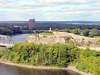
Victoria Island is an island in the Ottawa River, located north of LeBreton Flats, 1 km west of Parliament Hill in Ottawa, Ontario. The island is "a place of special significance" to the local Algonquian peoples, who use the island for ceremonial purposes and for protests. It is part of an archipelago of islands below Chaudière Falls, which also includes the former Philemon Island, Chaudière Island, Amelia Island and Albert Island.

The Britannia Yacht Club (BYC) is a private social club, yacht club, and tennis club based in Britannia, a neighborhood in Ottawa, Ontario, Canada. It was founded in 1887 by a group of cottagers.
The Shah wa Arus Dam is a 75m high concrete gravity dam located in the Shakardara District of Kabul Province in Afghanistan. It has a 60m wide three-bay spillway and is mainly geared towards provision of irrigation water as well as flood control and reliable year-round fresh water supply. Once operational, its power station will produce 1.2 megawatts (MW) of electricity and irrigate 2,700 hectares of land in addition to supplying drinking water for the millions of residents of Kabul.

Britannia United Church is a United Church of Canada congregation in Ottawa, Ontario, Canada. One of Ottawa's oldest congregations, members had been meeting in homes since 1869. The Britannia Heights Methodist Church formed in 1873. It joined the United Church when it was formed in 1925. In 1925, Britannia became officially Britannia United Church. The Britannia United Church has operated out of Pinecrest Road location since 1961.

Potts Hill Reservoirs 1 and 2 are heritage-listed reservoirs at Cooper Road, Potts Hill, City of Canterbury-Bankstown, New South Wales, Australia. It was designed by Board of Water Supply and Sewerage and built from 1880. The reservoirs are now maintained by the Board's successor, Sydney Water. It was added to the New South Wales State Heritage Register on 18 November 1999.

Belltown is a neighbourhood in the Britannia area of Bay Ward, in the west end of Ottawa. It is bounded on the east by Britannia Park, on the north by the Ottawa River, on the west by Andrew Haydon Park and the south by Carling Avenue. Prior to Ottawa's amalgamation in 2001, the neighbourhood spanned the Ottawa-Nepean municipal boundary. The neighbourhood's population is 2089, with 294 people living in the Nepean portion.
The Kinshasa Industrial Water Treatment Complex (KIWTC), is a water purification and distribution project under construction in the Democratic Republic of the Congo (DRC). Construction began in August 2021 and completion is expected in the second half of 2023. The engineering, procurement and construction (EPC) contractor is Weihai International Economic & Technical Cooperative (WIETC), of China. The project is owned and is financed by the government of DRC, with funds borrowed from the World Bank Group.