Related Research Articles
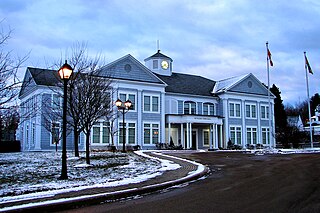
Rothesay is a town located in Kings County, New Brunswick, Canada. It is adjacent to the City of Saint John along the Kennebecasis River.
5th Canadian Division Support Base Gagetown, formerly known as and commonly referred to as CFB Gagetown, is a large Canadian Forces Base covering an area over 1,100 km2 (420 sq mi), located in southwestern New Brunswick.

The Saint John Harbour Bridge is three-span crossing of Saint John Harbour at the mouth of the Saint John River in Saint John, New Brunswick, Canada. It opened in 1968.

Grand Bay-Westfield is a town on the west bank of the Saint John River immediately north of the boundary between Kings County and Saint John County.

Jemseg is a Canadian rural community in Cambridge Parish, Queens County, New Brunswick. It is located on the east bank of the Jemseg River along its short run from Grand Lake to the Saint John River. The village briefly served as the Capital of Acadia (1690–91).
Welsford is a Canadian rural community in Queens County, New Brunswick.
The Jemseg River is a short river in the Canadian province of New Brunswick which drains Grand Lake into the Saint John River.
Browns Flat is a Canadian rural community in Kings County, New Brunswick.
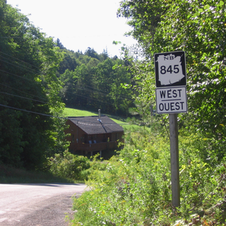
Route 845 is a Canadian highway in Kings County, New Brunswick.
The Kingston Peninsula is a peninsula in southern New Brunswick, Canada, located between the Saint John River and the Kennebecasis River in Kings County.

New Brunswick is one of Canada's three Maritime provinces. While New Brunswick is one of Canada's Maritime Provinces, it differs from its neighbours both ethnoculturally and physiographically. Both Nova Scotia and Prince Edward Island are either wholly or nearly surrounded by water and the ocean, therefore, tends to define their climate, economy and culture. New Brunswick, on the other hand, although having a significant seacoast, is sheltered from the Atlantic Ocean proper and has a large interior that is removed from oceanic effects. New Brunswick, therefore, tends to be defined by its rivers rather than its seacoast.
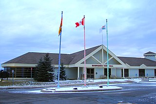
Quispamsis is a Kings County suburb of Saint John, New Brunswick, located 20 kilometres (12 mi) to the northeast in the lower Kennebecasis River valley. Its population was 18,768 as of the 2021 census.
The Nerepis River is a river approximately 25 miles (40 km) long in New Brunswick, Canada. A popular river for canoeists and anglers, it is a tributary of the Saint John River. The river has been subjected to significant environmental stress over many years.

The Westfield Ferry is a cable ferry in the Canadian province of New Brunswick. The ferry crosses the Saint John River, linking Grand Bay–Westfield on the west bank to Hardings Point on the east bank.
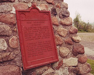
Fort Boishébert is a National Historic Site at Woodmans Point outside the Town of Grand Bay–Westfield, Kings County, New Brunswick, Canada. Located at the confluence of the Saint John River and Nerepis rivers, the fort may have had its origins as a fortified aboriginal village. Joseph Robineau de Villebon noted this in a letter dated October 22, 1696, "Sr. de Neuvillette reported that he was continuing on his way down river and would, as he passed the fort of the Nerepis Indians..." Earlier in October 1696, French soldiers upon being rescued by Nerepis, retreated to Fort Nerepis after being attacked by a small English fleet that had entered Saint John Harbour.
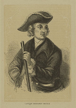
The siege of Fort Nashwaak occurred during King William's War when New England forces from Boston attacked the capital of Acadia, Fort Nashwaak, at present-day Fredericton, New Brunswick. The siege was in retaliation for the French and Indian Siege of Pemaquid (1696) at present day Bristol, Maine. In the English Province of Massachusetts Bay. Colonel John Hathorne and Major Benjamin Church were the leaders of the New England force of 400 men. The siege lasted two days, between October 18–20, 1696, and formed part of a larger expedition by Church against a number of other Acadian communities.
Westfield is a civil parish in Kings County, New Brunswick, Canada.

Burton is a civil parish in Sunbury County, New Brunswick, Canada.
Canning is a civil parish in Queens County, New Brunswick, Canada.
The Grand Bay is a body of water at the confluence of the Wolastoq and Kennebecasis rivers in southern New Brunswick, Canada. The bay is approximately 19.7 km2 and spans across the boundary between Saint John and Kings counties.
References
Coordinates: 45°23′49.21″N66°18′26.26″W / 45.3970028°N 66.3072944°W
| | This New Brunswick location article is a stub. You can help Wikipedia by expanding it. |