Related Research Articles
The Sinni is a 94 km long river in the Basilicata region of southern Italy. In antiquity, the city of Siris lay at its mouth. Near the town of Senise, a dam on the river was built in 1970-1982, the largest in Europe built with earth. In correspondence of it, it forms the Lake Monte Cotugno, one of the largest artificial basins in Italy.
Nyssa was a small town and bishopric in Cappadocia, Asia Minor. It is important in the history of Christianity due to being the see of the prominent 4th century bishop Gregory of Nyssa. Today, its name continues to be used as a titular see in the Eastern Orthodox Church and the Roman Catholic Church.

Neapolis meaning "New City", was an ancient city of Sardinia founded by the Carthaginians in the sixth century BC, and apparently one of the most considerable places on that island. It was situated on the west coast, at the southern extremity of the Gulf of Oristano, at the present-day località of Santa Maria di Nabui, in the comune of Guspini, Province of Medio Campidano.
The Aquae Neapolitanae or Aquae Calidae Neapolitanorum are springs and their adjoining population nucleus mentioned by Ptolemy as well as in the Antonine Itinerary, which places them at a considerable distance inland from Neapolis, on the road from Othoca to Caralis, Sardinia, Italy. They are identified with the mineral sources now known as the Bagni di Sardara, on the high road from Cagliari to Oristano.
Muranum, was an ancient town of the interior of Lucania, the name of which is not found in any ancient author; but its existence is proved by the Itinerary of Antoninus, which places a station "Summurano", evidently a corruption of "Sub Murano", on the road from Nerulum to Consentia ; and this is confirmed by the inscription found at La Polla, which gives the distance from that place to Muranum at 74 M.P. It is, therefore, evident that Muranum must have occupied the same site as the modern town of Morano Calabro, on a considerable hill, at the foot of which still runs the high road from Naples to Reggio di Calabria, and where was situated the station noticed in the Itinerary. Near it are the sources of the river Coscile, the ancient Sybaris.

Aetna, was an ancient city of Sicily, situated at the foot of the mountain of the same name, on its southern declivity. It was originally a Sicelian city, and was called Inessa or Inessum.
Agathyrnum or Agathyrna, was an ancient city on the north coast of Sicily between Tyndaris and Calacte. It was supposed to have derived its name from Agathyrnus, a son of Aeolus, who is said to have founded the city. But though it may be inferred from this story that it was an ancient city, and probably of Spartan origin, we find no mention of it in history until after Sicily became a Roman province. During the Second Punic War it became the headquarters of a band of robbers and freebooters, who extended their ravages over the neighboring country, but were reduced by the consul Laevinus in 210 BCE, who transported 4000 of them to Rhegium. It very probably was deprived on this occasion of the municipal rights conceded to most of the Sicilian towns, which may account for our finding no notice of it in Cicero, though it is mentioned by Strabo among the few cities still subsisting on the north coast of Sicily, as well as afterwards by Pliny, Ptolemy and the Itineraries.
Pirama was an ancient city in Sicily on the road from Panormus to Agrigentum, mentioned in the Antonine Itinerary. Modern scholarship places the site at Sant'Agata in the comune of Piana degli Albanesi, where pottery sherds covering 40,000 m² have been found.
Rama or Rame was an ancient town in Gallia Narbonensis, which the Itineraries fix on the road between Ebrodunum and Brigantium. D'Anville says that there is a place called Rame on this road near the Durance, on the same side as Embrun and Briançon, and at a point where a torrent named Biesse joins the Durance. The editors of the Barrington Atlas of the Greek and Roman World place Rama near La Roche-de-Rame.
Mellisurgis was a town of Mygdonia, in ancient Macedonia, situated on the road from Thessalonica to Apollonia of Mygdonia, which occurs in two of the Itineraries, at a distance of 20 M. P. from Thessalonica. By the mid-19th century, it still preserved its ancient name in the usual Romaic form of Melissurgús, and was inhabited by honeymakers, as the word implies.

Aenea was an ancient Greek city in northwesternmost Chalcidice, said to have been founded by Aeneas, and was situated, according to Livy, opposite Pydna, and 15 miles from Thessalonica. It appears to have stood on the promontory of Megalo Embolo, which forms the northwest corner of the peninsula of Chalcidice, and which, being about 10 geographical miles in direct distance from Thessalonica, may be identified with the promontory Aeneium of Pseudo-Scymnus. Aeneia must therefore have been further north than Pydna. It was colonised by the Corinthians. It is mentioned by Herodotus, and continued to be a place of importance down to the time of the Roman wars in Greece, although we are told that a great part of its population was removed to Thessalonica, when the latter city was founded by Cassander. The city minted coins in antiquity, some of which survive today.
Faustinopolis, also Colonia Faustinopolis and Halala, was an ancient city in the south of Cappadocia, about 20 km south of Tyana. It was named after the empress Faustina, the wife of Marcus Aurelius, who died there in a village, which her husband, by establishing a colony in it, raised to the rank of a town under the name of Faustinopolis. Hierocles assigns the place to Cappadocia Secunda, and it is mentioned also in the Antonine and Jerusalem Itineraries. The town was close to the defiles of the Cilician Gates, and was likely situated at modern-day Toraman, Niğde Province, Turkey. Following the Muslim conquests and the subsequent Arab raids, the site was abandoned for the nearby fortress of Loulon.
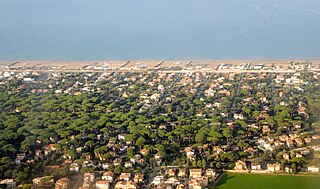
Fregenae, was a maritime town of ancient Etruria, situated between Alsium and the mouth of the Tiber. The modern Fregene is an Italian hamlet (frazione) of Fiumicino, in the Metropolitan City of Rome, Lazio. As of 2012 its population was of 6,445.
Caenophrurium was a settlement in the Roman province of Europa, between Byzantium and Heraclea Perinthus. It appears in late Roman and early Byzantine accounts. Caenophrurium translates as the "stronghold of the Caeni", a Thracian tribe.
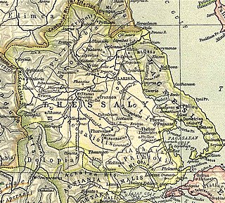
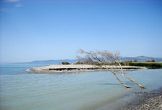
Larissa Cremaste was a town of Ancient Thessaly of less importance than Larissa, and was situated in the district of Achaea Phthiotis, at the distance of 20 stadia from the Maliac Gulf, upon a height advancing in front of Mount Othrys. It occupied the side of the hill, and was hence surnamed Cremaste, as "hanging" on the side of Mt. Othrys, to distinguish it from the more celebrated Larissa, situated in a plain. Strabo also describes it as well watered and producing vines. The same writer adds that it was surnamed Pelasgia as well as Cremaste.
Leuconium or Leucono was a town in the south of Pannonia, placed by the Antonine Itinerary on the road from Aemona to Sirmium, 82 Roman miles to the northwest of the latter town.
Mopsucrene or Mopsoukrene was a town in the eastern part of ancient Cilicia, on the river Cydnus, and not far from the frontier of Cataonia to which Ptolemy, in fact, assigns it. Its site was on the southern slope of Mount Taurus, and in the neighbourhood of the mountain pass leading from Cilicia into Cappadocia, 12 miles (19 km) north of Tarsus. It is celebrated in history as the place where the emperor Constantius died. In the Antonine Itinerary, it is called Namsucrone; in the Jerusalem Itinerary, it is called Mansverine. Its site was likely the same as the settlement and mutatio called Mapsoukrenai.
Siricae, also known as Siricis, and possibly as Saricha, was a town of ancient Cappadocia on the road from Comana to Melitene, 24 miles northwest of the first.
Nitazi or Nitalis or Nitazo was a town of ancient Cappadocia, inhabited in Roman and Byzantine times. It was located on the road between Mocissus and Archelais. The name appears as Nitazi in the Antonine Itinerary, as Nitazo in the Tabula Peutingeriana, and as Nitalis in the Jerusalem Itinerary.
Ochras was a town of ancient Cappadocia mentioned by the Antonine Itinerary. Ptolemy mentions a place Odogra or Odoga, in the district of Chammanene in Cappadocia, between the Halys River and Mount Argaeus, which William Smith conjectured was possibly the same as Ochras. Modern scholars do not accept the equivalence.
References

|title=(help)
- ↑ Richard Talbert , Barrington Atlas of the Greek and Roman World , ( ISBN 0-691-03169-X ), Map 46, notes.